Perth Waterfront

User avatar
blkmcs
Posts: 977
Joined: Mon Mar 02, 2009 2:44 pm
Location: Bayswater, WA

Re: Perth Waterfront

Postby blkmcs » Tue Mar 29, 2011 9:57 am

elStado wrote:..I work in the city as well, about 100m away from the foreshore area. I never use it because it is flat, barren and boring. Sure there's the occasional event held on it and the occasional worker laying on the grass, but IMO, it is a waste of space considering the potential it has due to it's size, shape, proximity etc to the city centre. I can't name any other decent city where they have ~40ha of prime empty space sitting smack bang on the city foreshore that is only used by a small amount of people and events during certain months of the year... it's a joke. I am all for keeping passive/active open green spaces for people to have lunch, kick a ball, relax, have a concert etc, but you don't need 40ha to do that. :!:
Some of us remember the annual fly in of small aircraft, an event that had to be cancelled once the Bell Tower was built, a fine example of the unintended consequences of thoughtless development.
Langley Park is an immense asset to the City, most other major cities around the world would love to have an emergency airstrip in the heart of the city.
If it were ever "developed" then it would never be possible to have this amenity again, once it is gone it is gone forever; a major loss to the public to enable a few developers to pocket some handsome profits.
Too old to live, too slow to die.

User avatar
jet-ski
Posts: 1404
Joined: Thu Dec 06, 2007 5:51 pm
Location: Perth WA
Contact:

Re: Perth Waterfront

Postby jet-ski » Tue Mar 29, 2011 2:05 pm

elStado - if you don't like it then you could easily go to another city which uses the so called 'underutilised' land along the riverbanks... like Brisbane and their very expensive floating walkway that became a huge hazard when it flooded... :P

without the space there would be no 'corporate games', no builders playing touch rugby, no personal trainers and their charges.... no space for 'Symphony in the Park' (so awesome watching WASO for free in the open air) or Opera in the Park, it would be lost as a vantage point for the fireworks, etcetcetc.
Bike Friday New World Tourist, Schwinn Le Tour Sport, Giant TCR, Giant STP2, 9:zero:7 fattie

User avatar
elStado
Posts: 2363
Joined: Tue Mar 16, 2010 12:27 am
Location: Syd, NSW

Re: Perth Waterfront

Postby elStado » Tue Mar 29, 2011 11:16 pm

jet-ski wrote:elStado - if you don't like it then you could easily go to another city which uses the so called 'underutilised' land along the riverbanks... like Brisbane and their very expensive floating walkway that became a huge hazard when it flooded... :P

without the space there would be no 'corporate games', no builders playing touch rugby, no personal trainers and their charges.... no space for 'Symphony in the Park' (so awesome watching WASO for free in the open air) or Opera in the Park, it would be lost as a vantage point for the fireworks, etcetcetc.
You're missing the point, I am all for these events and people using this space.. but you don't need 400,000m2 to do that. The amount of space there and being used is totally disproportionate. It is entirely possible to develop parts of the foreshore to make it more active and interesting while still keeping importance open parts for the people and uses you mentioned. The first thing we need to do is improve the cycling and pedestrian links from the city down to the foreshore. But saying that we should just leave that odd 40ha space totally unimproved and barren just because you would no longer be able land a jumbo jet along it is being a little NIBY'ist at best.
Check out my practical cycling and cycle touring website: VELOPHILE AUSTRALIA

User avatar
jet-ski
Posts: 1404
Joined: Thu Dec 06, 2007 5:51 pm
Location: Perth WA
Contact:

Re: Perth Waterfront

Postby jet-ski » Wed Mar 30, 2011 1:39 pm

um, ped links? last time I checked (yesterday) it was very easy to walk down there? cycle infrastructure in the city could be improved for sure but it's not hard to ride there either (though I don't mind riding down St George's Tce, so I'm not the type of cyclist the infrastructure is aimed at anyway).

The foreshore dev proposed is doing exactly that - developing some and leaving some.

I would (as always) question the wisdom of overcapitalising on the banks of a river. There are two ways the Swan could go. It could flood (and it has flooded that area before), or it could turn into a stinking cesspool. More urban development on the banks is not going to help avoid the stinking cesspool scenario because if anything it will increase contaminated runoff.
Bike Friday New World Tourist, Schwinn Le Tour Sport, Giant TCR, Giant STP2, 9:zero:7 fattie

User avatar
elStado
Posts: 2363
Joined: Tue Mar 16, 2010 12:27 am
Location: Syd, NSW

Re: Perth Waterfront

Postby elStado » Wed Mar 30, 2011 2:40 pm

jet-ski wrote:um, ped links? last time I checked (yesterday) it was very easy to walk down there? cycle infrastructure in the city could be improved for sure but it's not hard to ride there either (though I don't mind riding down St George's Tce, so I'm not the type of cyclist the infrastructure is aimed at anyway).
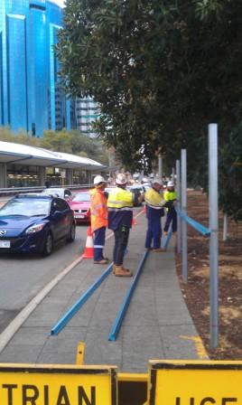
I don't mean literal paths. Although on that note they are sub-standard in many sections anyway making the pedestrian, who should be 'king' in a dense urban environment, feel like a second class citizen. Look at the signs and poles that litter streetscape along the bottom section of William St for example. Pedestrians have to duck and weave through a obstacle course of barriers while not being run down by footpath cyclists.

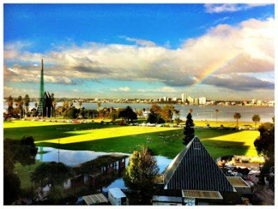
I was actually talking about visual and activity links from the city to the foreshore. Currently it's like they are two different places, not enough people are drawn to the foreshore area (this includes the grassed expanses and also the literal foreshore.. which is nothing but a retaining wall and the occasional tree). A tourist getting off the train in Perth CBD would have no idea that there is a large open space and foreshore just 5 minutes walk away.. there's simply nothing to draw them to that area. Where if you look at other cities the foreshore is the central focus. Even if you have no orientation you will end up along the foreshore as that is where most of the action is and where all the paths lead to. Look at places like Melbourne, Singapore etc for an example. Look at where the majority of activities, festivals etc are located.
The foreshore dev proposed is doing exactly that - developing some and leaving some.
Whether it is the most effective use of space is to be questioned, they leave a lot of large areas with nothing. I am not suggested to put high rise sky scrapers along the whole foreshore area. But I am urging people to be a little bit imaginative about what we could use that space for whilst also retaining key large open areas for the existing positive uses as you mentioned previously. Some of the ideas proposed in the 'What If?' project were quite good. My company actually made a submission, but it was the design/landscape architects who did it, not the planning crew.
I would (as always) question the wisdom of overcapitalising on the banks of a river. There are two ways the Swan could go. It could flood (and it has flooded that area before), or it could turn into a stinking cesspool. More urban development on the banks is not going to help avoid the stinking cesspool scenario because if anything it will increase contaminated runoff.
+1 With any development, especially along a river foreshore and reclaimed land we have to be extremely careful with it. Poor research and design can and will result in gigantic, expensive stuff ups.
Check out my practical cycling and cycle touring website: VELOPHILE AUSTRALIA

User avatar
rolandp
Posts: 2316
Joined: Fri Mar 14, 2008 11:47 am
Location: Hillarys - Perth, WA

Re: Perth Waterfront

Postby rolandp » Wed May 04, 2011 1:15 am

Public comment has been requested relating to Metropolitan Region Scheme Amendment to support the Perth Waterfront:
http://www.planning.wa.gov.au/1203-41Pe ... df?id=2526

Is anyone in the 'planning' area who can provide advice on if we (cyclists) should be providing a written response?

Submissions close 27 May 2011. I only found the document by accident when searching for additional information relating to this area.

For example page 3 indicates:
An island within the inlet that provides a unique landscape experience, and a range of recreational, interpretive and public event opportunities. Connected by two bridges, the island also completes an attractive pedestrian circuit around the waterfront.
Does this mean cyclists will not be able to use the bridges as this document has not specifically indicated that the bridges will be shared paths or even better, dedicated bridges for cyclists?

User avatar
elStado
Posts: 2363
Joined: Tue Mar 16, 2010 12:27 am
Location: Syd, NSW

Re: Perth Waterfront

Postby elStado » Wed May 04, 2011 1:16 pm

Sigh. It's a pity to see state planning is still in the 'release and defend' approach to planning. You would think that after 30 years of contemporary planning mostly being against this approach it would be extinct by now? It seems that planning is going backwards.

Yes, 100% every single cyclist organisation and lobby group should be making submissions. The more people putting pressure on them the better the chances that they might make sure to incorporate cycle friendly design into the final plan.
Submissions on the amendment

The WAPC invites people to comment on this proposed amendment to the MRS.
The amendment is being advertised for public submissions for a period of three months from
Tuesday, 22 February 2011 to Friday, 27 May 2011.

Copies of the amendment will be available for public inspection at:
i) Western Australian Planning Commission, 469 Wellington Street, Perth;
ii) Cities of Perth, Fremantle and South Perth and the Town of Vincent;
iii) the State Reference Library, Northbridge.

Written submissions on the amendment should be sent to:
The Secretary
Western Australian Planning Commission
469 Wellington Street
PERTH WA 6000

and must be received by 5pm Friday, 27 May 2011.
All submissions received by the WAPC will be acknowledged.
Found this interesting on page 4-5:
The masterplan is also based on the premise that for the waterfront to function as an
extension of the city, then all roads must be designed as normal city streets rather than
feeders to a freeway system. The section of Riverside Drive between Barrack and William
Streets is therefore proposed be removed, and two-way traffic reintroduced into Barrack
Street, the Esplanade, Mounts Bay Road and William Street. [Not a lot of good for cyclists considering how terrible these streets are for cycliing now and in the future looking at how they are being redesigned].

In addition, the masterplan places equal or greater emphasis on alternative forms of
transport by consolidating bus, rail and commuter ferry services, and improving the comfort
and legibility of pedestrian and cycle networks. [But how? This needs to be investigated further in the full plan/design]

Transport planning and modelling undertaken in consultation with the City of Perth,
Department of Transport, Main Roads WA, Public Transport Authority and Planning and
Transport Research Centre, has confirmed that the masterplan places a greater emphasis
on green transport modes (walking, cycling and public transport) to maximise accessibility to
and within the project area
; and although it is anticipated that there will be some increased
levels of congestion, the traffic modelling clearly shows that the impacts are manageable if a
sustainable multi-modal approach is taken.

The proposed Public Purposes Special Use reservation will affect portions of the Narrows
Interchange 'Primary Regional Road' reservation and Riverside Drive 'Other Regional Road'
reservation. This is necessary to facilitate the further planning and design of the Perth
Waterfront road layout, and ensure that it is integrated with the existing network.
Check out my practical cycling and cycle touring website: VELOPHILE AUSTRALIA

User avatar
rolandp
Posts: 2316
Joined: Fri Mar 14, 2008 11:47 am
Location: Hillarys - Perth, WA

Re: Perth Waterfront

Postby rolandp » Thu May 26, 2011 8:22 am

BTA have provided a response the Metropolitan Regional Scheme "Perth Waterfront".

Responses close Friday 27-May-2011 if you want to put in your own response.

User avatar
rolandp
Posts: 2316
Joined: Fri Mar 14, 2008 11:47 am
Location: Hillarys - Perth, WA

Re: Perth Waterfront

Postby rolandp » Thu Jun 30, 2011 11:39 pm

Made a joke yesterday that it looked like the Perth Waterfront development had started due to the amount of water on it. Collegue sent this image later which shows how much there is.
Image

The additional thing about the picture, is how many cars are on Riverside Drive, image taken around 9:30am and the traffic is banked up. Not looking forward when it gets diverted to other roads including St Georges Tce, The Esplanade etc.

User avatar
hiflange
Posts: 1938
Joined: Tue May 05, 2009 9:27 pm
Location: Perth
Contact:

Re: Perth Waterfront

Postby hiflange » Mon Feb 06, 2012 10:32 am

There is some significant organised opposition to the Barnett government's current waterfront plan, City Gatekeepers; http://citygatekeepers.com.au/
They're emphatic that they're not opposed to development of the foreshore, just the ill conceived current plan.
There's a paper petition you can download print and sign, there's also an online petition here.

I'd encourage cyclists to sign both. East west access along the river will be disrupted for a significant period of time and ultimately be replaced with a very wiggly bridge (the wiggles are to accommodate the rapid rise above the water feature). The bridge will be for peds as well. Knowing WA governments' (of all stripes) propensity for penny pinching there's a good chance that it'll wind up like Trafalgar Bridge in E Perth - you'll be obliged to walk your bike over it.

The CoP have already buggered east west access for cyclists trying to cross the city, the destruction of Riverside Drive cycle paths will be a significant loss. With regards to Riverside Dve motor traffic, Barnett and Day are planning to redirect it through the Graham Farmer Freeway tunnel and down Mill Point Rd South Perth. Polly's pipe will have an extra lane painted in. I don't think Mill Point Road is going to get anything.

Aside from the petitions there's also a rally on Feb 26 at 10am.

User avatar
rustguard
Posts: 1415
Joined: Thu Jul 10, 2008 2:31 am
Location: Perth, WA
Contact:

Re: Perth Waterfront

Postby rustguard » Wed Feb 08, 2012 12:33 am

Thanks for the info, i feel duty bound to attend as this development is just too close to the river.

User avatar
rolandp
Posts: 2316
Joined: Fri Mar 14, 2008 11:47 am
Location: Hillarys - Perth, WA

Re: Perth Waterfront

Postby rolandp » Wed May 09, 2012 1:02 am

So it begins, the first casualty, the shared path on William St (between Riverside Drive and The Esplanade, East side):
Image Image

The fence installed is too close to the shared path, so you can't get a bike around the light post (second image).

Public comment on the design guidlines close 5th June 2012. Check out the the proposed cycling infrastructure on page 15 of this document. William and Barrack St are indicated as part of the cycle network, as is the new bridge over the Perth Waterfront. Hopefully this matches with the City of Perth Bike Plan due out next week.

User avatar
elStado
Posts: 2363
Joined: Tue Mar 16, 2010 12:27 am
Location: Syd, NSW

Re: Perth Waterfront

Postby elStado » Wed May 09, 2012 1:08 am

rolandp wrote:So it begins, the first casualty, the shared path on William St (between Riverside Drive and The Esplanade, East side)
That's a shared path? I never figured, considering it's so narrow and clogged with various sign posts and bus stands in the way. Easier to just gun it straight down WIlliam and claim the lane (I go south towards the riverside shared path in the evenings coming from the CBD). This isn't going to be fun..
Check out my practical cycling and cycle touring website: VELOPHILE AUSTRALIA

User avatar
rolandp
Posts: 2316
Joined: Fri Mar 14, 2008 11:47 am
Location: Hillarys - Perth, WA

Re: Perth Waterfront

Postby rolandp » Wed May 09, 2012 1:16 am

I've contacted the Council earlier this year on the status of this path, as there are dual pedesdrian/cycling lights at Riverside Drive and as per the Road Traffic Act, it is then deemed a shared path as there is no 'end of cycling markings'.

Going North, it is of course a one-way road at this time, so the only access into the CBD at this location is the shared path.

User avatar
rolandp
Posts: 2316
Joined: Fri Mar 14, 2008 11:47 am
Location: Hillarys - Perth, WA

Re: Perth Waterfront

Postby rolandp » Wed May 09, 2012 1:34 am

And page 43 - section 4.2 Bicycle Parking indicates the type of facilities buildings in this area are required to provide. This includes bike storage for 10% of building staff. Does anyone have any views on this amount, is this acceptable?

User avatar
elStado
Posts: 2363
Joined: Tue Mar 16, 2010 12:27 am
Location: Syd, NSW

Re: Perth Waterfront

Postby elStado » Wed May 09, 2012 2:05 am

rolandp wrote:And page 43 - section 4.2 Bicycle Parking indicates the type of facilities buildings in this area are required to provide. This includes bike storage for 10% of building staff. Does anyone have any views on this amount, is this acceptable?
At the current rate of cycling yes I think it is enough. Essentially this should mean that a building designed, for example, for 2000 workers will have 200 bike racks which is plenty. However these facilities only go in once, and we are aiming for much higher usage of bicycles into the city (apparently) according to the WABNP. So a 10% provision might not be enough to accommodate future usage (e.g. 10/15+ years time).

There's also major issues with a shortage of lockers and showers/change room space even in the newer buildings, let alone the older buildings. E.g. 140 William has a chronic shortage of lockers (I know from personal experience) so everyone is fighting to get one and it puts a lot of people off cycling into work. This is something that needs to be addressed urgently. We need real guidelines and standards for EoTF, not just figures.
Check out my practical cycling and cycle touring website: VELOPHILE AUSTRALIA

J Quinton
Posts: 237
Joined: Fri Jan 06, 2012 7:52 pm

Re: Perth Waterfront

Postby J Quinton » Thu May 10, 2012 10:32 pm

How much are the authorities going to fine you if you don't dismount on "The Bridge."

If Im heading east, think Ill be either crossing the narrows or heading toward Windan bridge once this is "finished."

The earlier comments about the softwall/vegetation are spot on. And will remain spot on. If you look west from the narrows now you'll see a badly erected silt curtain around a drain. Construction companies are continually restoring the limestone/concrete hard walls on the river. Bet they run in at 1million dollars per project. Gets rebuilt every five years. Until you line the river wall with vegetation that actually holds the shore together, you're wasting a lot of money.

Will not be long until they are restoring the walls inside the waterfront project either. Brushmatressing looks better and lasts longer: https://www.google.com.au/search?hl=en& ... iAehiKjQAw

User avatar
rolandp
Posts: 2316
Joined: Fri Mar 14, 2008 11:47 am
Location: Hillarys - Perth, WA

Re: Perth Waterfront

Postby rolandp » Fri May 11, 2012 12:17 am

Article in The West today indicates:
The bridge is planned to provide pedestrian and cycle access to the $2.6 billion project's island feature.

Under the current designs, only commuter ferries and boats up to 12m in length would be able to pass under the bridge.

However, MRA acting chief executive Tony Morgan said yesterday the authority was discussing whether the bridge could be built so it could be opened at certain times to allow bigger boats and boats with masts into the 2.7ha inlet.
If this occurs, it had better not be in peak hour commuting times.

mstknvt
Posts: 6
Joined: Tue Apr 17, 2012 2:54 am
Location: Perth WA

Perth Waterfront

Postby mstknvt » Fri May 11, 2012 1:51 am

Just makes me wonder.... Since we reclaimed all that land then why don't we reclaim more land into the river and build it there??? Keeps the open areas intact, keeps riverside drive intact for traffic flow, and keeps the pollies happy with their new development.

User avatar
ColinOldnCranky
Posts: 6734
Joined: Fri Feb 27, 2009 4:58 pm

Re: Perth Waterfront

Postby ColinOldnCranky » Mon May 14, 2012 10:47 pm

rolandp wrote:So it begins, the first casualty, the shared path on William St (between Riverside Drive and The Esplanade, East side):
Image Image

The fence installed is too close to the shared path, so you can't get a bike around the light post (second image).

Public comment on the design guidlines close 5th June 2012. Check out the the proposed cycling infrastructure on page 15 of this document. William and Barrack St are indicated as part of the cycle network, as is the new bridge over the Perth Waterfront. Hopefully this matches with the City of Perth Bike Plan due out next week.
Is that image of the bike between the post and the curb Roland? 'Cos I didn't think there was enough room on the other side before any fence was added was there? I don't ride that side myself but I do not recall seeing many riding around the posts to the east of the poles. I know that you ride it regularly. I may have to look again.
Unchain yourself-Ride a unicycle

User avatar
ColinOldnCranky
Posts: 6734
Joined: Fri Feb 27, 2009 4:58 pm

Re: Perth Waterfront

Postby ColinOldnCranky » Mon May 14, 2012 10:58 pm

mstknvt wrote:Just makes me wonder.... Since we reclaimed all that land then why don't we reclaim more land into the river and build it there??? Keeps the open areas intact, keeps riverside drive intact for traffic flow, and keeps the pollies happy with their new development.
My recollection is that that is sort of the thing that the gatekeepers (I think that is what they called themselves) proposed. The trouble is all that they served up looked like a hastily drawn sketch which did not attend to detail which made them even less credible than Colin Barnett as an architect. My favourite coffee shop, a heritage listed building, got wiped out in their work of fiction.

I do not know if I want this development to go ahead or not. Certainly I do see it causing much traffic congestion.

But I am against Colin Barnett doing things that cost an arm and a leg based largely on his own whim. I look at the footy stadium and so not see any input from our own public service planners and engineers, let alone public input. And I see more of the same here.
Unchain yourself-Ride a unicycle

User avatar
rolandp
Posts: 2316
Joined: Fri Mar 14, 2008 11:47 am
Location: Hillarys - Perth, WA

Re: Perth Waterfront

Postby rolandp » Mon May 14, 2012 11:38 pm

ColinOldnCranky wrote:Is that image of the bike between the post and the curb Roland? 'Cos I didn't think there was enough room on the other side before any fence was added was there? I don't ride that side myself but I do not recall seeing many riding around the posts to the east of the poles. I know that you ride it regularly. I may have to look again.
Colin, the image is of the east side of the pole, and there was enough room to walk and cycle on that side before the fencing went up. I'm always amazed that light/street signs are installed to block the path, in this case the light pole could have been located to the east of the path when initially installed.

Heard back from City of Perth:
'..on inspection today, there is no obstruction of the footway as the hoarding has been completed.'

giwi2
Posts: 372
Joined: Thu Feb 19, 2009 11:18 pm
Location: Perth - S.O.R

Re: Perth Waterfront

Postby giwi2 » Tue May 15, 2012 11:11 pm

The fencing and hoarding works as well as excavators you are seeing are the start of the Forwards Works package (essentially relocatiing major services out of the foot print of the so-called inlet). I know this cos i am involved but only from an environmental management point of view and not from a traffic mgmt PoV.
2009 Scott Sportster
2009 Specialized Roubaix Expert

Image

User avatar
rolandp
Posts: 2316
Joined: Fri Mar 14, 2008 11:47 am
Location: Hillarys - Perth, WA

Re: Perth Waterfront

Postby rolandp » Tue May 15, 2012 11:58 pm

I had a small laugh today, unfortuantly at the cost of the general public. MRA had set-up a huge sign indicating what the project is about, around 4 months ago. The hoarding now hides the sign, so you can only see the top of it now. Would imagine the sign moving soon.

Good luck on the environmental management point of view, would imagine there are lots of things to consider in this development.

User avatar
rolandp
Posts: 2316
Joined: Fri Mar 14, 2008 11:47 am
Location: Hillarys - Perth, WA

Re: Perth Waterfront

Postby rolandp » Wed Jun 06, 2012 12:48 am

The BTA provided a response to the Perth Waterfront Design guidelines.

Who is online

Users browsing this forum: No registered users