Page 4 of 9
Re: Perth Waterfront
Posted: Tue Jun 19, 2012 11:08 pm
by rolandp
Recieved a News Letter today from
MRA, with sections relating to cycling copied below:
Works Period: 18–30 June 2012
Commence works to relocate the dual use path along Riverside Drive, west of William Street. These works are expected to take approximately two weeks and will be complete by the end of June. The existing dual use path will remain in operation until works on the relocated path are complete.
Traffic Impacts
In addition, the eastern-most lane of William Street, between The Esplanade and Riverside Drive and the footpath will be closed. Pedestrians are advised to use the western footpath alongside the Esplanade Busport during this time. There will be no disruption for traffic accessing Riverside Drive (east and west) from William Street.
Should the required works not be completed on the 23 June, the lane and footpath closure on William Street only will be repeated the following Saturday (30 June).
I've included the section on 'footpath' on William St as I know lots of cyclists using it, including me.
There is also a
Works Staging Map, which shows that there will be a new bus terminal entrance off Mounts Bay Rd (looks like via The Esplanade/William St corner), so expect more buses to be travelling in this location.
Re: Perth Waterfront
Posted: Wed Jun 20, 2012 7:31 am
by Tornado
Re: Perth Waterfront
Posted: Thu Sep 06, 2012 3:33 pm
by Vivifyer
released DG's on ped and cycling access.

Full document here
http://www.mra.wa.gov.au/Documents/Eliz ... elines.pdf
Re: Perth Waterfront
Posted: Thu Sep 06, 2012 4:52 pm
by Shifter
'The bridge' is going to be a nightmare. I also noted how the document doesn't state any about cycling infrastructure enhancements except end of trip facilities in the buildings.
Re: Perth Waterfront
Posted: Thu Sep 06, 2012 5:55 pm
by Baalzamon
I for one will never use that bridge path, except to push my bike/trike across
Re: Perth Waterfront
Posted: Thu Sep 06, 2012 10:27 pm
by Pushy
Baalzamon wrote:I for one will never use that bridge path, except to push my bike/trike across
We will all probably have to, like the bridge in East Perth. You can count on the CoP.
Re: Perth Waterfront
Posted: Fri Sep 07, 2012 7:46 pm
by ColinOldnCranky
Pushy wrote:Baalzamon wrote:I for one will never use that bridge path, except to push my bike/trike across
We will all probably have to, like the bridge in East Perth. You can count on the CoP.
I am confused. Doesn't it clearly define it's use? (2.2.7, 2.2.9) Does CoP have an over-riding say? Perhaps they do.

As far as how suitable it will be for mixing peds and cyclists, are their detailed drawings indicting it is worse than, say, the existing fenced skinny lumpy stretch immediately south of the Function Centre? Riders are all using that already and there is probably as much ped traffic during commute hours now as there will be when this thing is built.
I may accept however that on weekends during the day there will be heaps of peds about. Though, from my observation, cyclists even then seem to prefer earlier mornings than the ped latte set.
Still, on a positive note, if you choose already to avoid it then it will just be a bit more roomy for the rest of us.

Re: Perth Waterfront
Posted: Sat Sep 08, 2012 1:40 pm
by ColinOldnCranky
For the record I am not at all in favour of the state going further into debt or using revenues that are falling to provide this. I think we have a premier who realises that a leaders "legacy" is enhanced in the long run based on what they left. What they cut out does not feature further down the line no matter how much worse we may be off. And while other premiers are not much different, Colin's fellows are still in awe of his comeback from being a joke to leading them to regaining government and getting the "top dog" mantle of current state leaders. Hence he gets to do as he wishes - a one man cabinet so to speak.
End of rant
I note from the diagrams that that skinny bit right on the river wall is shifting inland a bit. A definite improvement.
Re: Perth Waterfront
Posted: Mon Feb 04, 2013 9:19 pm
by nachoman
The bike path along Riverside Drive from Plain St to the Bell Tower is currently being resurfaced. It also looks wider in parts.
http://imgur.com/MdCSDWY
Re: Perth Waterfront
Posted: Tue Feb 05, 2013 12:21 pm
by wexford
nachoman wrote:The bike path along Riverside Drive from Plain St to the Bell Tower is currently being resurfaced. It also looks wider in parts.
Very nice. I like to blast along that bit when there's a good tail wind, and even with the pleasant riverside walk a few metres over to the side there'll still be a fair number of peds using it. As is their right, of course, but it means that I have to slow down!
Re: Perth Waterfront
Posted: Fri Feb 08, 2013 3:47 am
by casual_cyclist
ColinOldnCranky wrote:For the record I am not at all in favour of the state going further into debt or using revenues that are falling to provide this. I think we have a premier who realises that a leaders "legacy" is enhanced in the long run based on what they left. What they cut out does not feature further down the line no matter how much worse we may be off. And while other premiers are not much different, Colin's fellows are still in awe of his comeback from being a joke to leading them to regaining government and getting the "top dog" mantle of current state leaders. Hence he gets to do as he wishes - a one man cabinet so to speak.
End of rant
I note from the diagrams that that skinny bit right on the river wall is shifting inland a bit. A definite improvement.
I was discussing the history of this project with some colleagues today. All of them swore that it was Barnie that dreamed it up. Incorrect. I recalled that it was a labor party project but I couldn't remember which minister. It turns out it was happy Carps who dreamed it up in 2008.
http://www.abc.net.au/news/2008-02-13/c ... an/1042022. Enlarge the photo and you will see a picture of what was dubbed "Dubai on Swan" at the time. From the looks of the photo it was a much more ambitious (i.e. expensive) project. This is Perth Waterfront lite in comparison.

Re: Perth Waterfront
Posted: Fri Feb 08, 2013 7:49 pm
by ColinOldnCranky
casual_cyclist wrote:ColinOldnCranky wrote:For the record I am not at all in favour of the state going further into debt or using revenues that are falling to provide this. I think we have a premier who realises that a leaders "legacy" is enhanced in the long run based on what they left. What they cut out does not feature further down the line no matter how much worse we may be off. And while other premiers are not much different, Colin's fellows are still in awe of his comeback from being a joke to leading them to regaining government and getting the "top dog" mantle of current state leaders. Hence he gets to do as he wishes - a one man cabinet so to speak.
End of rant
I note from the diagrams that that skinny bit right on the river wall is shifting inland a bit. A definite improvement.
I was discussing the history of this project with some colleagues today. All of them swore that it was Barnie that dreamed it up. Incorrect. I recalled that it was a labor party project but I couldn't remember which minister. It turns out it was happy Carps who dreamed it up in 2008.
http://www.abc.net.au/news/2008-02-13/c ... an/1042022. Enlarge the photo and you will see a picture of what was dubbed "Dubai on Swan" at the time. From the looks of the photo it was a much more ambitious (i.e. expensive) project. This is Perth Waterfront lite in comparison.
That is fine, most ideas are borrowed from others. The sinking of the railway line has been proposed since forever. And the previous government, from memory, also floated a scheme down at the Concet Hall instead.
But when it goes further and actually gets funded and commenced it should first have been subject to conflicting views and argued about by of others such as cabinet, the public, engineers, hydrographers, etc etc. The point I make is that Barnett doesn't seem to have to as his cabinet is in awe of him (it seems). So we get a one man thought-bubble that gives us a footy stadium in a place that was not on the list recomended by the Langoulant panel, nor does it seem to have been run by engineers etc.
Meantime in a leadup to an election he suddenly discovers the need to do some other costly stuff as the state debt is ballooning from $3B to $25B. Which means that neither party will be funding any of those other things.
The looks of the photo you refer to with futuristic building that you imply (probably correctly) as being more expensive is the private sector contribution and will look like tha only if that sector sees value in it. It may still look like that or it may look more mundane but either way that will be funded by private enterprise.
Don't get me wrong - I am ecstatic for the idea of making some use of the best or second best capital city water in the country. I think most of the shore along there is as boring as the proverbial bat excrement. My concern is the failure to develop the ideas and options before committing us to them.
Re: Perth Waterfront
Posted: Thu Feb 14, 2013 12:50 am
by rolandp
Anyone else get lost in the maze of fences and constantly moving shared path. Feels like an episode of Harry Potter with the moving stair cases.
If you turn off at William St, you need to continue down to the Bell Tower and do a hook back, when heading east. When heading west don't continue along the original path, as you will hit a dead end and you can only cross at William St:
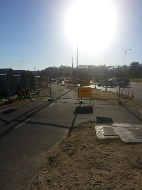
I do love the care to attention provided in these directional signs which are A3 pieces of paper. I didn't know we know need superman vision to read these signs when riding.
What I can't work out, why the new road lanes are being installed, they will be underwater in the near future. So why build them? Once these new road lanes are installed, how do you cross them to get to William St? If you use William St, how do you get back onto the PSP?
You then have the issue that Barrack St is now one way (you can only head north), so unless you ride on the footpath, then how do you get into Perth, in particular, as my guess is that William St won't be accessable once those new roads lanes are operational.
Minister of Transport announced last week
'More Information for Motorists to Plan Journey'. Great idea, wonder were they got it from as I asked for one to be provided for cyclists late last year, none provided at this time.
Re: Perth Waterfront
Posted: Thu Feb 14, 2013 11:46 pm
by elStado
rolandp wrote:Anyone else get lost in the maze of fences and constantly moving shared path. Feels like an episode of Harry Potter with the moving stair cases.
Yep. Threw everyone out. We were all pootling along the path wondering where we were supposed to be going haha.
Re: Perth Waterfront
Posted: Fri Feb 15, 2013 12:52 am
by rolandp
I was told to slow down this morning, looked down at the speedo and I was doing 15kph, so I turned around and asked what speed I should be doing. There had been an accident earlier on the shared path, I was told. I then started the questions, why.. Why are we riding on paths that aren't designed for bikes. Why aren't there traffic controllers in place to help direct us. Why is a road being built that will be, destroyed in the near future. Why are diversion signs printed on a3 paper etc etc. response, it is a work in progress
Was also told that William st will be inaccessible in the near future and to use barrack st, though my explanation that this was a footpath, he then suggested I could use other entrances down riverside drive.
Have requested information from mra.
If you were the one in the accident, hope it was not serious.
Re: Perth Waterfront
Posted: Fri Feb 15, 2013 10:25 am
by blkmcs
It's all part of the bigger picture Roland
Re: Perth Waterfront
Posted: Fri Feb 15, 2013 12:59 pm
by CycleSnail
rolandp wrote:I was told to slow down this morning, looked down at the speedo and I was doing 15kph, so I turned around and asked what speed I should be doing. There had been an accident earlier on the shared path, I was told. I then started the questions, why.. Why are we riding on paths that aren't designed for bikes. Why aren't there traffic controllers in place to help direct us. Why is a road being built that will be, destroyed in the near future. Why are diversion signs printed on a3 paper etc etc. response, it is a work in progress
Was also told that William st will be inaccessible in the near future and to use barrack st, though my explanation that this was a footpath, he then suggested I could use other entrances down riverside drive.
Have requested information from mra.
If you were the one in the accident, hope it was not serious.
The original plan was to have pedestrians using the Barrack street footpath, and force cyclist to use Victoria Avenue .....
Re: Perth Waterfront
Posted: Fri Feb 15, 2013 1:47 pm
by ColinOldnCranky
rolandp wrote:I was told to slow down this morning, looked down at the speedo and I was doing 15kph, so I turned around and asked what speed I should be doing. There had been an accident earlier on the shared path, I was told. I then started the questions, why.. Why are we riding on paths that aren't designed for bikes. Why aren't there traffic controllers in place to help direct us. Why is a road being built that will be, destroyed in the near future. Why are diversion signs printed on a3 paper etc etc. response, it is a work in progress
Was also told that William st will be inaccessible in the near future and to use barrack st, though my explanation that this was a footpath, he then suggested I could use other entrances down riverside drive.
Have requested information from mra.
If you were the one in the accident, hope it was not serious.
It's all being done as forced training for the Tour d'Perth.
I know things are bad when YOU wander of and have a rant Roland.

Chin up.
Re: Perth Waterfront
Posted: Fri Feb 15, 2013 2:27 pm
by blkmcs
rolandp wrote:...Why are diversion signs printed on a3 paper etc etc. response, it is a work in progress....
Somebody is listening Roland, there was a nice big sign showing directions to the City or to the Narrows this morning, thanks for making the effort.
Re: Perth Waterfront
Posted: Sun Feb 17, 2013 12:21 am
by nachoman
A warning if riding along Riverside Drive tomorrow morning (Sunday), roads might be blocked and you might end up a different colour
http://thecolorrun.com/australia/perth/" onclick="window.open(this.href);return false;
http://thecolorrun.com/wp/wp-content/up ... aceMap.jpg" onclick="window.open(this.href);return false;
Re: Perth Waterfront
Posted: Mon Feb 18, 2013 2:46 pm
by wellington_street
Ah so that's why such a large stretch was closed. I went through after the excitement had finished by the looks of it.
The diversion signage was OK although not great - I was looking for Mounts Bay Road and options of "Narrows" and "City" didn't really help me as I wasn't sure if Narrows would force me over the bridge. A bit ambiguous imo.
Re: Perth Waterfront
Posted: Mon Feb 18, 2013 11:45 pm
by elStado
Ahhg. What is going on now at the connection to the foreshore. My usual ride home today was marred by ridiclous traffic and lots of confused cyclists trying to get to the cycle path. I am heading from the CBD towards the southern Kwinana PSP. What's the best way? Down William, left onto Esplanade, right onto Barrack and then connect to the PSP...?

Re: Perth Waterfront
Posted: Tue Feb 19, 2013 12:09 am
by rolandp
That was basically my route home tonight. Anyone else get filmed by the News camera's, one located cnr The Esplanade/William St, the other located cnr The Esplanade/Barrack St.
I would be surprised that it was on this evening as I went through around 5:30pm.
Re: Perth Waterfront
Posted: Tue Feb 19, 2013 12:27 pm
by roller
accidentally got caught in this yesterday, went down william street as normal, hoping to get on the bike path to the narrows.
BUH BOW.
took me an age to get up the esplanade and then down barrack and on to the path at the belltower.
will be taking william-hay-milligan-mount st from now on.
Re: Perth Waterfront
Posted: Tue Feb 19, 2013 12:37 pm
by wellington_street
elStado wrote:Ahhg. What is going on now at the connection to the foreshore. My usual ride home today was marred by ridiclous traffic and lots of confused cyclists trying to get to the cycle path. I am heading from the CBD towards the southern Kwinana PSP. What's the best way? Down William, left onto Esplanade, right onto Barrack and then connect to the PSP...?
The other option is St Georges Terrace then down either Mount or Mill Streets to Mounts Bay Road and onto the PSP that way.