Page 1 of 2
Widening of cycle way increases traffic congestion - Perth
Posted: Tue Mar 26, 2013 12:52 am
by rolandp
From
Works and Urban Development Committee - City of Perth:
Traffic Congestion – Sutherland and Railway Streets, West Perth Intersection
Cr McEvoy raised concerns regarding increased traffic congestion due to works located at the Sutherland and Railway Streets intersection. The Director Planning and Development advised that congestion may be due to temporary changes in signalling for works associated with the widening of the cycle way on Railway / Roe Streets, and that a report providing an update on these works would be presented at future Works and Urban Development Committee meeting.
The only work I'm aware of is part of the
CBD Transport Plan, and the last I heard was:
Detailed design and construction of the recommended facility for Roe Street (scheduled from 2014/2015 to 2015/2016).
There currently isn't a 'cycle way' at this location, and as far as I'm aware it is a foot path, based on
DoT's Bike Maps.
What is being built at Sutherland/Railway Streets?
Re: Widening of cycle way increases traffic congestion - Per
Posted: Tue Mar 26, 2013 3:12 pm
by Sinner
From the City of Perth Budget for 2012/13:
Black Spot Program - Sutherland Sutherland 174,028
Sutherland / Roe / Railway Footpath Construct Sutherland / Roe / Railway Pde 297,528
Re: Widening of cycle way increases traffic congestion - Per
Posted: Tue Mar 26, 2013 7:59 pm
by MyNameIsNoone
I know there's a ton of work going on, but I don't see any of it relating to a cycle path.
Re: Widening of cycle way increases traffic congestion - Per
Posted: Wed Mar 27, 2013 5:58 pm
by BrownBike
It looks wide enough to be a cycle path - wasn't the PSP going to be extended down Roe all the way to Thomas St? There's that 200m strip of dark tarmac recently laid along the side of Railway St between Sutherland St and halfway down City West.
Re: Widening of cycle way increases traffic congestion - Per
Posted: Wed Mar 27, 2013 6:37 pm
by eldavo
Are "cycle ways" that we have the same as road surface line separations?
Surface separated PSP's and SP's are not cycle ways even though we've colloquially called the PSP's that for years?
Question marks as I rarely read of cycle ways amongst PSP's, SP's, and footpaths.
Re: Widening of cycle way increases traffic congestion - Per
Posted: Sun Apr 07, 2013 5:49 pm
by rolandp
Took a trip home via this location:

Not signed posted for cyclists, either before this development or during.
It has taken out one of the road lanes, and as Sinner pointed out, it is a Black Spot location as well as development of a footpath.
Weird that CoP initially indicated this as 'widening of cycle way'. Works and Urban Development Committee meet tomorrow night, so hopefully the minutes will identify what is going on.
Re: Widening of cycle way increases traffic congestion - Per
Posted: Sat Apr 13, 2013 11:10 am
by rolandp
Copied from RedRider:
From
CoP's Works and Urban Development Committee:
• Traffic Congestion – Sutherland and Railway Street intersection (WK 18/03/13).
The Director Planning and Development advised that, in response to the concerns raised by the Works and Urban Development Committee at its meeting held on 18 March 2013, additional signage regarding the new principal shared path will be installed on Railway / Roe Streets. A report detailing the status of the intersection works at Sutherland and Railway Streets is to be presented to the Works and Urban Development Committee meeting scheduled to be held on 10 June 2013.
Looks like it is a new principal shared path.
Shame that there is no marketing for it, given that I can find every main road development for the
next 12 months is located on MainRoadswebsite, and CoP are indicating now for additional signage.
Shame it looks like it will not be grade separated like the other side of the Railway and we will be required to stop at the traffic lights.
Re: Widening of cycle way increases traffic congestion - Per
Posted: Fri Jan 24, 2014 12:56 am
by rolandp
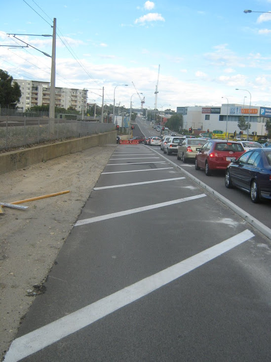
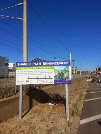
10 months on.
Sign is still up indicating SHARED PATH ENHANCEMENT:
From Roe St, looking west:

No SHARED PATH signs installed to allow us on any of the footpaths in the area.
From Roe St, looking east:
definitely no shared path, or even a footpath.
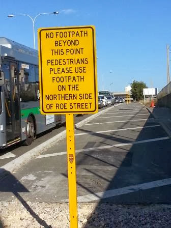
Near the underpass area:
No signs indicating shared path, and good luck riding through here - this was a section with new paving
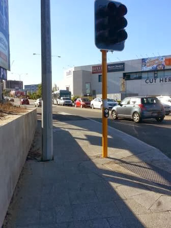
Further west on Roe St:
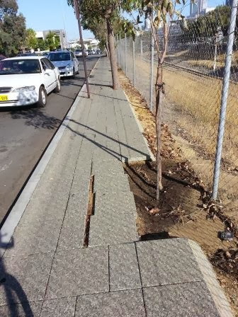
Broken sections of the 'shared path', which makes it difficult to walk or ride on. Trees located in the middle of the 'shared path', with signs installed close together, good luck riding through here.
How long does it take to install a shared path? Answer - 10 months and counting.
Re: Widening of cycle way increases traffic congestion - Per
Posted: Fri Jan 24, 2014 1:25 am
by Red Rider
The reason for the planned path was to alleviate pressure due to Lizzy Key. I'm not sure why they blocked off a turning lane when the bike path wasn't ready to be done for ages.
I believe they haven't done the bike path yet due to all the work along Roe St still. Once they have their ducks in a row they may complete it.
Re: Widening of cycle way increases traffic congestion - Per
Posted: Fri Jan 24, 2014 12:31 pm
by wellington_street
I heard (so probably unreliable) there was some confusion between CoP and DoT about the works - DoT have a consultant designing the PSP at the moment and CoP jumped the gun.
The congestion has increased massively, moreso due to the changes in signal timing than anything. One afternoon it took me 20minutes to turn right from Wellington Street into Sutherland Street due to the signal timings. I hate driving to/from work

Re: Widening of cycle way increases traffic congestion - Per
Posted: Fri Jan 24, 2014 12:55 pm
by eldavo
holy cow, cyclists would have covered 10 km in that distance for you to travel 0.5 km.
Re: Widening of cycle way increases traffic congestion - Per
Posted: Fri Jan 24, 2014 5:10 pm
by Thoglette
eldavo wrote:holy cow, cyclists would have covered 10 km in that distance for you to travel 0.5 km.
But only if they're
not waiting for the lights too!
Re: Widening of cycle way increases traffic congestion - Per
Posted: Fri Jan 24, 2014 6:53 pm
by eldavo
What lights?

Re: Widening of cycle way increases traffic congestion - Per
Posted: Tue May 06, 2014 11:25 pm
by rolandp
The answer to when this cycle way will be installed is now answered -
Department of Transport WABNP:
•Roe Street/Railway, Road PSP extension, Lake Street to Thomas Street: 2015/16 to 2016/17.
Road works undertaken in March 2013, PSP to be completed between 2015/16 and 2016/17.
Re: Widening of cycle way increases traffic congestion - Per
Posted: Thu May 21, 2015 11:53 pm
by rolandp
From
CoP Council Minutes 19-May-2015
The City of Perth has taken a leading role in the design of the realignment of the
principal shared path in order to ensure the best possible outcome for Roe Street. A
MOU is in place between the City of Perth and the Department of Transport that
secures full funding for the project by the State Government.
This report seeks a funding adjustment in the 2014/15 budget to enable the design
work for the project to commence.
Moved by Cr Davidson, seconded by Cr Harley
That Council:
1. approves BY AN ABSOLUTE MAJORITY the new funds of $200,000 required to commence design work for the Roe Street Principal Shared Path Project, between Fitzgerald St & Thomas Street;
2. notes that:
2.1 funding in Part 1 above is to be sourced from funds identified in the February Review;
2.2 the total project value is estimated to be $2.8 million and will be fully funded by the Department of Transport; and
2.3 the City of Perth is carrying out the design and project management for the project, also funded under this agreement by the Department of Transport.
The motion was put and carried by an absolute majority
So, with only 6 weeks left of 2014/15, they are going to have to now act quickly to commence the design work (and at $200,000 / 6 weeks = $6,666 per day).
Still amazed that forward works like modifying road work can occur 2 years ago, and then it has to be rushed through to undertake the design work for the actual PSP. One has to wonder if the attention to detail is adequate when this approach is undertaken, but at $6,666 per day, one would expect it to be VERY detail.
Re: Widening of cycle way increases traffic congestion - Per
Posted: Mon Feb 29, 2016 10:35 pm
by rolandp
Almost 3 years on when first reported that a 'cycle way' was going to be built on Rode St.
Council Minutes indicate works are to start 1 March 2016 at a budgeted cost of $25m, surely not as the document also indicated estimates on $2.5m.
There is some discussion going on due to that new bus bridge, some sections will now be completed by State Government.
Anyone seen a diagram on what is being provided? I'm taking a stab, it won't be a 'cycle way', and there won't be an overpass for those lights.
Re: Widening of cycle way increases traffic congestion - Per
Posted: Mon Feb 29, 2016 11:23 pm
by rolandp
If you scroll down to around page 230 - detailed diagrams provided.
No overpass bridge over Sunderland, but there is a new shared path, joining the PSP on Market St.
I'm confused exactly the benefits of this new section. It is another missing link, as we have to stop at Sunderland or make your way to the PSP - then why not just go to the PSP where there is the overpass already.
Perhaps the funds should have been spent on improving the City West train stop location.
Or look at what options are now possible with the new bus bridge. This is also documented in the minutes which shows James St exit from the Freeway closes and there will be new exit onto Roe St. Imagine the benefits if the same had been applied to the Mitchell Fway PSP if that was also joined to Roe St, this would significantly improve access into the CBD for those from the north. Sadly, this is not happening.
Re: Widening of cycle way increases traffic congestion - Per
Posted: Tue Mar 01, 2016 12:22 am
by wellington_street
I agree Roland - another significant missed opportunity.
The lights at Sutherland St can be avoided by going under the subway and using Market St to get onto the Fremantle line - not ideal and not a lot better than what is there now (via the City Link project site and Arena) though.
Re: Widening of cycle way increases traffic congestion - Perth
Posted: Fri Dec 30, 2016 5:16 pm
by rolandp
Over 3 years later, has this been completed?
Traffic from Mitchell Fway now exits onto Roe St:
New exit onto Roe St
Surely the PSP could have been completed at the same time.
Or does it have to wait until Northbridge Link Project is complete?
Re: Widening of cycle way increases traffic congestion - Perth
Posted: Tue Jan 03, 2017 12:43 pm
by Sinner
Yes, it does require the Northbridge Link Lots to have some build out to make sure that the path can be provided and canopies jut out over the path. Hence the construction work will mean that the path will be last, unless of course someone agrees to build a temporary path.
The Roe Street link seems to have been a higher priority than the shared path!
Re: Widening of cycle way increases traffic congestion - Perth
Posted: Thu Jan 05, 2017 8:19 pm
by Scott_C
rolandp wrote:Over 3 years later, has this been completed?
Traffic from Mitchell Fway now exits onto Roe St:
New exit onto Roe St
Surely the PSP could have been completed at the same time.
Or does it have to wait until Northbridge Link Project is complete?
As per the
Works and Urban Development Committee report for the 9th Feb 2016 CoP had been engaged by DoT to design and construct a section of PSP on Roe St from Fitzgerald St to Thomas/Loftus St with the intention of completing construction by June 2016.
In November 2015 DoT instructed CoP that the section along Roe St from Fitzgerald St to Sutherland St (that CoP had already completed an 85% design for) was being removed from the City of Perth's works due to the Charles St Bus Bridge project.
What the minutes don't make clear but can be confirmed from a site visit is that the new freeway exit onto Roe St as part of the Charles St Bus Bridge Project had a messed up initial design that was fixed by relocating Roe St further south into the space allocated for the PSP.
The Charles St Bus Bridge Project is now meant to be delivering the PSP through this section but they now need to take over PTA land to do it (provided the land can be made available), relocate the boundary fence for the rail reserve and do a new design and survey for the new alignment (with all the added access and training problems of this needing to occur in the rail reserve).
I'm sure the Gov will quickly chalk up the expenditure on the cancelled design and additional complication of the new design as money well spent on cycling infrastructure.
Re: Widening of cycle way increases traffic congestion - Perth
Posted: Mon Jan 30, 2017 1:39 pm
by wellington_street
Looks like work has started on the new PSP section from Sutherland Street eastward - workers out there in the rain compacting the sub base this morning.
Re: Widening of cycle way increases traffic congestion - Perth
Posted: Thu Jun 08, 2017 12:01 am
by Red Rider
Looks like it's actually nearly complete, the asphalt has been laid. It's very wide too, apart from the traffic signal box in the path at Milligan...
This will be most peoples new route Midland to Fremantle PSP connection me thinks.
Re: Widening of cycle way increases traffic congestion - Perth
Posted: Thu Jun 08, 2017 12:19 am
by rolandp
Red Rider wrote:Looks like it's actually nearly complete, the asphalt has been laid. It's very wide too, apart from the traffic signal box in the path at Milligan...
This will be most peoples new route Midland to Fremantle PSP connection me thinks.
And this one
Re: Widening of cycle way increases traffic congestion - Perth
Posted: Thu Jun 08, 2017 1:21 pm
by wellington_street
^ Yeah that spot is a shocker, classic Main Roads.
I think motorists will be in for a shock once cyclists starting using that crossing across Sutherland Street.