Snowy Mountains foray
- Moocar
- Posts: 42
- Joined: Tue Feb 10, 2009 7:21 pm
- Location: Wollongong, Australia
Snowy Mountains foray
Postby Moocar » Mon Feb 22, 2010 7:12 pm
A friend and I are going to be hitting the snowy mountains over the easter long weekend. Has anyone done much touring up there? I must admit I don't have a whole lot of knowledge of the area.
We're hoping to spend 3 or 4 days out there. My friend has a mountain bike, and I've got a Surly LHT which is more than fine on fire trails but would struggle on hardcore single track. Having said that, we are hoping to keep off the bitumen as much as possible!
Any ideas? Any info at all would be great
- Poiter
- Posts: 246
- Joined: Wed Mar 26, 2008 7:18 pm
- Location: Canberra
Re: Snowy Mountains foray
Postby Poiter » Mon Feb 22, 2010 9:33 pm
Whilst the region is advertised advertised extensively for being a MTB Mecca, it ain't.
You can ride MTB's legally:
- Charlotte's Pass to Rawson Pass (below Kozi)
- MTB tracks around Thredbo village. Lots of downhill gonzo and one flatish track around golf course.
- Track into Cascade Hut from below Deadhorse Gap (Cascade Trail)
- There's a cool downhill (mostly) track from Smiggins Hole towards Guthega and then follow the Snowy River all the way to Waste Point.
- Some sniggle tracks and horse trails around Jindabyne.
You'd have to check, but maybe Grey Mare Range Track and down to Geehi Dam.
Lots of stoopid tourists in big 4wds around at Easter too.
Pete
- il padrone
- Posts: 22931
- Joined: Mon Apr 07, 2008 11:57 pm
- Location: Heading for home.
Re: Snowy Mountains foray
Postby il padrone » Mon Feb 22, 2010 10:11 pm
http://www.environment.nsw.gov.au/Natio ... x?id=N0018
What a load of utter twaddle. Many hundreds of kms of management vehicle tracks (trails or whatever else you want to call them), eminently suited to cycling expeditions have been closed off and designated 'walkers only'. It's a sad sorry state where simple human-powered propulsion is rated to be as damaging as 4WDs and trailbikes.Environment NSW wrote:You can cycle on many of the park's trails and roads. However, cycling is not permitted on walking tracks (to protect the tracks and the walkers who use them).
So what's the difference between a trail and a track? Trails are generally only one lane wide and aren't covered with gravel or any other form of road surface. You can walk or cycle on them. If a trail is open to vehicles, it will often be suitable for 4WDs only.
Walking tracks are for walkers only. Some are only wide enough for single-file walking; others allow three people to walk comfortably side-by-side. Higher-standard tracks, usually in areas visited by many people, may be surfaced with gravel, tarmac or boardwalks.
[edit] Ooh, hang on. Checking out the Kosciuszko Visitors Guide it seems they've had a change of heart and now allow cycling along Cascade, Ingeegoodbee and the Nine Mile Pinch (beware, the Nine Mile Pinch is evil steep - descends 900m in 4.5 kms), and also around Round Mountain. the Grey Mare Trail and Valentine's Trail which takes you through to Mt Blue Cow and Perisher. So it is possible to do a remote country tour from Cabramurra via Round Mountain, Jagungal, the Grey Mare Range to Perisher, Charlottes Pass, Rawson Pass and Dead horse Gap, then stop off at Thredbo and continue on along Cascades, Ingeegoodbee and the Nine Mile Pinch (or continue on Ingeegoodbee into Victoria) taking you through to the Barry Way. A real Snowy Mountains expedition is possible . But this would take more than 4 days .
"An unjustified and unethical imposition on a healthy activity."
- Poiter
- Posts: 246
- Joined: Wed Mar 26, 2008 7:18 pm
- Location: Canberra
Re: Snowy Mountains foray
Postby Poiter » Fri Feb 26, 2010 12:43 pm
Nope.il padrone wrote:So it is possible to do a remote country tour from Cabramurra via Round Mountain, Jagungal, the Grey Mare Range to Perisher, Charlottes Pass, Rawson Pass and Dead horse Gap, then stop off at Thredbo and continue on along Cascades, Ingeegoodbee and the Nine Mile Pinch (or continue on Ingeegoodbee into Victoria) taking you through to the Barry Way. A real Snowy Mountains expedition is possible . But this would take more than 4 days .
Rawsons Pass to Dead Horse Gap would require you to use main road or Snowy River track I mentioned via Jindabyne to be legal.
No bikes on walkways between Top of Thredbo and Rawson's Pass.
Pete
-
- Posts: 6
- Joined: Fri Feb 26, 2010 12:36 pm
Re: Snowy Mountains foray
Postby cruisin » Fri Feb 26, 2010 6:01 pm
This is apparently a fairly new map which we bought in Jindabyne in December.
It will give you a few options and shows cycle legal trails.
We have also found that the people who work in the outdoor stores at Jindabyne are a wealth of information as most seem to bike in summer and ski in winter.
We are planning to be in the area the week before easter to head south from dead horse gap heading for Benambra and the Mitta Mitta river then Omeo and up Big river then over through Falls creek to Mount Beauty then Yackandanda, Albury and up the Murry to Corryong then Khancoban, Geehi Walls trail and back to Thredbo.
We are looking at nearly three weeks with some short days and flyfishing and camping.
Enjoy your trip.
-
- Posts: 1077
- Joined: Mon Aug 10, 2009 8:40 am
Re: Snowy Mountains foray
Postby bella26 » Wed Mar 10, 2010 11:34 am
A few of the rides below have already been mentioned but I thought I would add them onto the list for you anyhows.
Deadhorse gap to the Pinch (incorporates Cascade Hut) Depending on how you're set up you could then take the Barry Way either up to Jindabyne or venture further south towards Suggan Buggan or further beyond to Buchan in Vic. - Note this isn't a daytrip ride and would more than likely take up your 4 days alone if not more - but what an experience
Charlotte's to Rawson's Pass - this isn't an overly taxing ride but the scenary of course is spectacular.
Link road from Smiggin's to Guthega power station then on to Waste Point. Think this may have been used in the recent Sri Chimnoy events this past Sunday.
You can also ride along Happy Jacks Road - a NPWS firetrail at the end of Eucumbene Cove and take that as far as Cabramurra. This is a ride we have often thought of doing but haven't gotten round to yet so if you do manage to do this one let me know what it's like please
There is also a ride from Guthega Power Station I think up what is called Schlinks Track - which ends at Geehi Hut at the banks of the Swampy Plains River(great place to camp although may be very busy at Easter . Warning the first 4kms of this ride are all steep uphill!!
If you are looking for some mellow shorter rides then there are a few good dirt roads in the area as well which whilst not as challenging as some of the rides mentioned above are still good fun. From Berridale(20mins before Jindabyne) there is Rockwell road which can take you all the way out to Dalgety (on the banks of the Snowy River) The scenary is spectacular around this 'Boulder Country' and the only traffic you will encounter is the odd farmer in his ute. You can also take Brooks Road and then Arable road from just outside Berridale to the Cooma Airport. Also a good ride in lovely country which noone visiting this area generally gets to see.
As someone has pointed out Easter in the Snowies means there are more cars on the roads than usual so sticking off road isn't a bad idea!
Hope this info might help!
Bella
-
- Posts: 524
- Joined: Thu Feb 12, 2009 5:45 pm
Re: Snowy Mountains foray
Postby redned » Wed Mar 10, 2010 6:57 pm
Have you done that trip over through Suggan Buggan? Google Earth suggests that it is a passable, if hilly, track.
I was planning to do this at Easter but my wife shied at Kate Leeming's description of the track (Out There and Back: the story of the 25,000 kilometre Great Australian Cycle Expedition). She (my wife) thought that if Kate Leeming comes off going downhill on that track after riding 25,000 km around Australia, it isn't for her.
thanks
- il padrone
- Posts: 22931
- Joined: Mon Apr 07, 2008 11:57 pm
- Location: Heading for home.
Re: Snowy Mountains foray
Postby il padrone » Wed Mar 10, 2010 8:42 pm
There's a great backpackers at Gelantipy and another good one at Buchan.
Whereabouts did Kate Leeming come off? The No. 1 most challenging part of this route is the descent down Nine Mile Pinch. Descending 900m in 4.5kms (20% average, but in some sections over 30% I'd estimate) places you at the limits of traction and risking an OTB with a fully loaded touring bike.
It is a great wilderness ride, but very challenging. Much of the descent we rode down sitting on the top tube with one foot down on the track for balance and extra braking (like in the second photo) - both brakes hard on, rear skidding a lot, sometimes both rear and front were drifting . This technique was easier than walking it down, which just resulted in the loaded bike 'jack-knifing'!
Descending techniques
A rare flat bit
Glenn stops for a break
'Crash Alley' - four of us fell off or jumped clear here (no injuries)
"An unjustified and unethical imposition on a healthy activity."
-
- Posts: 1077
- Joined: Mon Aug 10, 2009 8:40 am
Re: Snowy Mountains foray
Postby bella26 » Thu Mar 11, 2010 9:38 am
Hi Redned. No I haven't personally done this trip but know of those who have. I agree with Il Padrone in that the steep descent is the track prior to reaching 9 mile pinch. I have driven down the Barry Way from Jindabyne as far as Suggan Buggan. Amazing country and fascinating scenary - makes you feel really small. For the most it is undulating but there are hills to overcome at times. The track itself is basically a really long fireroad with just enough room for two cars to pass each other. You get a real sense of the majesty of the once mighty Snowy River and it is quite saddening to see what the snowy hydro scheme has made of it now.redned wrote:Bella,
Have you done that trip over through Suggan Buggan? Google Earth suggests that it is a passable, if hilly, track.
I was planning to do this at Easter but my wife shied at Kate Leeming's description of the track (Out There and Back: the story of the 25,000 kilometre Great Australian Cycle Expedition). She (my wife) thought that if Kate Leeming comes off going downhill on that track after riding 25,000 km around Australia, it isn't for her.
thanks
I'm sure you will be packing for every condition but by the start of April you really need to prepare for the worst of the weather. It isn't uncommon to get big snowdumps at that time of the year and the temps will be getting quite chilly overnight. Just last night I was out riding up towards Perisher and it was only 5C! Full winter kit on and it still took hours to feel the warmth afterwards!
-
- Posts: 1077
- Joined: Mon Aug 10, 2009 8:40 am
Re: Snowy Mountains foray
Postby bella26 » Thu Mar 11, 2010 12:59 pm
I think those photo's are taken from the track which leads from Dead Horse Gap to the 9 mile pinch. From there the track joins onto the Barry Way and then subsequently on to Bairnsdale.Detail wrote:I might be wrong but none of those photos are of Barry Way, the road from Jindabyne to Bairnsdale.
That road takes plenty of 2WD car traffic without any problems.
It's a dirt road but the surface is quite rideable.
-
- Posts: 524
- Joined: Thu Feb 12, 2009 5:45 pm
Re: Snowy Mountains foray
Postby redned » Thu Mar 11, 2010 3:18 pm
Great photos. Clearly some challenging sections, but hey, if it was easy everyone would be doing it.
I will go back to Kate Leeming's book to see if I can tie down where she came off.
Cold is no problem: we used to XC ski tour. A heavy snow fall would be an unfortunate limiting factor. I am restricted to school holidays because my wife is a teacher and weather-wise I thought that I might get away with April rather than August.
thanks again.
- il padrone
- Posts: 22931
- Joined: Mon Apr 07, 2008 11:57 pm
- Location: Heading for home.
Re: Snowy Mountains foray
Postby il padrone » Thu Mar 11, 2010 6:32 pm
The first photo is from the Barry Way at Mountain Hut Gap. The others are all taken on the actual Nine Mile Pinch Track, descending from the Ingeegoodbee to the Pinch River. Nine Mile Pinch is 4WD, gated and pretty extreme. The Barry Way is family car territory, no worries to cycle it.bella26 wrote:I think those photo's are taken from the track which leads from Dead Horse Gap to the 9 mile pinch. From there the track joins onto the Barry Way and then subsequently on to Bairnsdale.Detail wrote:I might be wrong but none of those photos are of Barry Way, the road from Jindabyne to Bairnsdale.
That road takes plenty of 2WD car traffic without any problems.
It's a dirt road but the surface is quite rideable.
Redned did seem to be referring to the ride from Dead Horse Gap to the Pinch via Cascade Hut and Tin Mine Huts, then on to Suggan Buggan, which is exactly what we rode.
"An unjustified and unethical imposition on a healthy activity."
-
- Posts: 5
- Joined: Tue Jun 15, 2010 8:42 am
Re: Snowy Mountains foray
Postby wokka » Sun Jun 20, 2010 6:49 pm
Cheers
Wokka
- WarrenH
- Posts: 664
- Joined: Fri May 28, 2010 3:58 am
Re: Snowy Mountains foray
Postby WarrenH » Sun Jun 20, 2010 10:17 pm
I like Indi and Byadbo a great deal. It is very enjoyable dry country to be in. It will be freezing this time of year. I'm guessing it will be a spring adventure? This time of year it can be as-cold-as it gets in the ranges and where the hell is McKillop's Bridge, it was the longest wooden span bridge on the planet and it was all wooden once, until the big flood back in '34. McKillop's Bridge is very cool and there is good camping near the bridge. Little River Gorge is cool too and very deep.
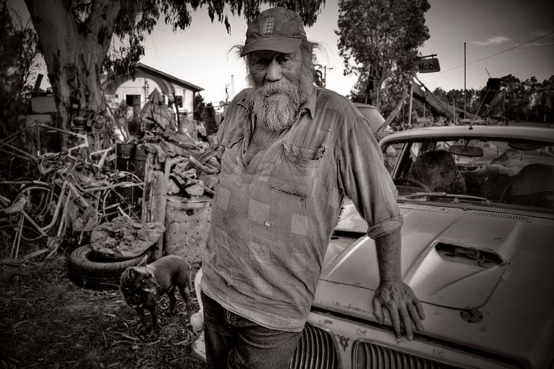
'Mobil Dave' ... from the Seldom Seen Roadhouse is a 'Man from the Snowy River'. If you haven't been to the Road House before, you will find Dave's collection of bikes fascinating and his mummified Kangaroos most interesting. Could I suggest that you ask Mobil Dave to show you how he feeds his chooks. Take your camera.
The road in from Delegate is through very pleasant country but do be warned, there are no shortages of logging trucks east of Delegate and they absolutely hammer.
Here is another tip. If you are going to have a major mechanical, around Tubbut, Deddick, Dellicnora or Delegate on these wonderful roads, make sure you have a mechanical right outside the Deddick Isolated Women's Group meeting hall. Last time I faked a puncture in front of the hall, it was nearly 2 weeks before they let me leave.
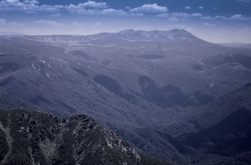
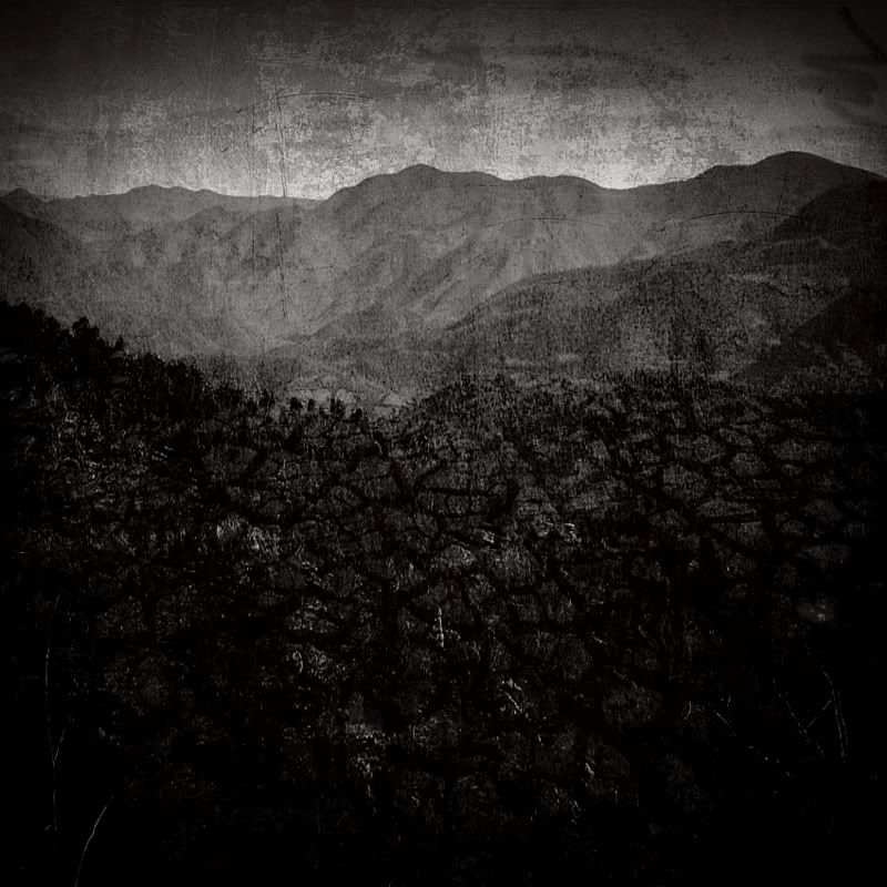
An accurate 'Map to the Byadbo' ... Wilderness. There are sharp quartzite ridges in the Byadbo.
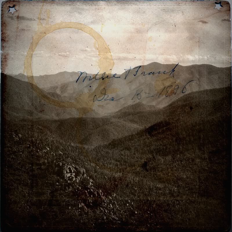
'My Life Among Cannibals' ... involved some charcoal roasting. I went up to the old stock yards on the Charcoal Range and couldn't find them. There is a track coming in from the Pilot Wilderness side, it is across the top of the ridge but I wasn't that bright. Do you know the term push bike ... it is a true term for here. Millie and Frank were taken by cannibals back is '96 touring somewhere up that way.
'More Charcoal' ... totally kick-arse country.
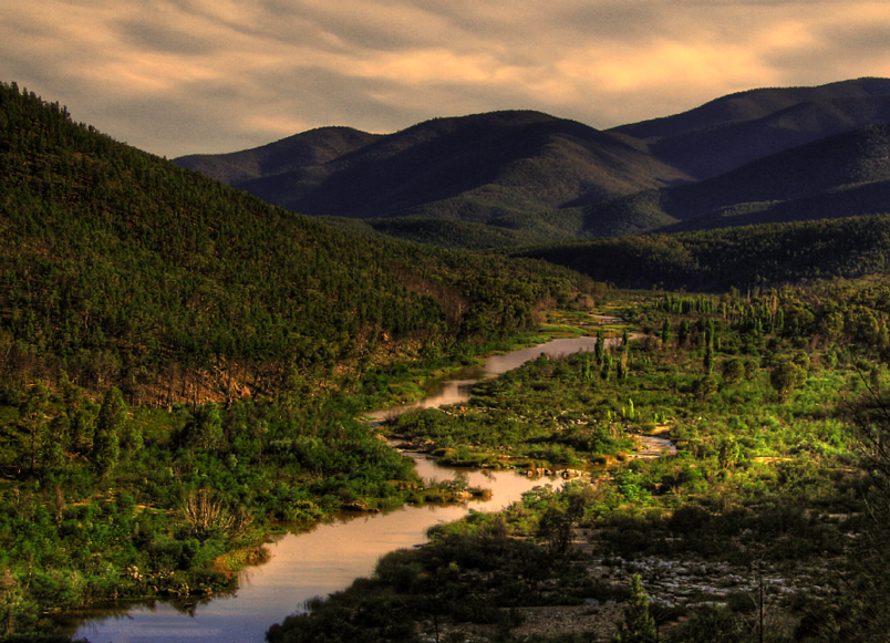
'Heading Down' ... to Suggan Buggan and Willis from the Galantipy Plateau. Going down, down. down, down, down ... then up, up, up, up, up, up,up ad infinitum.
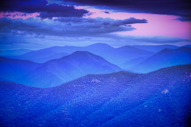
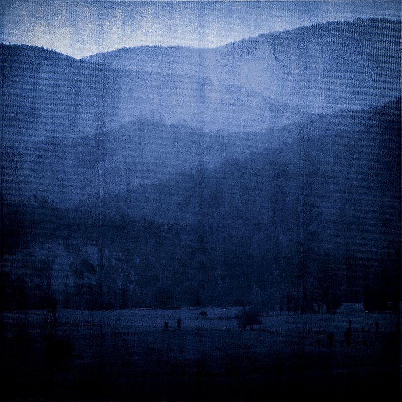
'The Once Mighty Snowy' ... looking back towards the 9 Mile Pinch.
Warren.
PS, Don't forget about riding slowly past the Isolated Women's Group Hall ... you might be the first man that they've seen in months.
"Paved roads ... another fine example of wasteful government spending." - a bumper sticker.
-
- Posts: 5
- Joined: Tue Jun 15, 2010 8:42 am
Re: Snowy Mountains foray
Postby wokka » Mon Jun 21, 2010 5:59 pm
Just a little more info. We're planning April school holidays next year (the backup crew include several kids).
The main question I have is the access to the Byadbo Wilderness from the snowy.
Google earth shows two different routes over. One is Sandy Creek Fire trail and the other is the Snowy Track. If we take the Sandy Creek F/T, we don't have to get up Tingi Ringi, and as some of group may not be as fit as they used to be AND we're all on the wrong side of 45ish, i'm assuming this may be the 'safer' option.
We're hoping to do a few reconnaissance trips before 'the big trip' in Spring, just to how UP is the UP.
Cheers
Warwick
- WarrenH
- Posts: 664
- Joined: Fri May 28, 2010 3:58 am
Re: Snowy Mountains foray
Postby WarrenH » Wed Jun 23, 2010 1:27 pm
I wasn't referring to Byadbo Mountain or the Byadbo Range but to the Byadbo Region. The Byadbo Wilderness is an area of approximately 3,000 square kilometres. What National Parks call a wilderness is only within a National Park. The western Byadbo overlaps the eastern edge of the Indi Wilderness (National Parks call Indi the Pilot Wilderness) How good are your maps? This is Byadbo;wokka wrote: ... is the access to the Byadbo Wilderness from the snowy.
Jeruselum Hill beside Purgatory Hill in NSW are the the highest peaks in the far NW of Byadbo. From Jeruselum Hill head N of NSE to Numbla Vale about 50 klicks away, which is approximately 20 kilometres south of Dalgety. Numbla Vale is the NE limit of Byadbo. Then travel 60 kilometres due south to the Delegate River, which is approximately level with the town of Bonang in Victoria. Then heading due west to Round Hill in the far SW of Byadbo. Round Hill overlooks Little River Gorge in Victoria. Then point your compass due North again over the Berima Range and you are back at Purgatory Hill about 65 kilometres from Little River Gorge. Within this rectangle lies Byadbo Mountain at the very centre of the Wilderness. The Byadbo Range is about 10 klicks south of Byadbo Mountain. You are even in Byadbo when you don't even know that you are there.
It is a very wise option. The Tingaringy Track from the Delegate River side is considered to be relatively good, tour vehicles go up there, unlike the two trails going south after Tingaringy Summit that both join to McKillop's Road they are difficult. In my photo of the blue ranges called 'Heading Down', the mountain in the centre on the horizon is Mount Tingaringy.wokka wrote:If we take the Sandy Creek F/T, we don't have to get up Tingiringi, ... I'm assuming this may be the 'safer' option.
The Sandy Creek Fire trail is a no-go for bikes because it is within the National Parks designated wilderness. Only the 9 Mile Pinch - Cascades - Tin Mines - Dead Horse Gap Track is open to bikes. If you go from Barry Way up the Pinch (also known as Moyangul) you will know why the horse died ... see again il padrone's photos.
There isn't a bridge at the end of the Sandy Creek Fire Trail crossing the Snowy, below Mount Trooper. It is a wet crossing. It was an old travelling stock crossing at times of low water levels which was seasonal because the Snowy was once, one of the World's great roaring alpine rivers. If the water is up you will not make it across the Snowy. Currently at sandy creek crossing it is over a metre deep. If the river is flowing at only 3 or 4 knots no one will get across. I've looked at the crossing on several occasions from the Barry Way side and the water has been to-up for me to even consider going. It is a fire trail, National Parks' 4x4 can make it across, when the water is low, like half way up the door. Brett McClelend is the Park Ranger in charge of the Southern Kosci' region, his number is (02) 64505600. He said that currently the water level is over the 4X4's bonnet.
I had imagined that your trip was going to be the easier route past McKillop's Bridge and Wulgumerang. I hope that when I called the Byadbo, "Byadbo" that finding Byadbo Mountain or the Byadbo Range, didn't distract you from your original route.
Warren.
"Paved roads ... another fine example of wasteful government spending." - a bumper sticker.
-
- Posts: 5
- Joined: Tue Jun 15, 2010 8:42 am
Re: Snowy Mountains foray
Postby wokka » Thu Jun 24, 2010 9:37 am
Thanks for all the invaluable information. It's a great pity about the Sandy Creek Fire Trail. I was under the impression any fire trail was OK for bikes, but the single walking trails were no-go. I assume the snowy track is also no-go? It's also a bugger getting over the river. The last time I was in the area (many moons ago), there were lots of rocks to hop over carrying a bike.
Looking more and more difficult to head east
I was hoping not to have to hit the roads to get over at McKillops bridge. Nice country but not as good as the wilderness on a bike. We also end up traveling a long way south ( I don't want to end up in Orbost )
I notice you took off Brett's phone number (which is good, he probably doesn't need it to be sent all over the world ), but do you have direct email for him? It would be good to get my options sorted out early.
Cheers and thanks again!
Warwick
- WarrenH
- Posts: 664
- Joined: Fri May 28, 2010 3:58 am
Re: Snowy Mountains foray
Postby WarrenH » Thu Jun 24, 2010 11:21 am
I know exactly what you mean, about the confusion related to cycling on fire trails. Whether a fire trail is a fire trail or a not permitted track or permitted multi-use trail (like the BNT) or a walking track. It is generally OK to cycle on fire trails except within National Parks declared wilderness zones and on NP temporarily closed trails. The fines are huge and can range from between $2300 on a walking track at place like Royal (if you know Royal there are walking tracks and single tracks for riding) to fines as much as $11,000 in a wilderness catchment like Kanangra-Boyd ... one doesn't want to get positioning their bike wrong. I don't know what the fines are at Kosci' I should check. It might pay to check.
If we want to tour we are basically forced to ride on roads and on fire trails with speeding back country drivers over Easter, they are making dust.
What about riding into Jagungal over Easter. Starting from the Naas Valley in the Southern ACT, riding on the Bicentennial National Trail past the Clear Range and the Booth Range across the frost plains of Northern Kosciusko down past Tantangra going along Farm Ridge through the Jagungal Wilderness and coming out at Island Bend. You would need the Bicentennial National Trail Guide Book # 10 'Jenolan Caves to Kosciuszko'. You need the guide book because staying on the trail can be tricky.
It is pretty specy country, from Round Mountain looking over Farm Ridge to Jagungal. A stunning place to tour on a mountain bike.
Warren.
PS, A post by Cliff Stables ... http://www.crazyguyonabike.com/doc/?o=R ... =3101&v=F7 ... and a quote, "A lovely campsite at Jacobs River. The Jacobs River runs next to the camp site. At the end of the day I laid face down in the shallow sandy bottomed river and let the cool water run over my back. The trip was worth it just for this experience."
"Paved roads ... another fine example of wasteful government spending." - a bumper sticker.
-
- Posts: 5
- Joined: Tue Jun 15, 2010 8:42 am
Re: Snowy Mountains foray
Postby wokka » Sun Jun 27, 2010 9:24 pm
The alternatives sound great but they are not what the ride is about. The ride is a sort of 'celebration' of my 50th birthday.
As I was born and bred in Bega but now live in the blue mountains, I thought it would be good to return to my birthplace again. We also travel yearly to a campsite near Tathra that holds a lot of great memories for me. So all this lead me to the idea of a ride from the top of Australia to the coast where I was born. Looking at maps etc, it all looks pretty doable but as usual 'the devils in the detail'. We are a bunch of guys that get out once or twice a week to hit the trails and enjoys our backyard for a few hours. What better way to motivate a few people to get fitter than to give them a challenge that is both healthy, inspiring, interesting, beautiful and meaningfull (at least to me)? I've even got a few people that want to join the trip, but they are going to have to buy a bike.
Hopefully I'll find time to contact the national parks this week, just to check the trails, and confirm which ones we can ride on.
I know there is a mountain bike race from Kosciuszko to Bermagui, but I believe it goes over several private properties.
We have also decided to travel a few weeks prior to Easter. Lots of 'animals' seem to come out camping over Easter....
Thanks again for your help and enthusiasm
Cheers
Warwick
- WarrenH
- Posts: 664
- Joined: Fri May 28, 2010 3:58 am
Re: Snowy Mountains foray
Postby WarrenH » Mon Jun 28, 2010 9:23 am
Warren.
"Paved roads ... another fine example of wasteful government spending." - a bumper sticker.
-
- Posts: 5
- Joined: Tue Jun 15, 2010 8:42 am
Re: Snowy Mountains foray
Postby wokka » Mon Jun 28, 2010 10:16 am
I wouldn't know which way to jump.
I just have to pull my finger out and contact the relevant authorities and/or look at my alternatives.
Cheers
Warwick
-
- Posts: 6
- Joined: Mon Apr 09, 2012 10:29 am
Re: Snowy Mountains foray
Postby Peteandian » Mon Apr 09, 2012 12:49 pm
The road was rough in places but completely do-able on road bikes with tough tyres (as long as it is dry).
- General Australian Cycling Topics
- Info / announcements
- Buying a bike / parts
- General Cycling Discussion
- The Bike Shed
- Cycling Health
- Cycling Safety and Advocacy
- Women's Cycling
- Bike & Gear Reviews
- Cycling Trade
- Stolen Bikes
- Bicycle FAQs
- The Market Place
- Member to Member Bike and Gear Sales
- Want to Buy, Group Buy, Swap
- My Bikes or Gear Elsewhere
- Serious Biking
- Audax / Randonneuring
- Retro biking
- Commuting
- MTB
- Recumbents
- Fixed Gear/ Single Speed
- Track
- Electric Bicycles
- Cyclocross and Gravel Grinding
- Dragsters / Lowriders / Cruisers
- Children's Bikes
- Cargo Bikes and Utility Cycling
- Road Racing
- Road Biking
- Training
- Time Trial
- Triathlon
- International and National Tours and Events
- Cycle Touring
- Touring Australia
- Touring Overseas
- Touring Bikes and Equipment
- Australia
- Western Australia
- New South Wales
- Queensland
- South Australia
- Victoria
- ACT
- Tasmania
- Northern Territory
- Country & Regional
Who is online
Users browsing this forum: No registered users
- All times are UTC+10:00
- Top
- Delete cookies
About the Australian Cycling Forums
The Australian Cycling Forums is a welcoming community where you can ask questions and talk about the type of bikes and cycling topics you like.
Bicycles Network Australia
Forum Information
Connect with BNA
This website uses affiliate links to retail platforms including ebay, amazon, proviz and ribble.