
Hi there.
I'm just planning some time in the Snowies and have bought a decent map, the Rooftops Kosciusko NP Forest Activities Map, to help me plot a route. Thought I might as well think about options while I have that triumvirate of juice, internet access and some time.
I'll be coming from the Albury direction and ending up in Jindabyne and, err, am pretty much prepared to walk the bike anywhere for a week or so.
Maybe in at Selwyn Snowfields, onto Tabletop Trail, onto Happy Jacks Road, Grey Mare Trail, Valentines Trail, Schlinks Trail, Guthega Road and out via the Snowy River Powerline Trail, or maybe not.
Anyone know what's possible up there, I see a little bicycle logo next to each of those tracks which makes me think it shouldn't be too much of a sweat. Yeah, that's a little joke.
GJ
Touring in the Snowy Mountains
-
GJ_Coop

- Posts: 119
- Joined: Fri Aug 12, 2011 4:57 pm
- Location: geez, I seem to be in NZ
- Contact:
-
WarrenH

- Posts: 664
- Joined: Fri May 28, 2010 3:58 am
Re: Touring in the Snowy Mountains
Hi there too Mate. You are able to hike-a-bike or (carry a bike) on walking trails in Kosci',to my understanding. I can certainly check that for you. I don't think that the NSW Cycling in NPs 2002 Act has been reviewed and amended yet. Likewise in the ACT you can hike-a-bike on walking trails.GJ_Coop wrote:Hi there.
Have you seen Graham Smith's crazyguy post Australian Alpine Tour ... http://www.crazyguyonabike.com/doc/?o=1 ... =9765&v=4N" onclick="window.open(this.href);return false; Much is covered in Graham's journal and recent.
There is much to see heading into Jagungal ... just don't camp too far below the inverted tree lines, too cold, even in summer.
If you're coming into the ACT, from down South, I'd be happy to suggest a route, that I'm sure would suit an explorer.
Warren.
Last edited by WarrenH on Sun Nov 25, 2012 6:53 pm, edited 4 times in total.
"But on steep descending...Larson TT have bad effect on the mind of a rider" - MadRider from Suji, Korea 2001.
"Paved roads ... another fine example of wasteful government spending." - a bumper sticker.
"Paved roads ... another fine example of wasteful government spending." - a bumper sticker.
-
il padrone

- Posts: 22931
- Joined: Mon Apr 07, 2008 11:57 pm
- Location: Heading for home.
Re: Touring in the Snowy Mountains
There was a contentious attempt to significantly restrict MTB access to trails in the Snowy Mountains NP by a NSW Parks review a couple of years ago. This would have made the Grey Mare Trail to Schlink Pass and Guthega 'no bikes', and same for the Cascades Fire Trail beyond Cascades Hut. All these trails are management vehicle 4WD tracks so bicycle-induced trail erosion is really a furphy. Happily it seems these restrictions have been lifted, going by this 2012 publication from Environment NSW (see the last page especially). Should be a very useful reference for you.
Grey Mare/Valentines through the Jagungal Wilderness Zone are all OK. Same for Cascade Fire Trail, Ingeegoodbee Trail and the Nine Mile Pinch through the Cascade Wilderness Zone (though I'd recommend against doing the Nine Mile fully-loaded - >20% gradients ). If you want to ride from Charlottes Pass up Mt Kosciuszko you can only go as far as Rawsons Pass about a km below the summit, then you need to hoof it.
Grey Mare/Valentines through the Jagungal Wilderness Zone are all OK. Same for Cascade Fire Trail, Ingeegoodbee Trail and the Nine Mile Pinch through the Cascade Wilderness Zone (though I'd recommend against doing the Nine Mile fully-loaded - >20% gradients
Mandatory helmet law?
"An unjustified and unethical imposition on a healthy activity."
"An unjustified and unethical imposition on a healthy activity."
-
GJ_Coop
- Posts: 119
- Joined: Fri Aug 12, 2011 4:57 pm
- Location: geez, I seem to be in NZ
- Contact:
Re: Touring in the Snowy Mountains
Wow. That was quite some response.
Pete: That pdf says there's really only a problem with access in the Jagungal Wilderness Zone but those tracks I mentioned are OK. Thanks for that reassurance, nice to know I won't have the rangers bearing down on me, for that at least.
I think I recall a photo or two of you and a group of mates rattling down 9 Mile Pinch somewhere. Looked like fun, well more fun going down than going up with a trailer.
Wuzza: Any hope of getting a short caption on those terrific images, that was kinda like I'd imagined.
I did look at Graham Smith's crazyguy post Australian Alpine Tour and it doesn't look quite like the 9 Mile images I saw. Quite doable, although if he took 2 days I'm sure I can stretch it out to 2 weeks.
The trip is supposed to be along the Murray River and this is just a little side venture, dunno if I can procrastinate much longer on my travels, gee, I have to finish one day, so haven't considered any further north of the Snowy Mountains Highway, at this stage.
Thanks team, I knew I could rely on youse.
By the way, does the park ever close due to fire danger, just asking, I know that in December/January that rain is more likely.
GJ
-
il padrone
- Posts: 22931
- Joined: Mon Apr 07, 2008 11:57 pm
- Location: Heading for home.
Re: Touring in the Snowy Mountains
When we went down the Nine Mile it took us about 2 hours to travel something like 9kms. The main descent drops 900m in 4.5kms (ie. 20% average) but there is some climbing in there too. Off the water-bars, which were HUGE, the gradient steepens to over 30% I reckon.

Technique for the Nine Mile - sit on the top tube, one foot down and sliding, allows you to skid both wheels and not fall over. Also ensures you keep the bike in-line, rather than having the problem of rear wheel trying to overtake the front if you try to walk.

Technique for the Nine Mile - sit on the top tube, one foot down and sliding, allows you to skid both wheels and not fall over. Also ensures you keep the bike in-line, rather than having the problem of rear wheel trying to overtake the front if you try to walk.
Mandatory helmet law?
"An unjustified and unethical imposition on a healthy activity."
"An unjustified and unethical imposition on a healthy activity."
-
WarrenH
- Posts: 664
- Joined: Fri May 28, 2010 3:58 am
Re: Touring in the Snowy Mountains
GJC, on the Northern side of the Murray during Summer, the remote tracks from Bowna Road to Lankeys Creek are closed in Woomargama National Park and in the State Forests and Reserves due to the isolated nature of the trails and the risk posed by fire.... does the park ever close due to fire danger, just asking, I know that in December/January that rain is more likely.
Kosciuszko NP, has a web page about fires, floods and closures ... http://www.environment.nsw.gov.au/Natio ... x?id=N0018" onclick="window.open(this.href);return false; If this site is shown as Service Unavailable, it is being updated. Call back.
In NSW there is also Live Traffic NSW ... http://livetraffic.rta.nsw.gov.au/desktop.html" onclick="window.open(this.href);return false;
If you need KNP info, this is the direct number to Jindabyne ... 02 64505600.
As far as wheeling the bike on walking tracks goes, cycling isn't allowed on walking tracks but in the new 2011 NSW NP&WS Cycling Policy consistent with the original 1974 policy, Cycling is defined as riding a bicycle in any style. National Parks will clarify that within the next few hours, they're confused as to what is cycling. They think that pushing a bike is cycling. I'll let you know what the NSW NP&WS Kosciuszko's Senior Ranger's decision is, as soon as I know ... http://www.environment.nsw.gov.au/resou ... ycling.pdf" onclick="window.open(this.href);return false;
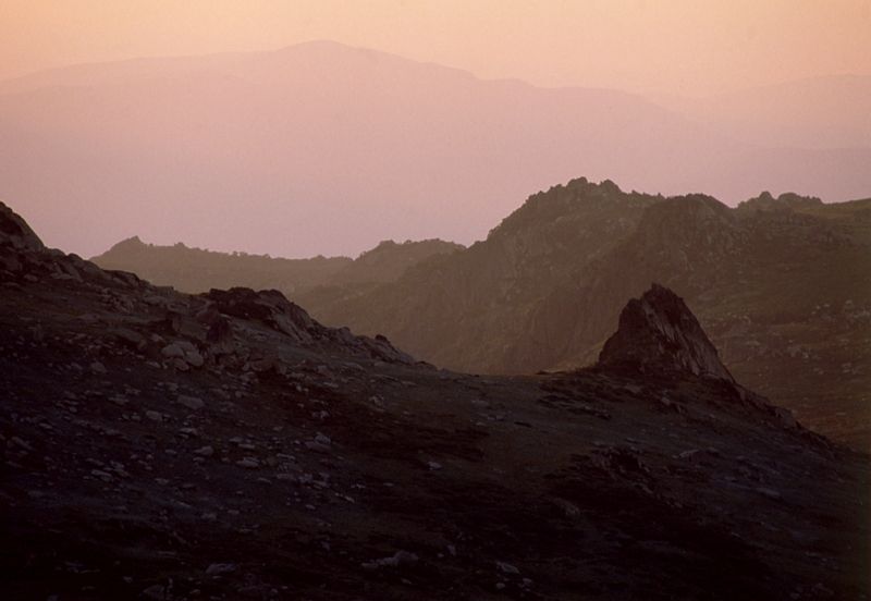
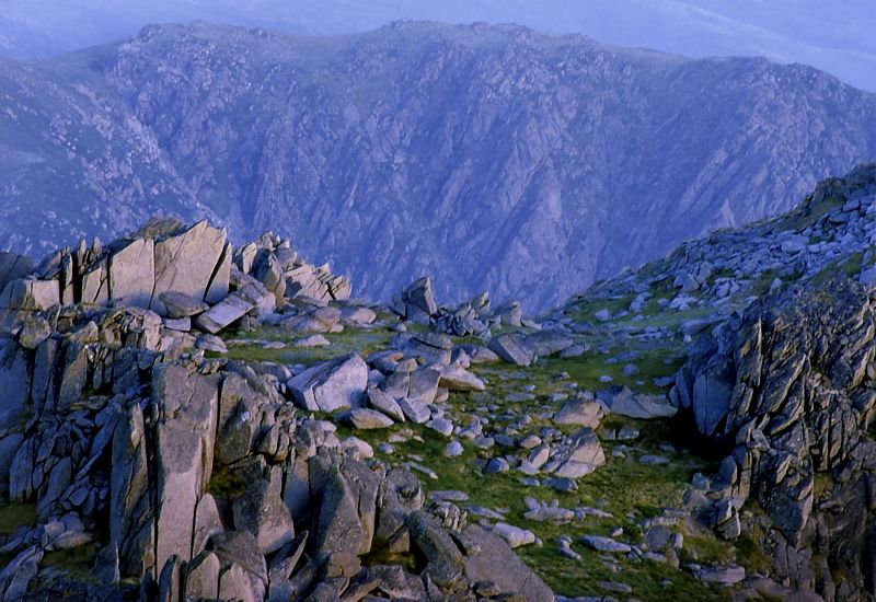
The first photo above, is from the track across the Main Range, shot from above Lady Northcote Canyon looking into Victoria. The smokey mountain in the distance is Mount Pinnabar.... a short caption
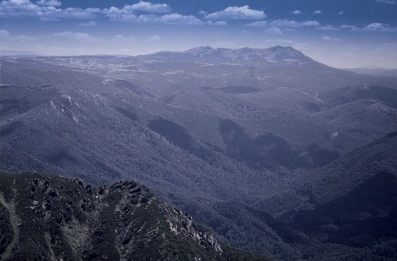
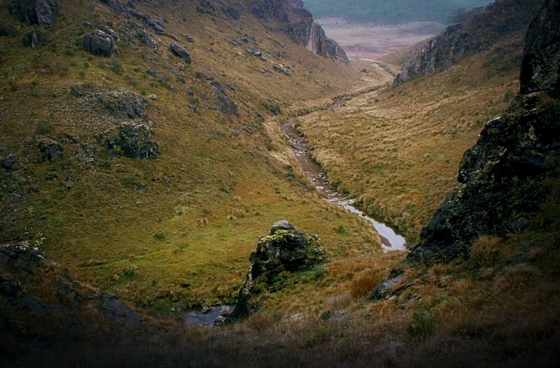
The second shot is of Mount Jagungal, from near the Round Mountain Fire Trail. The valley is the headwaters of the Tumut River. The main ridge on the left is Farm Ridge.
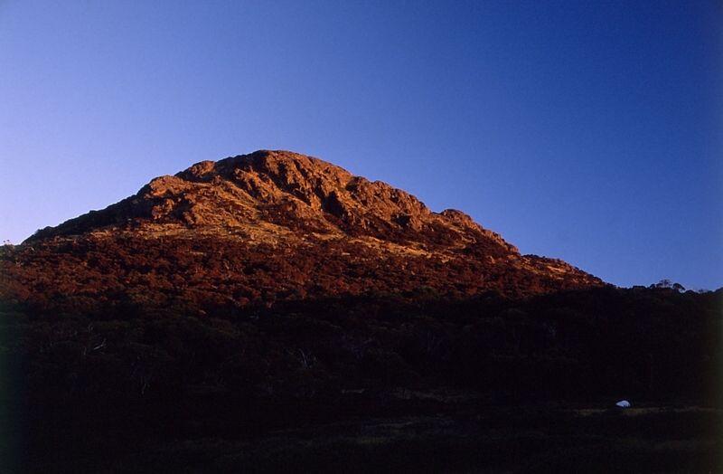
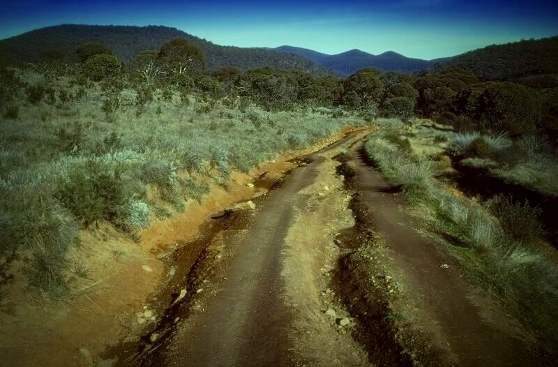
The third image is, my tent below Mount Jagungal. I was camped near Pugilistic Creek. Jagungal is a good climb with fantastic views of the Western Face of the Main Range (now called the Western Fall Wilderness).
Another good area for wandering is The Ramshead Range. If you ride into Mount Kosci' on the Summit Road from Charlottes Pass, the track starts at Rawson Pass on Ethridge Ridge.
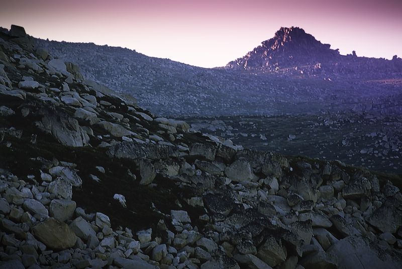
Watsons Crags from the Mullers Peak Track.
Warren.
Last edited by WarrenH on Tue Nov 27, 2012 9:19 am, edited 5 times in total.
"But on steep descending...Larson TT have bad effect on the mind of a rider" - MadRider from Suji, Korea 2001.
"Paved roads ... another fine example of wasteful government spending." - a bumper sticker.
"Paved roads ... another fine example of wasteful government spending." - a bumper sticker.
-
WarrenH
- Posts: 664
- Joined: Fri May 28, 2010 3:58 am
Re: Touring in the Snowy Mountains
GJC, National Parks were prompt in their reply and have agreed that pushing a bike is not cycling. There's no restrictions to pushing or carrying a bike now on walking tracks within Kosciuszko National Park.
Bikes can also be taken on the chairlift from Thredbo and wheeled on the metal walkway through the Ramshead Range to Rawson Pass.
The track across the Main Range is rough in places and it would be difficult at times. There are ice caves in the drifts, like the Cootapatamba Drift and the South American Drift. Ice caves are good places to have lunch when the bush flies get too irritating.
Enjoy your time in the Alps.
Warren.
"But on steep descending...Larson TT have bad effect on the mind of a rider" - MadRider from Suji, Korea 2001.
"Paved roads ... another fine example of wasteful government spending." - a bumper sticker.
"Paved roads ... another fine example of wasteful government spending." - a bumper sticker.
-
Vintagetourer
- Posts: 240
- Joined: Sat Aug 22, 2009 12:17 pm
- Location: Canberra
Re: Touring in the Snowy Mountains
This is a link to a thumbnail overview of the permissible cycling trails. Handy to get the big picture.
http://www.crazyguyonabike.com/doc/page ... id=1133709" onclick="window.open(this.href);return false;
The above posts have pretty much nailed the main options.
When I was young and sillier, I rode from Tom Groggin to Berridale via Dead Horse Gap in a day. The first bit is supposedly Australia's biggest hill climb. If not, it felt like it with a loaded bike.
Just about everywhere in KNP is wonderful. On my wishlist is from Deadhorse Gap to the Barry Way via Cascade Trail and Nine Mile. I've walked a fair bit of it and would like to ride it some day.
Or in the same area, through to Carters Hut and Tin Mines is pretty special.
gs
-
WarrenH
- Posts: 664
- Joined: Fri May 28, 2010 3:58 am
Re: Touring in the Snowy Mountains
Graham, cycling is also allowed on the Bicentennial National Trail. Further to the map, would included the Geehi Walls Fire Trail. The track from Bradneys Gap to Jagumba ... which is the Murray Powerline Track.Vintagetourer wrote:This is a link to a thumbnail overview of the permissible cycling trails. Handy to get the big picture.
Blackjack Fire Trail. Manjar Fire trail. The Fifteen Mile Ridge track and the Tolbar Trail.
Cycling is allowed on all the fire trails North of Lake Eucumbene, untill reaching the ACT Border adjacent to the Bimberi Wilderness. In the Bimberi Wilderness, they are hike-a-bike trails.
Warren.
"But on steep descending...Larson TT have bad effect on the mind of a rider" - MadRider from Suji, Korea 2001.
"Paved roads ... another fine example of wasteful government spending." - a bumper sticker.
"Paved roads ... another fine example of wasteful government spending." - a bumper sticker.
-
WarrenH
- Posts: 664
- Joined: Fri May 28, 2010 3:58 am
Re: Touring in the Snowy Mountains
Cycling is also allowed on the Bicentennial National Trail, which the map isn't showing. This is most odd.Vintagetourer wrote:This is a link to a thumbnail overview of the permissible cycling trails. Handy to get the big picture.
Within the map area and not shown, should be included the Geehi Walls Fire Trail. The track from Bradneys Gap to Jagumba ... which is the Yellow Bog Track and the Upper Murray Powerline Track. Blackjack Fire Trail. Manjar Fire Trail (Blackjack fire tower to Manjar is cool, it's difficult with spectacular views of the Western Fall Wilderness). The Fifteen Mile Ridge Track, Happy Jacks and the Tolbar trails. These trails are all open to cycling.
Cycling in KNP is also allowed on the fire trails North of Lake Eucumbene, terminating at the ACT Border, where KNP is adjacent to the Bimberi Wilderness. In the Bimberi Wilderness, the tracks are hike-a-bike trails.
Blue Water Holes Fire Trail crossing Caves Creek and Leura Gap Fire Trail looking towards Leura Gap. Leura Gap Fire Trail joins the northern end of Pockets (Saddle) Fire Trail.
Warren.
"But on steep descending...Larson TT have bad effect on the mind of a rider" - MadRider from Suji, Korea 2001.
"Paved roads ... another fine example of wasteful government spending." - a bumper sticker.
"Paved roads ... another fine example of wasteful government spending." - a bumper sticker.
Who is online
Users browsing this forum: No registered users