Thanks for a great write-up and reflections. Some comments, comparing your trip to ours just before Christmas (Junee to Bairnsdale via Thredbo, Benambra):
> In summer be prepared for rivers that are otherwise flowing to be stagnant if the summer temperatures soar. We were carrying about 10L for two people and had water issues a couple of times. On the flip side, when water was available we just used iodine tablets and never boiled water and it worked out fine for us.
We didn't run into this problem at all - I guess the difference between early and late summer. Although the weather was scorching, all rivers were flowing strongly, and had plenty of water in all the creeks through the Jagungal area in particular. A lifesaver!
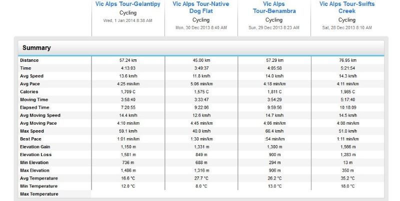
> Its hard to avoid the heat!!! It was upwards of 35C for much of the trip, which combined with the climbing made for some overwhelmingly hot days. We were out by 6:30 most days but still had trouble getting where we were going without riding through the hottest times of the day. We found it psychologically difficult to sit around not riding for 3-4 hours during the day when it was really hot, as you kind of feel like keeping on moving and getting there. We hit the electrolyte drinks pretty hard, which helped a lot:)
We didn't quite manage to get up so early, but did sit out a couple of really hot periods, in Talbingo, Cabramurra and Thredbo. Probably a lot easier when you're in a town with aircon.

> careful of possums!! At jacob's river along Barry's way we had a possum having a go at our food supply, so had to move it inside the tent. later in the night while trying to sleep, I saw a flashlight in the area. It's very remote there and I started getting a bit paranoid. It was closeby, but flashing around haphazardly, and I wondered who on earth would be there at midnight. Eventually it stopped just near our tent, on but not moving, and I heard a possum running away. I went out to find my bikelight nearby with possum bites in it! The little bugger had somehow detached it from my bike (which is not easy even for human hands), played with the switch, turned it on, freaked us out and then gotten bored. The moral of the story is that anything, no matter how inedible, is up for grabs if left out at night.
Good to know. We're planning a trip down this way in April.
> Huts are the way to go. We only stayed in the one at Geehi, but would plan for more in future.
Yeah, huts are awesome. So many in Kosciu NP. Only problem with cycletouring is you tend to move too fast to get to stay at many. We stayed at Dershko's and Seaman's.
> - research rail trails beforehand and make sure and use them - it's worth planning a trip around them.
Check out
http://railtrails.org.au" onclick="window.open(this.href);return false; or
http://cycletour.org" onclick="window.open(this.href);return false;
> - Don't bother with a map unless you're going offroad. We used the rooftop maps, but it was largely unnecessary as the maps from info places are usually sufficient, and have extra local information on them, plus tend to be smaller, simpler to read and you don't worry about destroying a $12 map. On the other hand, topographical information is important, and in future I'd learn about where the major climbs will be - we had a few surprises!!
What I did on this trip was print out screenshots from cycletour.org on A3 paper, roughly 1 per day. It was so convenient being able to pull out a map from my shirtpocket, not worry about it being sweaty etc. Much more convenient than a commercial printed map.
Steve