
Questions to those who cycled in Europe.
Did you use paper maps?
Did you use some special 'bicycle maps'?If so, which ones?
Did you use a gps?
Did you just take paper maps and plan the journey as you go?
What worked and what didn't?
What would you do differently in terms of navigation?
Also, how difficult was it to find a free place to camp? I generally just camp in random spots, parks, churches, football fields etc but would think in Europe this could be more tricky?
I never cycled in such a busy and populated area, never used a gps in my previous trips. Just local paper maps. I dont really use any fancy phones or other electrical devices but thinking maybe a gps would be needed in Europe?
Ta : )
Traveling Europe - maps/gps. What would you use?
-
polishbiker
- Posts: 371
- Joined: Sat Oct 02, 2010 10:18 am
-
il padrone

- Posts: 22931
- Joined: Mon Apr 07, 2008 11:57 pm
- Location: Heading for home.
Re: Traveling Europe - maps/gps. What would you use?
I bought paper maps here for planning pre-trip. Then left them behind because of concerns about going overweight 
 I also had the Garmin City Navigator Europe map, and the Mapswithme off-line maps (on the mobile) for Italy and Corsica. Once in Italy we wound up buying the local road maps for regions we travelled through (ITER, Michelin & IGN). These came home with us and were now a duplicate set, so I donated a set of maps to our touring club.
The paper maps were essential for longer distance planning, usually in hotel rooms - I rarely took them out when on the road. We used Mapswithme for checking route options and nearby localities on the road, while the GPS was invaluable for navigating our way into and out of busy, unfamiliar Italian towns and cities as well as 'on the bars' route checking.
You would not go wrong with a paper map, but a GPS was a great help with finding our way through at times confusing local streets and signs.
We went with a very general plan of the places we wanted to travel to, and some specific routes. We only booked our first three nights in a hotel in Rome then bought train tickets, booked hotel rooms or organised campsites as we went. It was April-July so mostly out of the peak season. In Italy we rarely camped and only did a bush/stealth camp twice. Commercial camping at caravan parks was a culture shock - BYO toilet paper, dunnies with no seat, few camp kitchens, no hot water for dish-washing nor in hand basins - and the prices were not very cheap. When you're paying 20-25 Euro for an unpowered site for two and there is no hot water to wash dishes and BYO dunny paper, you begin to wonder why?? The best camping ground we stayed in was the Rosselbe di Palma on Elba, but the 50 Euro tarriff was steep - lovely place to stay with great facilities (but still a gravel campsite). Coupled with this most camping grounds were generally 4-10kms from the nearest town by a beach. I did NOT go to Italy to see beaches (plenty of great beaches here), but DID want to see and experience the wonderful medieval towns, so we stayed in 3-star hotels a lot of the time, usually as close to the 'centro storico' as we could get. This allowed us to lock up our bikes securely in the hotel store-room or garage for our stay and wander about the centro storico on foot without worries about bike theft.
We were also told by some that, certainly in southern Italy, stealth camping is frowned upon. Really there is not a lot of truly unoccupied land. I believe that France and northern Europe is quite different for camping - campsites in most towns and even small villages, fairly cheap, and often very close to city centres. You will be OK in organised camps here - don't know about stealth camping. BTW, for camping a really good option (to save weight on the flight) is to leave your stove and other kitchen gear at home and buy a Camping-gaz stove and canister and plates/cutlery when you get there. Get the puncture canisters, they are really cheap and available in almost every supermarket and town grocer shop.
I'm very envious - would love to be going back. Treatment by traffic in Italy was really fantastic. The quieter Strade Provinciale roads were really nice to ride along. Have a great time.
Rosselbe di Palma, Isola d'Elba


Mandatory helmet law?
"An unjustified and unethical imposition on a healthy activity."
"An unjustified and unethical imposition on a healthy activity."
-
polishbiker
- Posts: 371
- Joined: Sat Oct 02, 2010 10:18 am
Re: Traveling Europe - maps/gps. What would you use?
Ok, can you suggest a suitable route Mr?
If i get everything organized i would like to leave sometime in July this year until November/December.
Will be traveling by a bicycle with all sleeping/cooking equipment.
Would prefer if the temps were not minus.
Been reading articles and looking at google maps but would like peoples input.
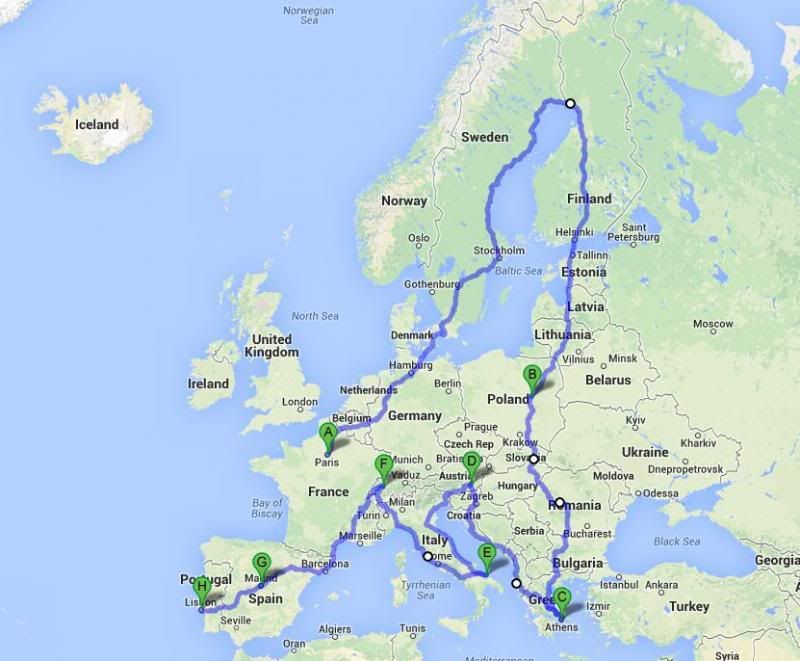
Was thinking something like:
land in Paris, cycle North through the coast belgium/germany/holland/denmark/norway/sweden
then south via finland/poland, maybe via romania/bulgaria/greece
then North and South via austria/italy/swistzerland/spain and maybe finish in portugal?
If i get everything organized i would like to leave sometime in July this year until November/December.
Will be traveling by a bicycle with all sleeping/cooking equipment.
Would prefer if the temps were not minus.
Been reading articles and looking at google maps but would like peoples input.
Was thinking something like:
land in Paris, cycle North through the coast belgium/germany/holland/denmark/norway/sweden
then south via finland/poland, maybe via romania/bulgaria/greece
then North and South via austria/italy/swistzerland/spain and maybe finish in portugal?
-
il padrone
- Posts: 22931
- Joined: Mon Apr 07, 2008 11:57 pm
- Location: Heading for home.
Re: Traveling Europe - maps/gps. What would you use?
You'll need six months for that journey!
I presume that you have an EU passport, to overstay the Schengen visa 90 days limit?
Our experience with 3 months, just in Italy and Corsica, was that we ran out of time, due to there being so many places to stop and things to see. When cycling we were generally riding 60-70km days, but there was still so many lovely villages and scenery to take in along the way; and then there were the highlight towns and cities every couple of days that demanded a day to explore (just a bit). Europe is not a place to cycle on a destination-based, speed record setting tour. There are far to many 'roses to smell'.
Last edited by il padrone on Fri Apr 25, 2014 1:09 pm, edited 1 time in total.
Mandatory helmet law?
"An unjustified and unethical imposition on a healthy activity."
"An unjustified and unethical imposition on a healthy activity."
-
RonK

- Posts: 11508
- Joined: Mon Aug 24, 2009 2:08 pm
- Location: If you need to know, ask me
- Contact:
Traveling Europe - maps/gps. What would you use?
Sounds like a plan. Have you looked at the Eurovelo routes? I think they'll have most of that mapped.
Eurovelo
Eurovelo
Cycle touring blog and tour journals: whispering wheels...
-
il padrone
- Posts: 22931
- Joined: Mon Apr 07, 2008 11:57 pm
- Location: Heading for home.
Re: Traveling Europe - maps/gps. What would you use?

Mandatory helmet law?
"An unjustified and unethical imposition on a healthy activity."
"An unjustified and unethical imposition on a healthy activity."
-
polishbiker
- Posts: 371
- Joined: Sat Oct 02, 2010 10:18 am
Re: Traveling Europe - maps/gps. What would you use?
Yes, the above google map was just a rough idea, i been creating a better more detailed route based on eurovelo website.
Only conecern is the weather to be honest, but from my understanding if i am around Poland and more south by September/October and head towards Italy/France/Spain by November/December it woudl work without any snow or really cold temperatures?
And yes, i do have a polish passport too : )
Only conecern is the weather to be honest, but from my understanding if i am around Poland and more south by September/October and head towards Italy/France/Spain by November/December it woudl work without any snow or really cold temperatures?
And yes, i do have a polish passport too : )
-
rama
- Posts: 67
- Joined: Fri Apr 23, 2010 6:45 pm
Re: Traveling Europe - maps/gps. What would you use?
Pawel, notify me in advance when you make it to Greece, to assist in terms of accommodation.
I can also set you up for a major bike service in Athens.
You may also contact me through our local forum http://www.cyclist-friends.gr/forum.php" onclick="window.open(this.href);return false; (I use the same nickname).
Don't forget to time your July start in France to coincide with the Tour!
Also bear in mind you can catch a ferry from western Greece to various ports along the east coast of Italy (Bari, Brindisi, Ancona, Venice).
Last edited by rama on Fri Apr 25, 2014 9:37 pm, edited 1 time in total.
-
RonK
- Posts: 11508
- Joined: Mon Aug 24, 2009 2:08 pm
- Location: If you need to know, ask me
- Contact:
Re: Traveling Europe - maps/gps. What would you use?
I watched the Arctic tour last year and was entranced by Norway's stunning landscapes. But I think the weather window for touring so far north is small. The tour is in August but even then the weather was quite variable.
Likewise I think you would probably want to have any alpine crossings done and be clear of the mountains by November.
Likewise I think you would probably want to have any alpine crossings done and be clear of the mountains by November.
Cycle touring blog and tour journals: whispering wheels...
-
jemo27
- Posts: 110
- Joined: Wed Aug 25, 2010 10:20 am
Re: Traveling Europe - maps/gps. What would you use?
I used paper maps in France and Belgium last year really easy to use except in cities where I got lost sometimes find my way. I took my iPad mini and used free wifi which was in nearly every town for free.
I'm off on a 5 month cycling trip in North America and I planning on getting maps of cities before I arrive because I found that the hardest things was getting lost trying to find the tourist information centre to then get a map.
In terms of free camping I found France really hard because they don't really have show grounds or parks like we do in Australia or UK. I found often that sports grounds I did find, like football pitches, were fenced off. I still camped for free more than I paid to camp. Depends where you are going and how confident you are with stealth camping.
French toilets we such a contrast, in some towns it would be easy to find while in other towns they would be hidden and what type of toilet changed from what we have in Australia to just basically a hole in the ground where you squat. I agree with the lack of toilet paper in camp grounds too.
Have you heard of Warmshowers, really useful in not only free accommodation but also getting local advice about cycling routes. I often email people first on Warmshowers asking about their local area.
How many kms are you planning on doing in 6 months, I did 5000kms in 3 months yet I barely felt I got to know France, England or Belgium. My advice is concentrate on a certain area rather than trying to see all of Europe in one go. It's not like Australia where you can cycle 50kms or more between towns, often you will leave one town and be able to see the next one at the same time. There is a lot of suburban cycling rather than open road cycling. Remember countries like France or Germany have a much bigger population than Australia but smaller land mass. Try to avoid built up areas, it can feel like cities just join up together. I found it repetitive sometimes just going through villages constantly rather than like in Australia where you may only see a few towns each day.
Is there anything in particular that you want to see while cycle touring?
Keep asking questions
-
RonK
- Posts: 11508
- Joined: Mon Aug 24, 2009 2:08 pm
- Location: If you need to know, ask me
- Contact:
Re: Traveling Europe - maps/gps. What would you use?
Since you have an iPad Mini why don't you just get the MapsWithMe app?jemo27 wrote:I used paper maps in France and Belgium last year really easy to use except in cities where I got lost sometimes find my way. I took my iPad mini and used free wifi which was in nearly every town for free.
I'm off on a 5 month cycling trip in North America and I planning on getting maps of cities before I arrive because I found that the hardest things was getting lost trying to find the tourist information centre to then get a map.
Cycle touring blog and tour journals: whispering wheels...
-
polishbiker
- Posts: 371
- Joined: Sat Oct 02, 2010 10:18 am
Re: Traveling Europe - maps/gps. What would you use?
jemo, where abouts in N America are you going? I can give you my routes/excel waypoints from my alaska-canada trip last year. north america is quite easy when it comes to directions due to a lot of open roads i found.
i am pretty confident when it comes to camping, previously used warmshowers as well. thats my concern, i really like open roads hence cycling australia was great. europe to me is like "one big town" with traffic lights and people everywhere but i need to see some of my family in Poland so thought i would just cycle some of the europe, if it wasnt for my family i wouldnt be cycling europe anytime soon.
havent done backpacking in a few years so think i am out of practice now, used to cycling instead , or i simply decide to spend a month or so backpacking and not worry about cycling there.
nothing in particular, to me cycling touring is not so much about seeing all the main attractions, its more about being out there living simple life and meeting interesting people along the way.
in 6 months i can cover more than 10.000kms normally, could be different in heavily built up areas tho.
-
jemo27
- Posts: 110
- Joined: Wed Aug 25, 2010 10:20 am
Re: Traveling Europe - maps/gps. What would you use?
http://www.crazyguyonabike.com/doc/na2014" onclick="window.open(this.href);return false; is my journal, basically I will be cycling north from LA on an inland route to Vancouver then exploring southern BC and Alberta before making my way to Salt Lake City.polishbiker wrote:jemo, where abouts in N America are you going? I can give you my routes/excel waypoints from my alaska-canada trip last year. north america is quite easy when it comes to directions due to a lot of open roads i found.
i am pretty confident when it comes to camping, previously used warmshowers as well. thats my concern, i really like open roads hence cycling australia was great. europe to me is like "one big town" with traffic lights and people everywhere but i need to see some of my family in Poland so thought i would just cycle some of the europe, if it wasnt for my family i wouldnt be cycling europe anytime soon.
havent done backpacking in a few years so think i am out of practice now, used to cycling instead , or i simply decide to spend a month or so backpacking and not worry about cycling there.
nothing in particular, to me cycling touring is not so much about seeing all the main attractions, its more about being out there living simple life and meeting interesting people along the way.
in 6 months i can cover more than 10.000kms normally, could be different in heavily built up areas tho.
Feel free to share your experiences
Who is online
Users browsing this forum: No registered users