
Perhaps for everyone's sake can we post a list of cycle no-go or damaged roads due to the floods. Some of us are going stir-crazy!
Starting with: The Riverwalk!
Anyone ride Cootha lately?
Brisbane Flood Road Damage List
-
ValleyForge

- Posts: 1831
- Joined: Tue Jan 27, 2009 5:37 pm
- Location: Brisbane
Brisbane Flood Road Damage List
Ha ha ha! Cookies on dowels.
-
Max

- Posts: 2895
- Joined: Wed Jun 18, 2008 1:29 pm
- Location: Brisbane
- Contact:
Re: Brisbane Flood Road Damage List
My understanding is that portions of the Centenary Motorway are still underwater, particularly the area near the Jindalee bridge. I haven't heard any other first-person reports.
Max
Max
One of the best things about bicycle commuting is that it can mitigate the displeasure of having to go to work. - BikeSnobNYC
Cycling is sometimes like bobbing for apples in a bucket full of dicks. - SydGuy
Cycling is sometimes like bobbing for apples in a bucket full of dicks. - SydGuy
-
Rhubarb
- Posts: 964
- Joined: Sat Jan 16, 2010 9:42 pm
Re: Brisbane Flood Road Damage List
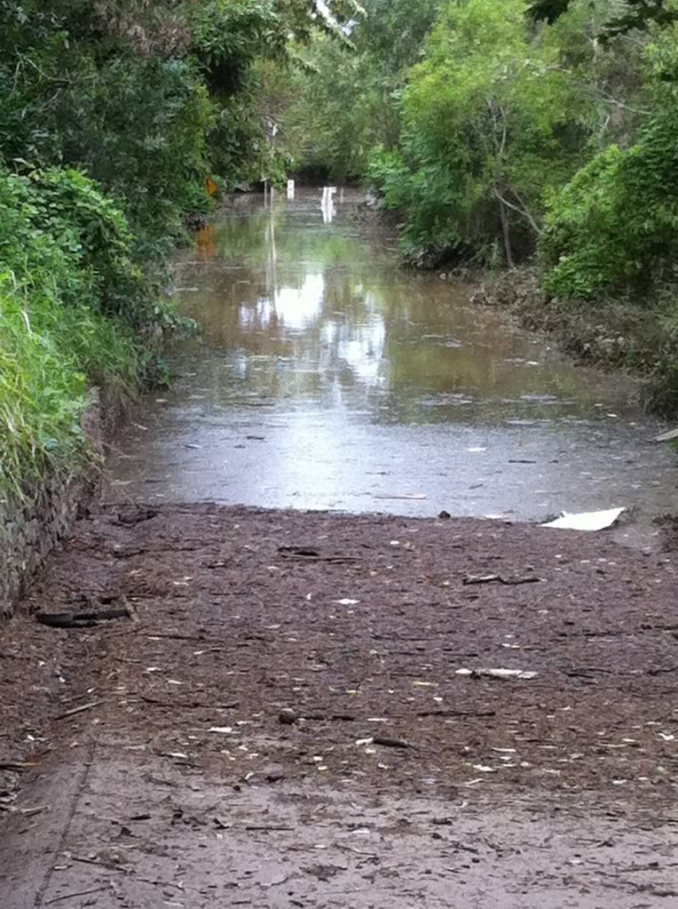
I rode in to Toowong this afternoon from Brookfield. The Western Freeway bikepath is closed at the Jindalee Bridge. Sylvan Road at Toowong is underwater at the railway bridge near Land St.
The biketrack is also underwater at Witton St, Indooroopilly. Here's a photo:
On the upside I passed the council street sweeper machine that has already cleaned up the non submerged parts of the western freeway biketrack. Pretty good given everything the council is dealing with at the moment.
The biketrack is also underwater at Witton St, Indooroopilly. Here's a photo:
On the upside I passed the council street sweeper machine that has already cleaned up the non submerged parts of the western freeway biketrack. Pretty good given everything the council is dealing with at the moment.
-
Max
- Posts: 2895
- Joined: Wed Jun 18, 2008 1:29 pm
- Location: Brisbane
- Contact:
Re: Brisbane Flood Road Damage List
The Ipswich Motorway, taken from the Blunder Rd roundabout:


Max
Max
One of the best things about bicycle commuting is that it can mitigate the displeasure of having to go to work. - BikeSnobNYC
Cycling is sometimes like bobbing for apples in a bucket full of dicks. - SydGuy
Cycling is sometimes like bobbing for apples in a bucket full of dicks. - SydGuy
-
Mustang

- Posts: 1572
- Joined: Tue Feb 02, 2010 9:20 am
- Location: Little Mountain Qld
- Contact:
Re: Brisbane Flood Road Damage List
Been watching it on TV, very hard to take in, one wonders about the waste of money to the Travis Dam (550million) as opposed to spending that money on Wivenhoe. 
Distance Goal 4000km
70 years young.
70 years young.
-
marinmomma
- Posts: 2039
- Joined: Mon Jul 26, 2010 2:12 pm
- Location: Southside Brisbane
Re: Brisbane Flood Road Damage List
If you can handle the bogan tradies trying to take you out (happened to me this morning!) Logan's ok...we rode the loop from Shailer Park down over Slacks Creek on Loganlea Rd then around and up Eden's Landing hill in through Beenleigh then back into Shailer via Loganholme/Hyperdome.
The Logan River was up as high or possibly higher than I've ever seen it in 20 years.
Potholes are many, as they are everywhere.
The Logan River was up as high or possibly higher than I've ever seen it in 20 years.
Potholes are many, as they are everywhere.
Lisa
-
BruceGray
- Posts: 114
- Joined: Fri Jan 07, 2011 11:31 pm
- Location: Brisbane
Re: Brisbane Flood Road Damage List
I've spent the last few days around Wavell Heights and Nundah, and decided to have a look at the river today. Rode along Nudgee Road to Portside Hamilton..... everything was sand bagged, but the water had not invaded. The current in the river was truly scarey.
I then explored upstream.
Bretts Wharf restaurant had the water come about 5 cm over the boardwalk at the front.
Kingsford Smith Drv was closed so I made the most of riding along it vehicle free. Never do so otherwise. too many trucks.
The short tunnel connecting Kingsford Smith Drv and the ICBT was completely full of water.
Breakfast Creek Road had water over it near Folkstone Rd intersection.
Ann St was flooded near Longland St.
The River paths along Newstead were covered or full of debris from overnight.
New Farm Coles undercover parking had 3m of water in it.
The New Farm River Walk bridges are stuffed.
New Farm and Teneriffe have no power and the only way out for cars was via the Story Bridge.
Some pics.
Bridge across Kedron Book in Kalinga Park. Tuesday 11/1/11

Tunnel from Kingsford Smith Drv to ICBT at Breakky Creek Hotel.

The termination of Commercial Road, Teneriffe.

Merthyr Road entry to Coles New Farm.

Downstream end of the River Walk at New Farm....it's gone folks. Probably be another 18 mths before it is replaced, if ever.

Upstream end of River Walk....gone...

I then explored upstream.
Bretts Wharf restaurant had the water come about 5 cm over the boardwalk at the front.
Kingsford Smith Drv was closed so I made the most of riding along it vehicle free. Never do so otherwise. too many trucks.
The short tunnel connecting Kingsford Smith Drv and the ICBT was completely full of water.
Breakfast Creek Road had water over it near Folkstone Rd intersection.
Ann St was flooded near Longland St.
The River paths along Newstead were covered or full of debris from overnight.
New Farm Coles undercover parking had 3m of water in it.
The New Farm River Walk bridges are stuffed.
New Farm and Teneriffe have no power and the only way out for cars was via the Story Bridge.
Some pics.
Bridge across Kedron Book in Kalinga Park. Tuesday 11/1/11
Tunnel from Kingsford Smith Drv to ICBT at Breakky Creek Hotel.
The termination of Commercial Road, Teneriffe.
Merthyr Road entry to Coles New Farm.
Downstream end of the River Walk at New Farm....it's gone folks. Probably be another 18 mths before it is replaced, if ever.
Upstream end of River Walk....gone...
-
Quinns Rocks Roadie

- Posts: 360
- Joined: Mon Oct 11, 2010 2:57 pm
- Location: Perth, Quinns Rocks. 150m from the beach.
You Can Taste It....
When I was younger I lived in Jindalee. My dad got to look at flood maps for 1893 and 1933 ..... we moved suburbs pronto.
10 months later our previous house was drowned.
He listened to "Lennox Walker, the world-famous Australian Long Range Weather Forecaster" and it turns out old Lennox was correct.
I heard a discussion on ABC radio yesterday saying cyclic sunspot activity is the deal and therefore periodic flood events are to be expected.
I still remember the smell.... my commiserations to all those so affected.
Eric.
Some educational stuff from his son.
http://www.worldweather.com.au/
Newer does not automatically mean betterer.
-
dodge
- Posts: 228
- Joined: Mon Apr 19, 2010 7:49 am
Re: Brisbane Flood Road Damage List
I recon'd cootha last night..you can get to it via paddington/caxton street..and the road didnt look that bad when i drove a lap at 10ish last nightValleyForge wrote:Perhaps for everyone's sake can we post a list of cycle no-go or damaged roads due to the floods. Some of us are going stir-crazy!
Starting with: The Riverwalk!
Anyone ride Cootha lately?
Size 14..first of the overeaters
-
elantra

- Posts: 3181
- Joined: Tue Jan 13, 2009 6:01 am
- Location: NSW and QLD
Re: Brisbane Flood Road Damage List
I did a little ride to Bartley's Hill (Hamilton) which is above St Margeret's school on the north side not far from river.
Gregory Terrace is good, proceed past the RNA evacuation centre slowly please with care and respect.
Left turn at Brookes street, past Queensland Newspapers, pretty good.
Culminates in a short bicycle path briefly beside ICB
Back on road (lights not working) past Perry Park (inundated).
Edmonstone Road is closed by debris but can turn left Thompson Street.
Can get onto muddy footpath to go past Brekky Creek Hotel which has had some inundation.
Short ride along "wide" part of Kingsford Smith Road then left at Cooksley St, all uphill after that
Home via Towers street, but my route then involve short section on Sandgate Road which i DONOT recommend.
Then Albion Road, Maygar St, Kedron Brook Road, all not too bad.
-
Max
- Posts: 2895
- Joined: Wed Jun 18, 2008 1:29 pm
- Location: Brisbane
- Contact:
Re: Brisbane Flood Road Damage List
The KBB is still pretty wet, but generally free of debris, from the stretch between Billabong St and the Grange turnoff. However, the part after Billabong St (ie towards Alderley) is full of deceptively deep sand. I almost went arse-over this morning when both my wheels got caught in it. It blends right in with the colour of the concrete. After that, the small footbridge at the bottom of a dip is covered in very deep mud (four inches +). I had to dismount and walk several metres to the side of the path. Perhaps a MTB could do it, but I wasn't game to do it on my roadie.
Kedron Brook road is just fine, as is Noble St near Downie Park (Newmarket). The Roma St Parklands path is dry and free of debris, for the most part.
Many roads in the city are still closed, but cleanup is well under way. West End is also closed off, but a work in progress. The Bicentennial Bikeway is visible in places, but parts are still well under water. The boardwalk near South Bank is still under water, but I expect it will be dry within a day or two as waters recede.
Max
One of the best things about bicycle commuting is that it can mitigate the displeasure of having to go to work. - BikeSnobNYC
Cycling is sometimes like bobbing for apples in a bucket full of dicks. - SydGuy
Cycling is sometimes like bobbing for apples in a bucket full of dicks. - SydGuy
-
CommuRider

- Posts: 5053
- Joined: Sat Sep 25, 2010 6:16 pm
- Location: Sydney
Re: Brisbane Flood Road Damage List
Gahhhh....stay safe Max.Max wrote:I almost went arse-over this morning when both my wheels got caught in it. It blends right in with the colour of the concrete. After that, the small footbridge at the bottom of a dip is covered in very deep mud (four inches +). I had to dismount and walk several metres to the side of the path. Perhaps a MTB could do it, but I wasn't game to do it on my roadie.
Amateur oenologist and green-friendly commuter.
-
Zynster

- Posts: 1102
- Joined: Thu Oct 23, 2008 5:50 pm
- Location: West End, Brisbane
Re: Brisbane Flood Road Damage List
The riverside drive in west end.

Fausto Coppi Reparto Corse | Giant Farrago Cross
-
ValleyForge
- Posts: 1831
- Joined: Tue Jan 27, 2009 5:37 pm
- Location: Brisbane
Re: Brisbane Flood Road Damage List
Rode Southbank/Gray St/William Jolly to Gap Crk Rd via Caxton St. All good.
Returning Brookfield/Kenmore/Moggill Rd all good. Sylvan Rd left turn into Coro Drv as Land St still closed.
Go-Between open.
Nice quiet morning!
Anyone been out to Nudgee Beach?
Returning Brookfield/Kenmore/Moggill Rd all good. Sylvan Rd left turn into Coro Drv as Land St still closed.
Go-Between open.
Nice quiet morning!
Anyone been out to Nudgee Beach?
Ha ha ha! Cookies on dowels.
-
landscapecadmonkey

- Posts: 372
- Joined: Fri Jul 16, 2010 2:46 am
- Location: Brisbane
Re: Brisbane Flood Road Damage List
Have ridden KBB from Grange to Nudgee Beach a number in the last couple of days - all good now, apart from a few remaining puddles and some gravel/sand on path. That large section of boardwalk the tug boat guided down the river the other day seems to be at rest near the mouth of Kedron Floodway. Also a lot of people scouring the flotsom and jetssom at Nudgee right up to Sandgate for anything valuable i assume.
Also rode from Grange to Sandgate on Fri afternoon - some deeper puddles (only about 6") over a few sections of the path along the Boondal flats, but nothing too bad. Theres another section of boardwalk / pontoon on the mud flats at Sandgate that some larks swam out to and seemed to be picnicing on.
Came across the largest brown snake ive ever seen on the KBB path at the back of the golf course near Nudgee Rd, almost ran over the sucker until i noticed the franatic waving of a couple that had stopped.
Main thing to watch for is the increased traffic on Nudgee Rd with a lot more people going to the waste transfer station, and heading to Nudgee Beach for a look - wise time to use the bike path along the side of the road.
chop wood
-
Comedian

- Posts: 9166
- Joined: Mon Aug 09, 2010 7:35 pm
- Location: Brisbane
Re: Brisbane Flood Road Damage List
Thats a good update landscapedmonkey!
My question is can anyone confirm that the coronation drive bikeway has been washed away near the Regatta? I've heard this said but haven't seen any confirmation of it?
Once things settle down a bit I'd love to get out there and do a few riverloops and a Mt Cootha attack!
My question is can anyone confirm that the coronation drive bikeway has been washed away near the Regatta? I've heard this said but haven't seen any confirmation of it?
Once things settle down a bit I'd love to get out there and do a few riverloops and a Mt Cootha attack!
-
ValleyForge
- Posts: 1831
- Joined: Tue Jan 27, 2009 5:37 pm
- Location: Brisbane
Re: Brisbane Flood Road Damage List
The RiverLoop will be a long time recovering. Don't hold your breath. Where it's open (eg Coro Drive the road) it's filthy or slippery.
And the Nudgee news is appreciated landscapedmonkey.
And the Nudgee news is appreciated landscapedmonkey.
Ha ha ha! Cookies on dowels.
-
landscapecadmonkey
- Posts: 372
- Joined: Fri Jul 16, 2010 2:46 am
- Location: Brisbane
Re: Brisbane Flood Road Damage List
Thanks for that. I assume thats the bike path that goes past the entry to the good will bridge ? I work at QUT and usually go thru Roma St Parklands, down to and off NorthQuay near BCC Building and along the bottom path near the (ex) RiverCat terminals, behind the car park under the freeway and loop up into the uni. I havent been in there this week (didnt want to fingered as a rubberneck and chased by p1ssed off security guards with burning torches), and the Uni is closed till mid-week, but was going to be a bit subversive tomorrow and see if i could sneak into my office to pick some work up.ValleyForge wrote:The RiverLoop will be a long time recovering. Don't hold your breath.
chop wood
-
marinmomma
- Posts: 2039
- Joined: Mon Jul 26, 2010 2:12 pm
- Location: Southside Brisbane
Re: Brisbane Flood Road Damage List
Could we use this thread to list places to ride that are safe and completely out of the flood clean up areas??
I think that it's poor form to be expecting to cycle through the affected areas, which takes out all the the River Loop, anytime soon.
We rode the Logan/Redland Bay Loop this morning...heaps of groups out there today. I only ride this on the weekend as during the week it is a tradie super-highway, tradies of the bogan kind who have a thing againist cyclist
Lisa
-
biggles266
- Posts: 4
- Joined: Sun Jan 16, 2011 2:06 pm
Re: Brisbane Flood Road Damage List
Hi everyone,
I bicycle commute from Woolloongabba to Toowong, taking either the Goodwill or the Go-Between bridge. I'm back to work tomorrow, my office is on Sylvan Rd Toowong which I know a lot of cyclists use.
I think everything will be OK, except I'm not sure about the last stretch of bikeway along the river up till the tunnel to Land St. Has anyone ridden along here in the last few days? Are there any other known issues along the bikeway from Woolloongabba, goodwill bridge, under the expressway, and along to Toowong?
-
mrjones

- Posts: 92
- Joined: Tue Aug 24, 2010 6:47 pm
- Location: New Farm Brisbane
Re: Brisbane Flood Road Damage List
Yay I have power and internets again 
Pretty sad about the river loop, looks like time to invest in an MTB, i think they outnumbered cars in the CBD for a day or two
Pretty sad about the river loop, looks like time to invest in an MTB, i think they outnumbered cars in the CBD for a day or two

-
elantra
- Posts: 3181
- Joined: Tue Jan 13, 2009 6:01 am
- Location: NSW and QLD
Re: Brisbane Flood Road Damage List
You need to avoid the front way up Mt Coot-tha.
Maybe the back way as well !
i haven't been up there for a few days but it appears that there is a steady progression of trucks groaning up the mountain carrying flood damaged stuff.
Certainly at the base -(Mt Coot-tha botanic gardens) there is a huge amount of activity and vehicles so best avoided.
-
marinmomma
- Posts: 2039
- Joined: Mon Jul 26, 2010 2:12 pm
- Location: Southside Brisbane
Re: Brisbane Flood Road Damage List
The Police were asking cyclists to avoid Mt Coot-tha today.
Lisa
-
ValleyForge
- Posts: 1831
- Joined: Tue Jan 27, 2009 5:37 pm
- Location: Brisbane
Re: Brisbane Flood Road Damage List
My point exactly!marinmomma wrote:Could we use this thread to list places to ride that are safe and completely out of the flood clean up areas??
Rode South Brisbane to Wynnum & Wellington Point today. Roads all clean & good, pretty quiet too. Would recommend.
Ha ha ha! Cookies on dowels.
-
landscapecadmonkey
- Posts: 372
- Joined: Fri Jul 16, 2010 2:46 am
- Location: Brisbane
Re: Brisbane Flood Road Damage List
Were you referring to what i intended to be an innocent enough (unanswered) enquiry about what specifically constitutes "the Loop" so i could avoid it, because nowhere did i even infer that i intended to enter any kind of no go / cleanup zone, only that i was going to attempt to gain access to my office which is closed till next weekend due to the power outage in the CBD.marinmomma wrote:I think that it's poor form to be expecting to cycle through the affected areas, which takes out all the the River Loop, anytime soon.
There has been more than enough 'discussion' here recently about where people should or shouldnt go, or what they should or shouldnt do, or even more incredibly what they should or shouldnt say, for me to even remotely want to wave a red rag to that disproportionately morally outraged bull. If ive misunderstood you, ignore a portion of what ive just written with my genuine apologies.
chop wood
Who is online
Users browsing this forum: No registered users