
Hi all,
as I am cycling from Melbourne to Sydney soon, I have been considering an alternative route from Cooma to Canberra avoiding Monaro highway.
I will be going through Jindabyne.
Is it feasible to go to Berridale, then Adaminaby to Shannons Flat, or from Cooma to Shannons flat and Bobeyan road.
How sealed is the road?
Thanks
Cycling on Shannons Flat and Bobeyan roads to Canberra
-
rdvmonasterio
- Posts: 18
- Joined: Fri Sep 02, 2011 11:44 am
- Location: Sydney
- Contact:
-
WarrenH

- Posts: 664
- Joined: Fri May 28, 2010 3:58 am
Re: Cycling on Shannons Flat and Bobeyan roads to Canberra
G'day.
From Adaminaby to Shannon's Flat on either on the Boboyan Road or Yaouk Road you will soon run out of tarmac but the dirt roads in this district are excellent dirt surfaces. If you aren't running slicks, you will be fine. If you are running something like Crossmarks you will be laughing.
Google Maps call the Boboyan Road, the Bobeyan Road. Bobeyan is how Boboyan is pronounced. At least Google got something half-arsed right.
This is what you are in for, starting from the Rainbow Trout sculpture in Adaminaby.
On the Boboyan Road (after the Adaminaby Airport) the tarmac runs out after 8.3 ks then you will be on dirt until 32 Kilometres south of Tharwa. Which is 38 ks of dirt. This road until Shannon's Flat will bore you witless ... it is through marginal country.
If you haven't considered taking the Yaouk Road to Shannon's Flat, this could be one of the highlight roads of your entire trip. Yaouk Road is a magnificently scenic road that goes over Little Bear and Big Bear Mountains, across the Murrumbidgee, then in the valley between the Scabby Range, Australia's most pristine sub-alpine environment and the spectacular granite capped Yaouk Bill Range. This road is beautiful. There are great roadside campsites to be found at any time, after leaving the grazing properties. A very good camp site is at the bridge over the Murrumbidgee River at Yaouk. Heading towards Shannon's Flat after topping the saddle on Yaouk Bill Range, the roadside camping sites along Alum Creek, are private and only 50m from the road it feels like a wilderness. There is hardly any traffic on this road. Another option to this route, is at the property called Paycotle, on the Yaouk Bill Saddle, go through the property gate (allowed) and follow the track uphill onto the Boboyan Divide. Then on the new Grassy Creek Fire Trail at the Namadgi National Park gate, take this trail east (the old ACT/NSW Border Track) to the Namadgi Park boundary at Boboyan Road then head north towards Tharwa. You will see Westermans No 3 Hut when you reach the grass lands. There is good water at the hut. Also at Brayshaws Hut a few ks north, there is also again good tank water.
On the Yaouk Road, again starting from the Giant Trout sculpture the tarmac runs out after only 5 kilometres. It is then 38 kilometres to Shannon's Flat.
Going over Yaouk Bill Saddle is some of the best riding to the south of the ACT, excluding being on the BNT, which is another option and is the best off-road option for an MTB (but not exclusive to needing an MTB), starting from Providence about 20 ks west of Adaminaby. On Tantangra Road (2 ks west of the Providence turnoff), then Pockets Road to Oldfield's Hut then on the Lone Pine Fire Trail to Yaouk Road. Coming down Lone Pine will put a tingle in your tail bone.
Honestly the easy option from Adaminaby starting on the Boboyan Road to Shannon's flat is not a option, it is just a ride ... it is the lame route all the duffers who don't know this area take. Don't waste your time with that route. Certainly not when you have two other spectacular options and one of them is on the BNT going past Tantangra Dam, Old Currango Homestesad and Oldfields' Hut.
From Berridale I've only been on the tarmac. I don't know what else is there. Not bad at all, lots of longs and straights, but also medium amounts of traffic to contend with.
If you want to see photos let me know. I'm doing a tour at the moment. I needed to return to Canberra until Sunday, good timing hey? Any more questions about this region or the Southern Tablelands, I'll be around until Sunday evening.
Warren.
"But on steep descending...Larson TT have bad effect on the mind of a rider" - MadRider from Suji, Korea 2001.
"Paved roads ... another fine example of wasteful government spending." - a bumper sticker.
"Paved roads ... another fine example of wasteful government spending." - a bumper sticker.
-
rdvmonasterio
- Posts: 18
- Joined: Fri Sep 02, 2011 11:44 am
- Location: Sydney
- Contact:
Re: Cycling on Shannons Flat and Bobeyan roads to Canberra
Wareen, thank you.
What is a feasible time to go from Jindabyne to Adaminaby, your suggestions to Shannons Flat and up to Tharwa then on to Canberra.
I had given myself initially 3 days riding from Jindabyne to Cooma, Michelago and Canberra. This route however seemed quite uninspiring, given that I would have come through Victorian railtrails, and the Alpine way through Khancoban, Thredbo.
I would be quite keen to try your suggestions.
The low down is that I have touring bike with Schwalbe Marathons. I have time to change them if need be.
What should i look out for if I take your route. I am travelling light enough, so can take plenty of food and water with me.
Thanks again Warren
ronald
-
WarrenH
- Posts: 664
- Joined: Fri May 28, 2010 3:58 am
Re: Cycling on Shannons Flat and Bobeyan roads to Canberra
Ronald, G'day.
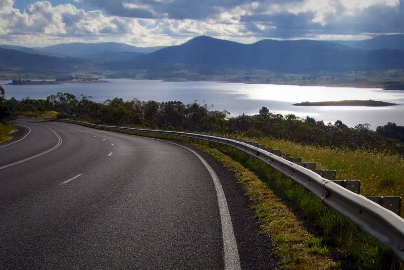
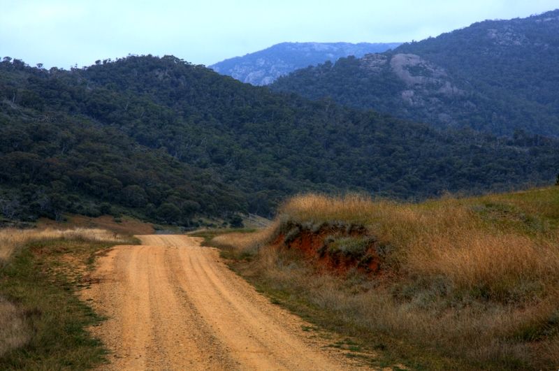
I do not know how long it would take to ride (because I'm a wanderer when I ride, I stop every 5 minutes to take shots) but I do know the road. It is a good road. Leaving Jindabyne there are a couple of big hills (photo below), it is very undulating in parts but the run into Adaminaby is brilliant, a gentle downhill, straight and with good shoulders once you're back on the Snowy Mountains Highway. Middlingbank Road doesn't have shoulders. In Adaminaby the camping store is in the Spar Supermarket. If you use ISO-Butane/Propane they have the canisters for both Kovea style and the Prinus types. If you want to ring ahead to check on the supplies, Steve Brayshaw 6454 1144.
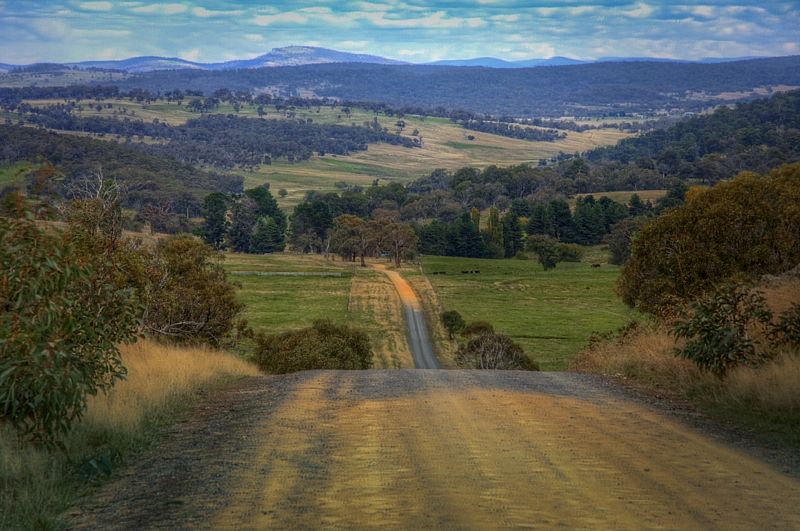
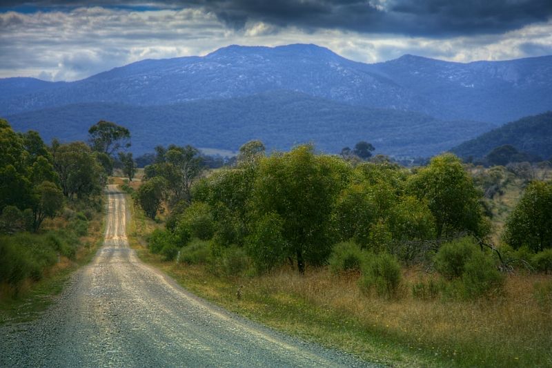
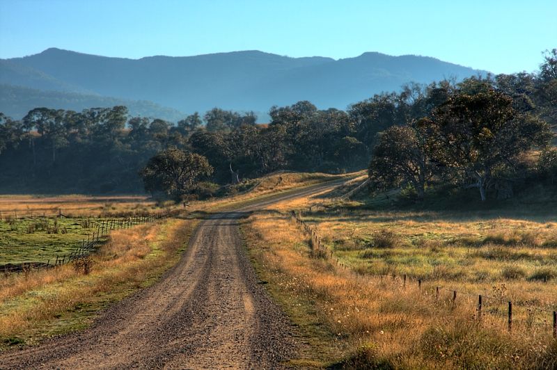
Here are some road shots from last Autumn facing in the opposite direction (mostly) to the way you could travel. The shots are in order starting 12k north of Adaminaby. I also posted the Shannon's Flat Road on your other thread.
Descending Big Bear Mountain.
Descending Little Bear Mountain.
Leaving the Murrumbidgee River at Yaouk heading towards the Kennedy's Road junction. A bit steep looking but only a 2 minute climb.
The Yaouk Bill Range at Nalyapa.
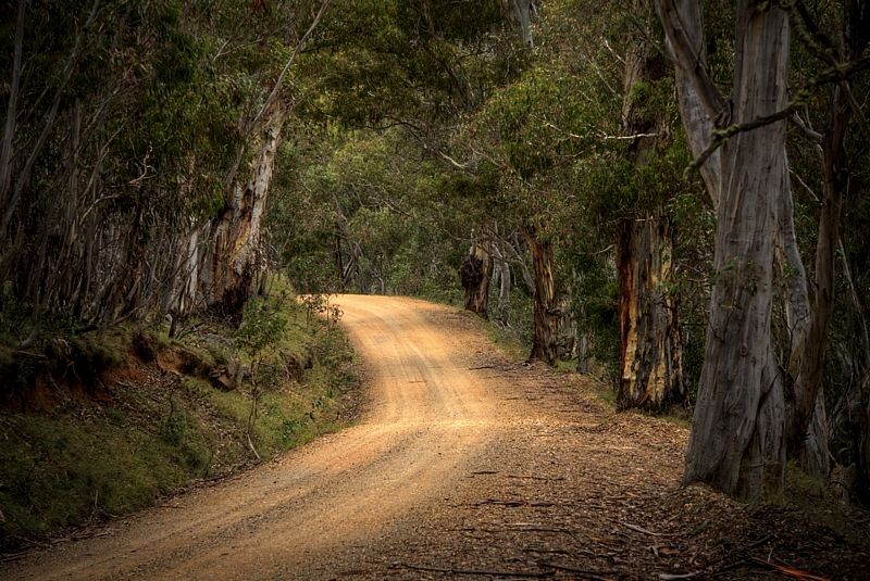
A typical shot of the Boboyan Road north of the ACT Border and typical of Yaouk Road through the forests.
Going from Adaminaby to Tharwa taking the Yaouk Road then the Boboyan Road, after Adaminaby (apart from making a farm gate request for water), it is 22 kilometres to the Murrumbidgee River.
The best resupplying is at Yaouk on the Murrumbidgee River, at Grassy Creek 200m over ACT Border, at Sheepstation Creek an upper reach of the Naas River, at Brayshaw's Hut which you will see from the road there is a new rainwater tank behind the hut. There is a rain water tank at Orroral Valley Campsite (if you are staying there it's $6 per night), at the Ranger's Station in Namadgi National Park (near Mount Tennent) and at Tharwa of course. There are several other creeks that you'll cross like Bradley's Creek and the Gudgenby River but even in an emergency you need to boil the water because of cattle.
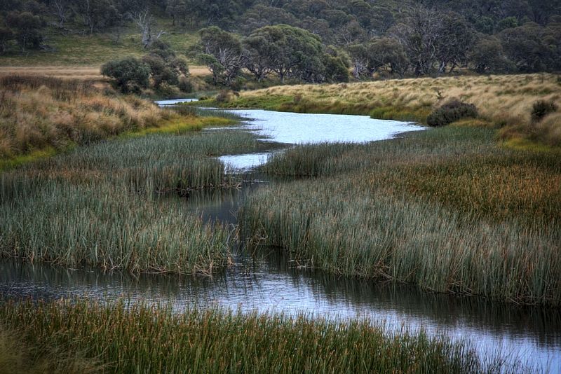
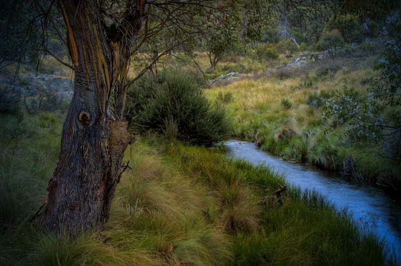
The Murrumbidgee at Yaouk has clear water.
Grassy Creek, is very grassy, but has excellently clear water. Be careful of Tiger Snakes near all the creeks, they love the grassy banks to hide.
Sheepstation Creek again has clear water.
All the huts in this region have new rain water tanks and the reliable rain has been the best I've known for the district. The farm dams are also full. If you filter and boil water there is water everywhere. If you only chemically treat the water, rely on the streams that I mentioned and Brayshaw's tank on this route until the Ranger's Station.
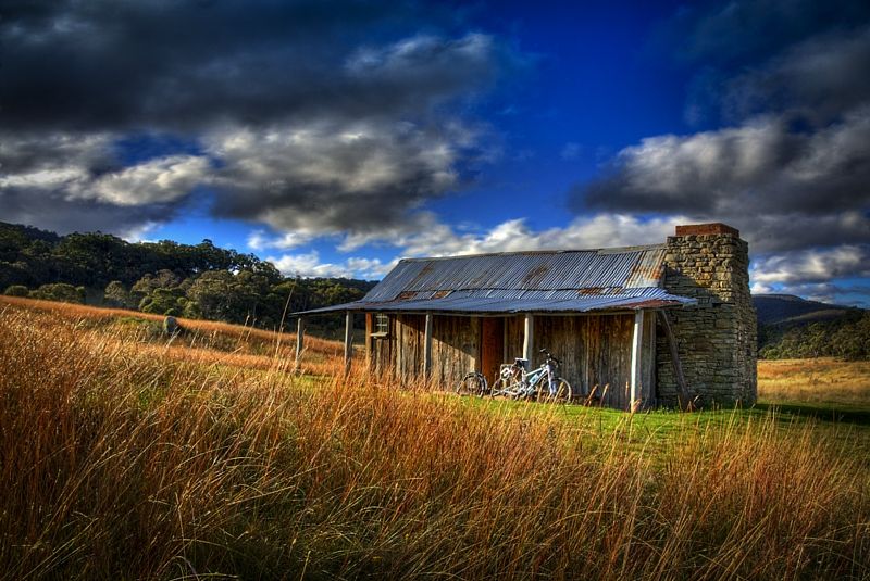
Brayshaw's Hut.
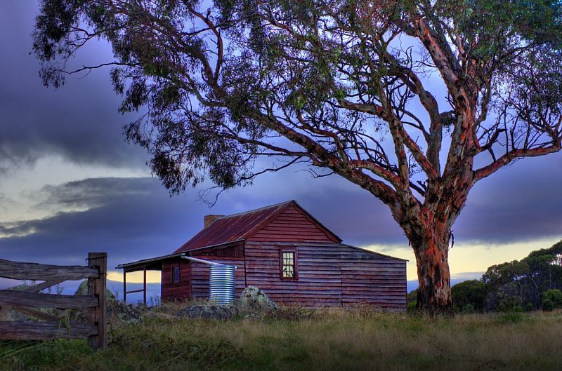
Westerman's Hut. Westerman's is about a 1.5ks west off Boboyan Road at the ACT border. The huts are great sanctuaries if the weather goes peas shaped.
If you are not familiar with Hydatid Disease ... http://ideas.health.vic.gov.au/bluebook/hydatid.asp
Warren.
PS, these photos do not steal the thunder, under any circumstances.
Jindabyne Road - Middlingbank Road - Snowy Mountains Highway ? ... 84 kilometres.What is a feasible time to go from Jindabyne to Adaminaby
I do not know how long it would take to ride (because I'm a wanderer when I ride, I stop every 5 minutes to take shots) but I do know the road. It is a good road. Leaving Jindabyne there are a couple of big hills (photo below), it is very undulating in parts but the run into Adaminaby is brilliant, a gentle downhill, straight and with good shoulders once you're back on the Snowy Mountains Highway. Middlingbank Road doesn't have shoulders. In Adaminaby the camping store is in the Spar Supermarket. If you use ISO-Butane/Propane they have the canisters for both Kovea style and the Prinus types. If you want to ring ahead to check on the supplies, Steve Brayshaw 6454 1144.
From Adaminaby via Yaouk.your suggestions to Shannons Flat and up to Tharwa then on to Canberra.
Cooma-Michelago-Canberra taking the Monaro Highway certainly is the no fun at all option. The highway is good quality road with a good shoulder ... but a better and more interesting cycling option is putting your bike in the cargo bay and catching the Murray's bus to Canberra.I had given myself initially 3 days riding from Jindabyne to Cooma, Michelago and Canberra. This route however seemed quite uninspiring, given that I would have come through Victorian railtrails, and the Alpine way through Khancoban, Thredbo.
It is a good suggestion going via Yaouk. What you will see of the northern Alps, the long valleys and generally fast riding on long downhills will blow you away. You will go over Big Bear and Little Bear Mountains, Yaouk Bill Saddle and Shanahan's Mountain and Fitz's Hill. As you reach the tarmac south of Tharwa at times there is no shoulder to rely on and seriously eroded deep gutters beside the road in a few short sections. All of this way you will enjoy the (very) light road traffic ... the heaviest traffic your likely to see from Adaminaby until Tharwa will be pedestrian traffic of cows walking up the road, especially around Yaouk and Kennedy's Road.I would be quite keen to try your suggestions.
Here are some road shots from last Autumn facing in the opposite direction (mostly) to the way you could travel. The shots are in order starting 12k north of Adaminaby. I also posted the Shannon's Flat Road on your other thread.
Descending Big Bear Mountain.
Descending Little Bear Mountain.
Leaving the Murrumbidgee River at Yaouk heading towards the Kennedy's Road junction. A bit steep looking but only a 2 minute climb.
The Yaouk Bill Range at Nalyapa.
A typical shot of the Boboyan Road north of the ACT Border and typical of Yaouk Road through the forests.
You can cut down on carrying lots of water because of good regular water on the route. Boil for 8 minutes (minimum) or use chemicals to purify what you need. Certainly do not drink straight out of the streams, no matter how clean the water looks here. This is Hydatids country.What should I look out for if I take your route. I am travelling light enough, so can take plenty of food and water with me.
Going from Adaminaby to Tharwa taking the Yaouk Road then the Boboyan Road, after Adaminaby (apart from making a farm gate request for water), it is 22 kilometres to the Murrumbidgee River.
The best resupplying is at Yaouk on the Murrumbidgee River, at Grassy Creek 200m over ACT Border, at Sheepstation Creek an upper reach of the Naas River, at Brayshaw's Hut which you will see from the road there is a new rainwater tank behind the hut. There is a rain water tank at Orroral Valley Campsite (if you are staying there it's $6 per night), at the Ranger's Station in Namadgi National Park (near Mount Tennent) and at Tharwa of course. There are several other creeks that you'll cross like Bradley's Creek and the Gudgenby River but even in an emergency you need to boil the water because of cattle.
The Murrumbidgee at Yaouk has clear water.
Grassy Creek, is very grassy, but has excellently clear water. Be careful of Tiger Snakes near all the creeks, they love the grassy banks to hide.
Sheepstation Creek again has clear water.
All the huts in this region have new rain water tanks and the reliable rain has been the best I've known for the district. The farm dams are also full. If you filter and boil water there is water everywhere. If you only chemically treat the water, rely on the streams that I mentioned and Brayshaw's tank on this route until the Ranger's Station.
Brayshaw's Hut.
Westerman's Hut. Westerman's is about a 1.5ks west off Boboyan Road at the ACT border. The huts are great sanctuaries if the weather goes peas shaped.
If you are not familiar with Hydatid Disease ... http://ideas.health.vic.gov.au/bluebook/hydatid.asp
Warren.
PS, these photos do not steal the thunder, under any circumstances.
"But on steep descending...Larson TT have bad effect on the mind of a rider" - MadRider from Suji, Korea 2001.
"Paved roads ... another fine example of wasteful government spending." - a bumper sticker.
"Paved roads ... another fine example of wasteful government spending." - a bumper sticker.
-
GregLR
- Posts: 104
- Joined: Fri Feb 18, 2011 12:43 am
- Location: Shellharbour
Re: Cycling on Shannons Flat and Bobeyan roads to Canberra
What a great set of photos to go with your comprehensive route information, WarrenH.
I've cycletoured that way as well - twice in both directions (incl via Yaouk on a southward journey). Below are links to two elevation profiles from a weekend ride with a group of friends in June 2004 to Adaminably & back from Tuggeranong Town Centre (about 20km south of Canberra city centre).
The elevation profiles don't show the exact route WarrenH suggested, since the southward one through Yaouk to Adaminably first goes via the Yankee Hat carpark & the Old Boboyan Rd (which has no traffic because of locked gates) and then takes a shortcut via the Scabby Range track through a section of national park to reach the Yaouk valley and on to Adaminaby (so the section of the profile after Yaouk Rd is relevant). The return route to Tuggeranong went directly from Adaminaby to Shannon's Flat then back via the (new) Boboyan Rd (so the Shannons Flat to Tuggeranong section of the profile is relevant).
Two of us were on road touring bikes, the rest on MTBs. Road touring bikes were very suitable on all roads except the rough Scabby Range track, which fortunately was mostly downhill going south so momentum carried us over the rough parts before joining Yaouk Rd.
I've also ridden the relatively hilly section from Jindabyne to Adaminaby via Berridale & Middlingbank several times. A very nice ride, with quiet roads after the turnoff from Berridale.
Greg
Tuggeranong to Adaminably (via Old Boboyan Rd & Yaouk):
http://4.bp.blogspot.com/-nWu6CQE5lds/T ... +Yaouk.JPG
Adaminably to Tuggeranong (via Shannons Flat & new Boboyan Rd):
http://3.bp.blogspot.com/-E4BmkhUknpE/T ... s+Flat.JPG
-
rdvmonasterio
- Posts: 18
- Joined: Fri Sep 02, 2011 11:44 am
- Location: Sydney
- Contact:
Re: Cycling on Shannons Flat and Bobeyan roads to Canberra
Thanks Greg, and Warren. I have decided to take this route. I guess one could do Adaminaby to Tharwa in one go, although I am quite keen on camping somewhere in between. Hoping the weather is fine when I am there end of November.
Is one able to stay the night in one of the mentioned huts? Do I need permission?
thanks
Is one able to stay the night in one of the mentioned huts? Do I need permission?
thanks
-
WarrenH
- Posts: 664
- Joined: Fri May 28, 2010 3:58 am
Re: Cycling on Shannons Flat and Bobeyan roads to Canberra
Ronald, G'day. I'm still in Canberra. It is too wet to take on the red clay northwest of Canberra, possibly for another day or two yet.
If you use any of the resources at the hut, make sure that you replace them. If you use the wood make sure its replaced before you leave. These mountains are the Northern spurs of the Alps, a biosphere which creates it's own weather. The huts are survival shelters.
At the bottom of Fitzs Hill at the Gudgenby River Crossing where the Boboyan Road becomes the Naas Road, the turnoff into the Naas Valley is on your right. If you have time, it is about kilometre to the top of the rise ... its a nice view.
When you get to the Ranger's Station at Mount Tennant, you are at the northern end of the Australian Alps Walking Track. At the Rangers Station there's a free map for the AAWT walk to Honeysuckle Creek campsite. There is a lookout called Cypress Pine Lookout on Mount Tennent, that is good. Again, if you have time, leave your bike at the Ranger's Station and walk to Cypress Pine Lookout or even walk to the summit of Tennent. Because you are on the Bicentennial National Trail doing the alternate bicycle route to the Main Trail (which you might not have known and have been doing the BNT alternate cycle route since Adaminaby) travellers on the BNT can camp at the Ranger's Station by agreement between Namadgi NP and the BNT Association. If you need to camp, tell the Ranger you are on the BNT. Set up camp and then perhaps climb Mount Tennent.
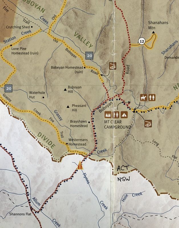
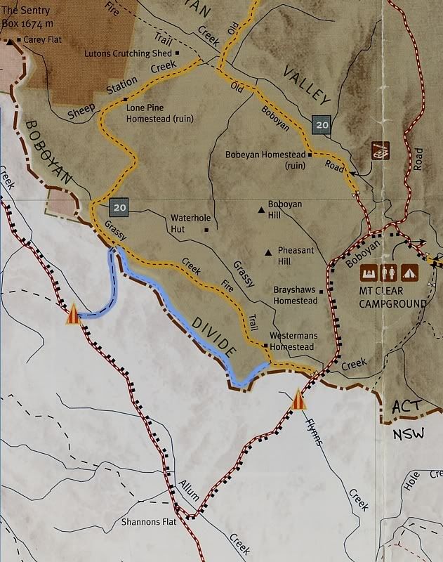
The map showing Westermans Homestead (aka Westermans No 3 Hut), Brayshaws Hut and the walking track on Shanahan's Mountain #12.
Warren.
Should a traveller ask for permission to stay in a high country hut? Ask yourself this question as you are walking through the door, "Am I in need of shelter." That is all the permission that is needed.Is one able to stay the night in one of the mentioned huts? Do I need permission?
If you use any of the resources at the hut, make sure that you replace them. If you use the wood make sure its replaced before you leave. These mountains are the Northern spurs of the Alps, a biosphere which creates it's own weather. The huts are survival shelters.
When you are going over Shanahan's Mountain, there is a walking track out to the edge of the escarpment conveniently called, 'Shanahan's Mountain Walking Track'. If you do the loop it is 3 kilometres ... dump the bike in the bush, mark its location on your GPS (if needed), then find time for the walk. This is the best short walk in the Northern Alps. This walk is easy.What should i look out for if I take your route.
At the bottom of Fitzs Hill at the Gudgenby River Crossing where the Boboyan Road becomes the Naas Road, the turnoff into the Naas Valley is on your right. If you have time, it is about kilometre to the top of the rise ... its a nice view.
When you get to the Ranger's Station at Mount Tennant, you are at the northern end of the Australian Alps Walking Track. At the Rangers Station there's a free map for the AAWT walk to Honeysuckle Creek campsite. There is a lookout called Cypress Pine Lookout on Mount Tennent, that is good. Again, if you have time, leave your bike at the Ranger's Station and walk to Cypress Pine Lookout or even walk to the summit of Tennent. Because you are on the Bicentennial National Trail doing the alternate bicycle route to the Main Trail (which you might not have known and have been doing the BNT alternate cycle route since Adaminaby) travellers on the BNT can camp at the Ranger's Station by agreement between Namadgi NP and the BNT Association. If you need to camp, tell the Ranger you are on the BNT. Set up camp and then perhaps climb Mount Tennent.
The map showing Westermans Homestead (aka Westermans No 3 Hut), Brayshaws Hut and the walking track on Shanahan's Mountain #12.
Warren.
"But on steep descending...Larson TT have bad effect on the mind of a rider" - MadRider from Suji, Korea 2001.
"Paved roads ... another fine example of wasteful government spending." - a bumper sticker.
"Paved roads ... another fine example of wasteful government spending." - a bumper sticker.
-
rdvmonasterio
- Posts: 18
- Joined: Fri Sep 02, 2011 11:44 am
- Location: Sydney
- Contact:
Re: Cycling on Shannons Flat and Bobeyan roads to Canberra
Warren,
Thank you so much for your help. I have got this route locked into my plans. I only hope the weather is kind when I go through towards the end of November.
I have enjoyed your photographs, and found your collection in deviantArt. I will do my best with my canon powershot.
Hopefully the weather will clear up soon for your trip. I keep an eye on Shaun The sheep.
-
WarrenH
- Posts: 664
- Joined: Fri May 28, 2010 3:58 am
Re: Cycling on Shannons Flat and Bobeyan roads to Canberra
Sorry, a dupe post.
Warren.
Warren.
Last edited by WarrenH on Wed Oct 26, 2011 3:27 pm, edited 1 time in total.
"But on steep descending...Larson TT have bad effect on the mind of a rider" - MadRider from Suji, Korea 2001.
"Paved roads ... another fine example of wasteful government spending." - a bumper sticker.
"Paved roads ... another fine example of wasteful government spending." - a bumper sticker.
-
WarrenH
- Posts: 664
- Joined: Fri May 28, 2010 3:58 am
Re: Cycling on Shannons Flat and Bobeyan roads to Canberra
Ronald, Shaun hey? ... he is a good friend of mine.
This is the gate at Yaouk Bill Saddle that is the turn-off to the border ... a car is trespassing, but a bike on the BNT isn't. I was on Yaouk Road when I took this shot, I've included this shot because on maps it is marked as Parklea.

The blue line is the route from Yaouk Bill Saddle and the track along the ACT/NSW Border is the new realigned Grassy Creek Track. The yellow broken lines are bike friendly and the yellow dotted lines are walking tracks only, like on Shanahans Mountain.
Good luck from both me and Shaun ... and the mob. We are looking forward to your shots and as you can see there is a bit of keen interest.
Warren.
If you want to make for Westermans No 3 Hut. This route is a relatively new route, and saves doubling back. This new track is for the BNT, particularly for pack horsing, to keep the horses off the road. If you are taking this route, there are combination locks on the gates. You can obtain the number from the Namadgi Park Ranger. This will get you through two locked gates, the first when entering the ACT and the other getting back onto Boboyan Road from the Grassy Creek Fire Trail. This saves having to lift the bike over the fence and portage of panniers. Not far from the main gates you will see the smaller gate for bikes and horses.Another option to this route, is at the property called Pacyotl, on the Yaouk Bill Saddle, go through the property gate (allowed) and follow the track uphill onto the Boboyan Divide. Then on the new Grassy Creek Fire Trail at the Namadgi National Park gate, take this trail east (the old ACT/NSW Border Track) to the Namadgi Park boundary at Boboyan Road then head north towards Tharwa. You will see Westermans No 3 Hut when you reach the grass lands. There is good water at the hut.
This is the gate at Yaouk Bill Saddle that is the turn-off to the border ... a car is trespassing, but a bike on the BNT isn't. I was on Yaouk Road when I took this shot, I've included this shot because on maps it is marked as Parklea.
The blue line is the route from Yaouk Bill Saddle and the track along the ACT/NSW Border is the new realigned Grassy Creek Track. The yellow broken lines are bike friendly and the yellow dotted lines are walking tracks only, like on Shanahans Mountain.
Good luck from both me and Shaun ... and the mob. We are looking forward to your shots and as you can see there is a bit of keen interest.
Warren.
"But on steep descending...Larson TT have bad effect on the mind of a rider" - MadRider from Suji, Korea 2001.
"Paved roads ... another fine example of wasteful government spending." - a bumper sticker.
"Paved roads ... another fine example of wasteful government spending." - a bumper sticker.
-
octagonalman
- Posts: 43
- Joined: Tue Sep 03, 2013 7:36 pm
Re: Cycling on Shannons Flat and Bobeyan roads to Canberra
Having been in the area earlier in the month, I can say that the road conditions were sufficiently poor that I was unable to really enjoy the downhills (I was more holding on for dear life!). Trying to find respite while bouncing along the top of the corrugations, all I could find was sand that my 700x35's cut straight through. The NSW side was noticeably worse. We had a chat with people in town who had encountered misfortune on Boboyan Road in their other modes of transport. One broke a leg while riding a motorcycle and another managed to get a flat tyre, in the middle of a night. The scenery is gorgeous though and the weather was overcast on the day, which was good in that there was no sun beating down. My group did have different constraints as we're not of the camping type and were pushing Canberra to Adaminaby in one day.
-
FatGuts
- Posts: 112
- Joined: Sun Dec 23, 2012 10:08 am
- Location: Punting down The Luge........
Re: Cycling on Shannons Flat and Bobeyan roads to Canberra
octagonalman wrote:Having been in the area earlier in the month, I can say that the road conditions were sufficiently poor that I was unable to really enjoy the downhills (I was more holding on for dear life!). Trying to find respite while bouncing along the top of the corrugations, all I could find was sand that my 700x35's cut straight through. The NSW side was noticeably worse. We had a chat with people in town who had encountered misfortune on Boboyan Road in their other modes of transport. One broke a leg while riding a motorcycle and another managed to get a flat tyre, in the middle of a night. The scenery is gorgeous though and the weather was overcast on the day, which was good in that there was no sun beating down. My group did have different constraints as we're not of the camping type and were pushing Canberra to Adaminaby in one day.
The Bobyan road is one that I would not recommend anyone do on a 700c wheel, MTB is the norm.
Yes its rough, sandy is unusual. It is due fr a grade though, it usually gets one before and after winter,
-
lobstermash
- Posts: 1426
- Joined: Fri Jun 07, 2013 8:51 pm
- Location: Canberra
Re: Cycling on Shannons Flat and Bobeyan roads to Canberra
And please don't do it on a weekend or public holiday. There are some serious nuts that drive it at high speed with little regard for other cars, let alone wheeled speed bumps.

-
digga67
- Posts: 7
- Joined: Fri Sep 21, 2012 12:16 pm
Re: Cycling on Shannons Flat and Bobeyan roads to Canberra
Special thanks to participants of this thread ('specially Warren's photos!). It was the inspiration for my first 'bike packing' trip last weekend. Canberra-Orroral campground-Old Boboyan Rd-Clear Mountain campground-Naas Vally-Canberra.
Was lucky with the weather but bloody cold for a Brisbanite! Pls forgive the photo overload.


Sent from my iPad using Tapatalk HD
Was lucky with the weather but bloody cold for a Brisbanite! Pls forgive the photo overload.
Sent from my iPad using Tapatalk HD
Who is online
Users browsing this forum: No registered users