
I don't know if this is the right place to post this but i think that most cycle tourers would not consider this route.
I am developing an interest in doing this route. Anyone here done any of it. Do you know any good resources.
What i'd really like to see at this stage is a decent online map of the route. I know the official website has a verbal description of the route but it would be nice to see it as a map.
I want to avoid buying their guidebooks and stuff. I'd prefer to spend my money elsewhere, so where else can i get blogs and info about the route for planning purposes.
I've done a fair bit of touring before in outback australia and overseas. The hardest part i think about this trip may be having to push my loaded bike up some sections. I"m female and not so big. I'd like help in figuring out how much weight i could manage to push up those hills. Ie how much gear should i take. I know genearlly less is best.
Also i want to find out where food supply centres are, hence the need for a decent map of the route.
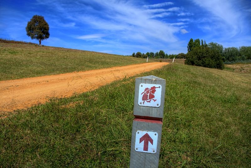
Bicentennial National Trail
-
Meditator
- Posts: 292
- Joined: Sat Feb 11, 2012 1:57 pm
- Location: North of Cairns
-
trailgumby

- Posts: 15469
- Joined: Sat Jan 03, 2009 5:30 pm
- Location: Northern Beaches, Sydney
- Contact:
Re: Bicentennial National Trail
I believe BNA'er WarrenH may be able to help you.
See thread: http://www.bicycles.net.au/forums/viewt ... &start=100
See thread: http://www.bicycles.net.au/forums/viewt ... &start=100
-
Meditator
- Posts: 292
- Joined: Sat Feb 11, 2012 1:57 pm
- Location: North of Cairns
Re: Bicentennial National Trail
Thanks trailgumby
-
WarrenH

- Posts: 664
- Joined: Fri May 28, 2010 3:58 am
Re: Bicentennial National Trail
The best resource for planing and for doing the Bicentennial National Trail is visiting the BNT Site, reading everything on the site firstly, joining the BNT Association and then talking to each of the 32 section coordinators. My name is Warren Hudson I'm a section coordinator and I'm a cyclists on the trail.Meditator wrote:I am developing an interest in doing this route. Anyone here done any of it. Do you know any good resources.
The Bicentennial National Trail is a living trail that follows the old and extant travelling stock routes, aboriginal pathways, fire trails, back tracks and quiet rural roads and rivers along the Great Dividing Range and recently included is the Brisbane Valley Rail Trail. The BNT is still, at times, part of the working life of rural Australia. On the BNT every track, road and unformed road surface possible will be encountered. Changes to the trail can happen (overnight) for various reasons; like flooding, fires, landslides, landholders making changes to access (changing combination to locks on gates on their properties) and Forestry logging coups going on-line, may require taking an alternate route, amongst the other reasons. Apart from those who have done the trail, or sections of the trail, posting their routes (which are not always accurate) on their blogs or on crazyguy', the only truly accurate trail guides are the guide books and the current alterations to the trail, that appear in the DOWNLOADS section on the BNT site. The only accurate map(s), are the guide books and keeping your eye on the changes to the track, posted on the BNT site. The guide books are also essential for gaining access to where the trail crosses private properties, they include many property owner's names and phone numbers. In the guide books the route is distanced and described in much detail.Meditator wrote:What I'd really like to see at this stage is a decent online map of the route. I'd like to get the big picture. I know the official website has a description of the route but it would be nice to see it as a map.
I don't think that you can safely do the trail without the guide books and talking to the trail coordinators about current and local conditions. The BNT travels through serious country, including untracked wilderness. Taking on the BNT is not for novices. The BNT has the hardest trail trail classification of any of the international trails on the planet, 10/10 for difficulty. It is on par only with the Iditarod Trail in Alaska, which is also rated at 10/10 for difficulty. If you ride the BNT from Cooktown to Healesville you will have climbed the equivalent of Mount Everest from sea level, 10.6X. Buying the guide books is just the start, and the least expensive component of taking on the BNT.Meditator wrote:I want to avoid buying their guidebooks and stuff. I'd prefer to spend my money elsewhere, so where else can I get blogs and info about the route for planning purposes.
Correct. If you do the entire trail from Cooktown in FNQ to Healesville in Victoria following the Main Trail (that will be 3,530 km of trail with several dozen serious river crossings, including some crossing with crocodiles) or then add another 600-800 kilometres more riding, if you follow several possible alternate BNT cycling routes to avoid the rivers and extreme sections. The climbing on the trail if ridden over 5 months, is between 700-800 metres of climbing per day ... and the downs can be harder and less rideable than the ups.Meditator wrote: The hardest part I think about this trip may be having to push my loaded bike up some sections. I'm female and not so big. I'd like help in figuring out how much weight I could manage to push up those hills. Like how much gear should I take. I know generally less is best.
This is a self reliant trail. Although there are 32 towns on or close to the trail, not all towns are suitable for resupplying. Some are tourist towns only and are basically only open on weekends. Also in Northern NSW, unless you leave the trail for resupplying in a main regional town, you could be riding for 30 days without the chance of adequate resupplying. One option is to post your supplies ahead to guest houses or to the section coordinators that are on or near the trail.Meditator wrote:Also I want to find out where food supply centres are, hence the need for a decent map of the route.
Yes I do, I'm set up for up to 8 weeks travelling without the need for resupplying, in any aspect. How do I carry it up the rough bits? Portage. How much of the trail have I done? Most of the BNT Main Trail in NSW and all of the ACT and many of the alternate BNT cycling routes in both NSW and the ACT. Some sections (particularly Guide Book 10) I've done several times in both directions. I have done none of the current BNT in Qld, and in Victoria not much at all. I've also done sections of the original BNT, when it was called the National Horse Trail. I'm mentioning this because Google Maps is showing parts of the old decommissioned National Horse Trail the Bicentennial National Trail. I sometimes get mail saying that the BNT is confusing or wrong ... it isn't too confusing or wrong in the guide books with the current updates copied from the BNT site and then glued into the guide books.Meditator wrote:I see you've got a bit of gear on your bike. How did you go carrying it up some rough bits. Did you have to do that? How often? In fact how much of the trail have you done?
You are very welcome. I like talking on the phone 02 62540295 or leave me a message, and I'll ring you back ... rather than answering emails. There are a lot of fine details like how to organize permits and why might need them, things that are easier to talk about than to awkwardly write about. I get up to 20 emails a week some weeks about the BNT, and currently I'm getting about 4 or 5 a day. It must be approaching the autumn touring season? If you are unsure about what is realistic to do and would like to have a chat, I'm sure we could work out what sections are realistic to undertake.Meditator wrote:Sorry for so many questions. Just answer what you want. The more the better for me of course.
Thank you ... here are a few more from me, if you like pics of off-roading on the Great Divide? ... http://s225.photobucket.com/albums/dd301/WildWassa/Meditator wrote:Your pictures are certainly enticing.
There are some good cycling trip reports that might inspire you to take on the trail.
Michael Johnson's 'The Big Nasty Track' from Healesville to Canberra, with several excellent short videos showing river crossings and huts ... http://www.crazyguyonabike.com/doc/?...c_id=8146&v=sa
http://www.youtube.com/user/Michaelr...25/YMxb7NVim1A
Andy Friend's 'The Friendly Ride' a supported ride from Cooktown to Canberra, first class commitment ... http://www.andyfriend.com.au/
Robert Klei from Canada ... of 'Rob and Bob' fame, who rode the entire trail length one and a half times, incorporating the alternate BNT cycle routes to avoid the major river crossings ... http://www3.telus.net/public/robgwen/BNT/BNT_Index.html
An excellent blog in two parts from Craig Amour aka Spoonie who rode the BNT from Canberra to Capertee before branching off into the Watagans ... http://spoonboy.solonutter.org/blog/?p=365
Some questions that I fielded in the Touring Section ... http://www.bicycles.net.au/forums/viewt ... =2&t=31546 ... and also search BNT here, I've contributed to a few BNT threads.
My favourite BNT section and the favourite section of many riders, is the BNT through the Northern Blue Mountains, along Myrtle Creek below the Yodellers Range and approaching the Widden Valley from Bell's Gap. Photos courtesy of David Noble ... http://www.david-noble.net/BlueMts/Widden/Widden1.html
Fair tail winds.
Warren.
Last edited by WarrenH on Tue Feb 14, 2012 1:07 pm, edited 5 times in total.
"But on steep descending...Larson TT have bad effect on the mind of a rider" - MadRider from Suji, Korea 2001.
"Paved roads ... another fine example of wasteful government spending." - a bumper sticker.
"Paved roads ... another fine example of wasteful government spending." - a bumper sticker.
-
Meditator
- Posts: 292
- Joined: Sat Feb 11, 2012 1:57 pm
- Location: North of Cairns
Re: Bicentennial National Trail
Thanks for the detailed reply.
I really can't afford to buy all those books. I shall have to fish about for alternatives. And do a refresher course in orienteering.
Yes thanks i did find a few blogs today. I'll study more closely when i go out and buy a map of the east coast on Wednesday.
The sound of posting food parcels sounds sensible. There have been times in the past when i toyed with the idea and regretted not doing it. So i do know what you mean by those shops who don't stock what you need.
Since i'm from northern Australia, i'm thinking of starting the trip from the south.
In the section where they say that one shouldn't do this alone, what exactly is the danger that they refer to in the cyclist notes. I think its in the first section after Healesville, or is it around Kosziosko. I thought perhaps if this stretch was too hard for a bike, it might not be a bad idea to hike it and then pick up the bike at the next section. Would that be a good idea, do you think?
I'll phone you when i want to refine my ideas more and after reading whatever else i can find.
Why is the trail managed the way it is and not by various government authorities? (i'm not sure they would do it better but it might be cheaper).
-
WarrenH
- Posts: 664
- Joined: Fri May 28, 2010 3:58 am
Re: Bicentennial National Trail
I can fully appreciate that. You could always get a guide book for a section that you would like to do, then link together some of the alternate cycle routes that are mentioned on the BNT site to extend the ride. In northern NSW the alternate cycle routes are for the intrepid.Meditator wrote:I really can't afford to buy all those books. I shall have to fish about for alternatives.
Meditator wrote:In the section where they say that one shouldn't do this alone, what exactly is the danger that they refer to in the cyclist notes.
The BNT goes through some of the remotest parts of the Great Dividing Range and a traveller can be a long way from help even if one fires off a personal locator beacon. The river crossings for solo travellers are the issue. Some rivers can be knee deep in the morning and metres deep and life threateningly rapid within hours, even when there are no sign of rain in the region and of course when the weather goes pear-shaped in the mountains. Alpine weather can be extreme and treacherous.
I always travel alone, I like the sollitude. I don't carry a locator beacon like a Spot, that is my preference but I do have a Next G phone with a high gain antenna.
Victoria is the hardest section for bike riders, unquestionably. If you can ride any part of Victoria, you can ride all of it. Even the strongest riders walk often in Victoria. If you can organise the transportation for both you and your bike, that is a great idea.Meditator wrote: I think its in the first section after Healesville, or is it around Kosziosko. I thought perhaps if this stretch was too hard for a bike, it might not be a bad idea to hike it and then pick up the bike at the next section. Would that be a good idea, do you think?
The trail from Tom Groggin or from Khancoban both on the Victorian Border, north to Rydal in the Southern Blue Mountains is the easiest section of the entire trail. It has several good towns for resupplying including Canberra. There are fantastic side trips, to places like Mount Jagungal, the Yarrangobilly thermal springs, Blue Waterholes and Caves Creek. Many high country huts and wild campsites are right on the trail. The fishing spots are some of the best going in the SE. There are too many extraordinary views to appreciate in this section. Approaching the southern ACT and in the southern ACT you'll be blown away with the rugged beauty of the place. You will possibly choose to hike the bike here, just to go slowly. North of Canberra, the rural riding to the Southern Blue Mountains is very peaceful and riding along the Lake George Escarpment then through Lerida and Cullarin is stunning. Here you can camp in the Travelling Stock Reserves. There are many bike stores in Canberra, if you need a tune up or spares. When you pass Mount Werong, a side trip to Kanangra Walls is a must do or even ride out to the ghost town of Yerranderie on the Historic Oberon Stock Route and check out the Blue Breaks and the old silver miner's slab cottages. You can descend to Jenolan Caves then head back to civilization on the Cox River Road. If you continue to Rydel from Mount Werong, the BNT goes right past the railway station. Like all the sections, this section has its moments.
Assistance is given at times by various government agencies to the BNT Association but the trail is funded by the BNT Association memberships and the sale of guide book. If the BNT was run by government agencies do you think that the revolving door of public servants, would know the trail and answer your questions, as well as those who actually do it, which you have mentioned. One thing that you will not be able to get off the web when you do get the maps off some of the blogs, are the access phone numbers. Without the phone numbers for access, the maps can result in dead ends ... requiring an equal effort for backtracking and unfortunately the use of one's valuable resources. You get what you pay for on the BNT.Meditator wrote:Why is the trail managed the way it is and not by various government authorities? (i'm not sure they would do it better but it might be cheaper).
Warren.
Last edited by WarrenH on Tue Feb 14, 2012 12:52 pm, edited 1 time in total.
"But on steep descending...Larson TT have bad effect on the mind of a rider" - MadRider from Suji, Korea 2001.
"Paved roads ... another fine example of wasteful government spending." - a bumper sticker.
"Paved roads ... another fine example of wasteful government spending." - a bumper sticker.
-
silentbutdeadly

- Posts: 2294
- Joined: Fri Apr 09, 2010 9:52 am
- Location: Somewhere flat...
Re: Bicentennial National Trail
Not a snowball's chance in Hell...and if they did it would cost track users a bomb in trail fees and it would still lead to glorious mediocrity and disappointment.WarrenH wrote:If the BNT was run by government agencies do you think that the revolving door of public servants, would know the trail and answer your questions, as well as those who actually do it, which you have mentioned.
This is one of those wonderful times when community taking ownership and responsibility is the key to maintaining a community resource. If you want to make best advantage of the BNT then support the organisation that supports the Trail...without them there will be no Trail.
Ours is not to reason why...merely to point and giggle
-
L'iota
- Posts: 118
- Joined: Wed Feb 11, 2009 10:43 am
- Location: Central Coast, NSW
Re: Bicentennial National Trail
G'day Meditator,
I have cycled with a supported group of 4 from Nowendoc to Nullo Mtn on a 6 day trip and several 1 day trips on other parts of the BNT in NSW. I also have done a 4WD reconnaissance of most of the BNT in NSW from the Qld border to Kancoban in preparation for future trips. I have a spreadsheet with fine detail of campsites, shops etc which may be of help to you.
Regardless of the cost (it goes to a good cause) The BNT Guidebook relevant to the particular section on which you are travelling is a MUST have. The more recent editions have much better maps.
The BNT is a great and varied ride with some long sections without major climbs.
L'iota
-
Meditator
- Posts: 292
- Joined: Sat Feb 11, 2012 1:57 pm
- Location: North of Cairns
Re: Bicentennial National Trail
Have you ever considered combining all the most essential info into one book? If not why not?
I don't understand the need for so many books. Its only 4000km after all. Maybe a dedicated book for cyclists would be a good idea. Maybe i will write one. I can't imagine the fact of changing trails is such a big deal .
I also had the idea of using a metal marker tag wired to a tree with a bit of steel cable and that can be easily moved when the trail changes, rather than a post stuck in the ground.
Or is it that the idea of all the books is to keep numbers on the trail low?
-
WarrenH
- Posts: 664
- Joined: Fri May 28, 2010 3:58 am
Re: Bicentennial National Trail
Meditator wrote:Have you ever considered combining all the most essential info into one book? If not why not?
I don't understand the need for so many books. Its only 4000km after all. Maybe a dedicated book for cyclists would be a good idea. Maybe i will write one. I can't imagine the fact of changing trails is such a big deal .
I also had the idea of using a metal marker tag wired to a tree with a bit of steel cable and that can be easily moved when the trail changes, rather than a post stuck in the ground.
Or is it that the idea of all the books is to keep numbers on the trail low?
"But on steep descending...Larson TT have bad effect on the mind of a rider" - MadRider from Suji, Korea 2001.
"Paved roads ... another fine example of wasteful government spending." - a bumper sticker.
"Paved roads ... another fine example of wasteful government spending." - a bumper sticker.
-
WarrenH
- Posts: 664
- Joined: Fri May 28, 2010 3:58 am
Re: Bicentennial National Trail
All of the essential information is in the 12 books. The books have both the North to South and the South to North routes. Being a multi-use trail the information is important to all the modes of travelling. The books are just the right size to fit in the window of your bar bag, when opened showing the track notes on the left and map on the right. When you finish a book, you can post it home to reduce the weight. One book would be far too heavy to carry all the way.Meditator wrote:Have you ever considered combining all the most essential info into one book? If not why not?
If you acquire one book, you soon will. The Main Trail is 5330 kilometres long and depending on the alternate cycle routes that a rider could choose, to avoid the difficult or slow bits of the Main Trail, add 600-700 or even 800 kilometres further to the length of the trail.Meditator wrote:I don't understand the need for so many books. Its only 4000km after all.
Meditator wrote:Maybe a dedicated book for cyclists would be a good idea. Maybe I will write one.
There are notes to cyclists on the BNT site. If you are considering writing a book, could I suggest that you buy all 12 guide books, then ride the Main Trail and also ride the alternate cycle routes ... just to know where to start, so that you will know what isn't essential, then know what to leave out.
It probably isn't if there are trails to change onto when the going get tuff and you have detailed maps and a compass to aid in bailing-out. I can appreciate that it is difficult to understand what the trail is like from sitting back and trying to visualise what it can be like when you are doing the research ... it is far harder on the trail.Meditator wrote:I can't imagine the fact of changing trails is such a big deal.
Not all blazes are on posts stuck in the ground. Some blazes from time to time have been stolen ... then one certainly needs a guide book. Although the trail is continuously marked/blazed you can be looking at a day between blazes or even further apart. This is not a trail like some found in North America where standing at the blaze the next blaze can be seen.Meditator wrote:I also had the idea of using a metal marker tag wired to a tree with a bit of steel cable and that can be easily moved when the trail changes, rather than a post stuck in the ground.
The new guide books increase the numbers of travellers on the trail. The trail is for the intrepid amongst us. Many come, many try and many leave. Cyclists now are the majority of travellers using the BNT but they are also the greatest number of travellers on the trail that bail-out. There are also new guide books dedicated to sections of the trail that can be looped, so that travellers can experience a pleasant Weekend on the Trail.Meditator wrote:Or is it that the idea of all the books is to keep numbers on the trail low?
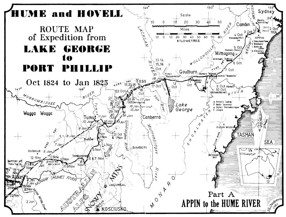
Have you considered the Hume and Hovell Track and the alternate cycle routes for the Hume and Hovell Walking Track? ... the 6 map kit is only $30 with all the details. The Hume and Hovell is about 400 kilometres long and is dedicated to Hamilton Hume and William Hovell's 1824-25 expedition from Lake George to Port Phillip and like the BNT the H&HWT it has its moments. The Hume and Hovell Track is from Yass at Cooma Cottage to the Hovell Tree in Albury, about a quarter of the distance that Hume and Hovell did.
In the words of the infamous cycling explorer Melvyn Yap ... "Suspicious looking individuals please go this way."
The photo of a blaze on the HHWT is by me, Melvyn can't be blamed for it.
Warren.
Last edited by WarrenH on Thu Feb 23, 2012 8:21 pm, edited 1 time in total.
"But on steep descending...Larson TT have bad effect on the mind of a rider" - MadRider from Suji, Korea 2001.
"Paved roads ... another fine example of wasteful government spending." - a bumper sticker.
"Paved roads ... another fine example of wasteful government spending." - a bumper sticker.
-
Meditator
- Posts: 292
- Joined: Sat Feb 11, 2012 1:57 pm
- Location: North of Cairns
Re: Bicentennial National Trail
Under no circumstances would i or could I imagine carrying 12 books. That would only make sense to someone with a pack horse. Sending each home after use is just more expense so taht buy the time i got home, i might have spent $1000 on a guidebooks which really is just too rediculous. Id rather allocate the weight to food and the money to better quality gear. I'll buy a compass, do a refresher orienteering course, talk to the locals and attempt the whole trail. If i choose to opt for a side road instead of the trail, i can easily choose myself what way to go by looking at the maps and talking to locals.
I've plotted the whole route using the cyclist notes on a map of the east coast and it looks doable. In doing this, i can see a myriad of options to take if the trail is too rough or if i can't find it.
I'll be able to find the names and contact details of the landholders myself. I am sure that not be difficult.
-
WarrenH
- Posts: 664
- Joined: Fri May 28, 2010 3:58 am
Re: Bicentennial National Trail
That's why I mentioned earlier, about posting ahead. If you are attempting to do the trail end-to-end, you have to plan it like a military campaign taking into account the logistics.Meditator wrote:... I imagine carrying 12 books. That would only make sense to someone with a pack horse.
Meditator wrote:I might have spent $1000 on a guidebooks which really is just too rediculous.
It certainly is just too ridiculous to spend a $1000 on the guide books, when you can purchase all 12 of them from the BNT Association with BNT Association Membership for $390.
That will cost you far more than buying the books.Meditator wrote:I'll buy a compass, do a refresher orienteering course, talk to the locals and attempt the whole trail. If I choose to opt for a side road instead of the trail, I can easily choose myself what way to go by looking at the maps and talking to locals.
That is a good idea. If you don't want to do the big river crossings, carry your bike for weeks through several tracts of untracked wilderness and not be too far from good towns for resupplying, that would work.Meditator wrote:I've plotted the whole route using the cyclist notes on a map of the east coast and it looks doable. In doing this, I can see a myriad of options to take if the trail is too rough or if i can't find it.
Can I give you a little quiz to show you how difficult that is to do ... remembering that I'm a thousand kilometres from where blackfelt is writing about ... http://www.bicycles.net.au/forums/viewt ... f=2&t=8401Meditator wrote:I'll be able to find the names and contact details of the landholders myself. I am sure that not be difficult.
Concerning the last and second last posts on the thread, can you find the names of the 4 property owners involved, that were needed to give blackfelt access? blackfelt got turned away at the first hurdle, he need all four property owner's permission to continue and he was talking to the first property owner.
How long do you think it will take me to find those four phone numbers in the guide book?
Say you have to turn around and ride back over 100+ kilometres because you missed out on one phone number ... if the trail is important to anyone to do well, safely and efficiently, penny pinching just isn't worth being caught out over, by missing a turnoff, by not having a guide book ... for the sake of a horse a kingdom was lost. It is all relative.
Warren.
"But on steep descending...Larson TT have bad effect on the mind of a rider" - MadRider from Suji, Korea 2001.
"Paved roads ... another fine example of wasteful government spending." - a bumper sticker.
"Paved roads ... another fine example of wasteful government spending." - a bumper sticker.
-
rokwiz

- Posts: 270
- Joined: Sat Jan 14, 2012 4:14 pm
- Location: Eastcoast Australia
- Contact:
Re: Bicentennial National Trail
Hi guys,
Sorry but Hume and Hovell started their expedition from Fish River 6 miles north of Gunning. NSW (17th October 1824.)There's a bloody great monument there on the side of the Old Hume Hwy, between the properties Collingwood and Wodonga. Geoff
Sorry but Hume and Hovell started their expedition from Fish River 6 miles north of Gunning. NSW (17th October 1824.)There's a bloody great monument there on the side of the Old Hume Hwy, between the properties Collingwood and Wodonga. Geoff
In order that the labour of centuries past may not be in vain during the centuries to come... D Diderot 1752
-
WarrenH
- Posts: 664
- Joined: Fri May 28, 2010 3:58 am
Re: Bicentennial National Trail
Have you read Hume and Hovell 1824 Edited by Alan E J Andrews. ISBN 0 908528 07 8 Hume and Hovell 1824, contains Hume's Report of the Expedition 1825. Hovell's Journal 1824, Dr Blands Account 1831. Maps, extracts and satements of facts, various speeches and letters between Hume and Hovell.
The route map of the expedition is from Lake George to Port Phillip. I'm not one to question the map first drawn by Hamilton Hume. I do know that they went to Hume's Father's property Wooloobidallah on the Fish River, a branch of the Lachlan River. The Expedition actually started on Saturday 2nd of October 1824 from Appin in the County of Cumberland.
This map might help ... http://www.sl.nsw.gov.au/discover_colle ... /maps.html
This map might help even more.
Warren.
Last edited by WarrenH on Thu Feb 23, 2012 7:15 pm, edited 1 time in total.
"But on steep descending...Larson TT have bad effect on the mind of a rider" - MadRider from Suji, Korea 2001.
"Paved roads ... another fine example of wasteful government spending." - a bumper sticker.
"Paved roads ... another fine example of wasteful government spending." - a bumper sticker.
-
rokwiz
- Posts: 270
- Joined: Sat Jan 14, 2012 4:14 pm
- Location: Eastcoast Australia
- Contact:
Re: Bicentennial National Trail
Yes, I have read the book and researched this thoroughly in Gunning library on local history, the monument which I've partly worked on (as a Heritage Stonemason) under a Fed Gov grant, yeh read what in the local library records, I will be carving a new marble plaque (damaged)( when they cough up the doe) which replaces the wording the "expedition started here 17th October 1824." Monument was placed there 1924 to mark 100 years
Geoff

Geoff
In order that the labour of centuries past may not be in vain during the centuries to come... D Diderot 1752
-
Meditator
- Posts: 292
- Joined: Sat Feb 11, 2012 1:57 pm
- Location: North of Cairns
Re: Bicentennial National Trail
FROM THE LINK THAT WARRNE GAVE ABOVE. BLACKFELT
Blackfelt was on a trail bike. Hardly surprising that he got turned off the property really. Are you suggesting that this will happen to me.Hi guys, my first posting and I must say ive found a wealth of info on here cheers.
More info on riding from Drake NSW to long gully road/ Rocky river road, Upper Rocky river road. I got as far as the southern side of Moogem on a DR650 then a farmer (where you cross over the deeper river twice) quite politly told me to get off his land which was fair enough I suppose. Awesome country, many gates, in fact if your going through heaps of gates and small paddocks and see a newish shed turn back locked gates from there on , go as a group = good saves arguing with yourself. From the bruxner hwy head south 31 klicks and there should be a NP gate on the left heading east (locked of course but looked used?). This road leads to other forest trails in Ballilimbra state forest on google maps any way and lead all the way to the Gwydir. If the gate wasnt locked I would of been up there like a rabbit. Ill get fit again and go for another mission when its cooler.
Just riding down the Long Gully road is awesome, quite steep at the start. Road is hard pack with white quartz marbles, very slippery on a motorbike
Oh and stop on the concrete course way its beautiful, stunning. There is a gate telling you "no through road" its just after that.
Im planning on a cycle/hike through there when im fitter and the weather is cooler and I know I can get through.
Thanks
blackfelt
WARREN
by WarrenH » Thu Feb 09, 2012 4:15 am
QUOTE: blackfelt wrote:
More info on riding from Drake NSW to long gully road/ Rocky river road, Upper Rocky river road. I got as far as the southern side of Moogem on a DR650 then a farmer (where you cross over the deeper river twice) quite politly told me to get off his land which was fair enough I suppose.
The deep river is the Timbarra River.
As you know, the road gradually deteriorates as you head up the valley, but is in very cool and stunningly beautiful country. You were travelling through private properties here, which you soon found out, hey? It didn't help being on a DR650. The farmers here don't mind if you are on a horse, on foot or a push-bike, you can travel through their properties. The last property ends where the track enters Washpool National Park, at Swamp Creek.
At Washpool at Dry Creek, you have to carry the bike, if you are up for it (about 4 kilometres). This is extremely beautiful country but the river bed is the only route here and is too rocky to ride ... until you leave the creek and rejoin the track about 6 kilometres north of North West Fire Trail.
In future for access, if you do a return trip you can ring the landholders. You'll find their phone numbers in the Bicentennial National Trail Guide Book #7, Killarney to Ebor. GB#7 can be obtained from the BNT Association's web site.
You are able to camp on the private properties, at Newsom's Hut and at Jack's Hut, but again, you have to ring ahead of time.
Warren.
Jump to:
-
Meditator
- Posts: 292
- Joined: Sat Feb 11, 2012 1:57 pm
- Location: North of Cairns
Re: Bicentennial National Trail
WARRNE Can I give you a little quiz to show you how difficult that is to do ... remembering that I'm a thousand kilometres from where blackfelt is writing about ... http://www.bicycles.net.au/forums/viewt ... f=2&t=8401WarrenH wrote:WARREN That's why I mentioned earlier, about posting ahead. If you are attempting to do the trail end-to-end, you have to plan it like a military campaign taking into account the logistics.Meditator wrote:...ME I imagine carrying 12 books. That would only make sense to someone with a pack horse.
ME I'll post food but i am not going to send parcels with a book in each. that would cost at least $10 each. Ok so the cost of 12 is only $390 I read somewhere they were $50 each. So the total now is $610 and then i post them them home one at a time. There's another $120 = $730. Hardly a bargain. Not even a bargain at $390. Perhaps you could consider selling them to libraries around the country so that users have can have more affordable access. It can be suggested that they keep them in the reference section so that people can't take them away and bugger up the series by losing them or stealing htem or whatever. Even i'd go and sit in a library to take notes. In addition, if you really want to help us out, put all the info online.
WARREN That will cost you far more than buying the books.Meditator wrote: ME I'll buy a compass, do a refresher orienteering course, talk to the locals and attempt the whole trail. If I choose to opt for a side road instead of the trail, I can easily choose myself what way to go by looking at the maps and talking to locals.
MENo it won't. It didn't cost me anything the last time i did some orienteering with a bushwalking club. I don't expect to spend much on the next course either. I'll only have to buy a compass.
WARREN That is a good idea. If you don't want to do the big river crossings, carry your bike for weeks through several tracts of untracked wilderness and not be too far from good towns for resupplying, that would work.Meditator wrote:ME I've plotted the whole route using the cyclist notes on a map of the east coast and it looks doable. In doing this, I can see a myriad of options to take if the trail is too rough or if i can't find it.
ME What exactly do you call a big river crossing? I mean how deep is it? I would probably not swim with my bike across if that's what's required but i have no trouble walking my bike through a river or creek. I notice that you call carrying your bike what i call pushing your bike.
Meditator wrote:ME I'll be able to find the names and contact details of the landholders myself. I am sure that not be difficult.
Concerning the last and second last posts on the thread, can you find the names of the 4 property owners involved, that were needed to give blackfelt access? blackfelt got turned away at the first hurdle, he need all four property owner's permission to continue and he was talking to the first property owner.
ME Blackfelt was riding a motorbike and that is why they didn't let him through. You said it yourself (. But i could do that quiz (later). Or i could tell you how i would go about it. I would start by contacting or visiting the lands department. And/or I would talk to locals. In towns the people would know where the trail is and on who's property it is. I'd visit the police or emergency services. I'd talk to the post office. These are some of the approaches i've thought of that would help me find the names of the landholders in question. I"d talk to the farmers organisations such as the cattlemans' unions. As you cann see there's quite a few avenues of research that one could pursue.
How long do you think it will take me to find those four phone numbers in the guide book? I don't care. I am not paying even $390 for a bunch of guidebooks when one should suffice. I'm doing it on protest as much as for the savings.
WARRNE Say you have to turn around and ride back over 100+ kilometres because you missed out on one phone number ... if the trail is important to anyone to do well, safely and efficiently, penny pinching just isn't worth being caught out over, by missing a turnoff, by not having a guide book ... for the sake of a horse a kingdom was lost. It is all relative.
I'll live with whatever the consequences of my decisions. Often the best things happens are a result of mistakes. But i do not wish to spend what little money i have on a library of guidebooks unless it can take me around the whole globe. I wonder how many pages are in these 12 books. Have you ever looked the lonely planet india guide. Its got 1000 pages. And tons of info. It weighs one kilogram. You'd turn that into 12 books. I am sick of this world where a lot of people on average weekly wages think that everyone else should pay what the well off people like you can afford for things that should be a lot of cheaper (and often free). When people have a lot of money, they will be happy to spend it. I have less money so i get pretty much the same thing for a better price. eg a person with a lot of money will happily spend $2000 on a vacuum cleaner. I will not spend more than $100 on a vacuum cleaner. We both get a clean carpet and mine is still easy to use . Or perhaps a more suitable example would be the people who like to spend $5000 on their bikes. I spent $500 and i've already done 10 months of touring on it over rough country. I am confident it can do a lot more still. I'm not doing it for the fun of showing off my pretty bike. I just want one that does the job and so far has lasted 6 years. In a guidebook, i don't need to be told, turn right at the gate, follow the road and go over the hill... I don't mind getting lost. I've been lost at sea. I've been lost in big cities and i've been lost in the bush. I"m fine with it. I've even nearly lost my mind. And i'm fine with that too.
-
WarrenH
- Posts: 664
- Joined: Fri May 28, 2010 3:58 am
Re: Bicentennial National Trail
The property owners allow travellers on the trail who ring ahead and who are members of the BNT Association, access to cross or even camp on their properties. They will also tell you the combinations to the locks on locked gates or come and open the gates, if they're locked. If you don't ring before hand it is obvious that you're not necessarily a traveller on the trail and just speculating. When a traveller registers, fills out a trip form and sends it to the BNT Secretary, with info about their contact numbers, the starting point and destination, which direction(s) they are travelling, how many in the party and their mode of travel, how long they are hoping to be on the trail, the BNT coordinators are sent the info.Meditator wrote:Blackfelt was on a trail bike. Hardly surprising that he got turned off the property really. Are you suggesting that this will happen to me.
BNT Association Members have a BNT ID card and they are covered by insurance when they are on the trail, the property owners know this. This is the agreement the BNT Association has with the property owners, State Forests and National Parks. Those who have the Guide Books, will know all the tricks and the Trail Coordinators when called, can bring you up to speed with all the unexpected happenings about the trail. Unexpected from the time you left home.
This is why I suggested right at the very start, that you give me a phone call to learn all the tricks quickly and I did say that I am happy to ring you. This I what I do as a trail coordinator. Going around in circles on the web only slows you down. You cant encourage me to to give you unsound advice, when you are considering doing the trail. I know that sounds patronizing unfortunately, I fully understand the costs but that is the reality of it.
A bloke in the US, calculated how much it costs to do these major international trails per mile, and he calculated that it is between $1.70 (without camping fees or maintenance) to $2.50 (with camping fees but without mainenance) per mile, if you don't factor-in set up costs. Factoring-in the set-up costs it could be $3.50- $5.50(with maintenance and replacement of basic gear) per mile, this higher amount at times is about what I have spent in New South Wales and the ACT on the trail over the past two years, because the expense is unavoidable and I'm already well set up. This trail is so taxing in parts that you will need to consume several thousand calories each day to adequately get by in the mountains. Unfortunately Australia is a very expensive place to travel nowadays ... long gone are the days when a bushman's holiday was considered to be a poor man's holiday.
Not wanting to send you away from BNA but have you visited Rotorburn in the XC/Enduro section lately, some of the recent BNT rides in the NSW Alps and Victoria have been posted. Read the comments about needing food and some of the photos are awesome ... http://www.rotorburn.com/forums/showthr ... ing-Thread
Andy Friend who has just recently finished the trail, riding from Cooktown to Canberra (supported) told me that he used during the ride, 8 folding tyres on the rear of his bike. I didn't ask him about how many tyres he used on the front.
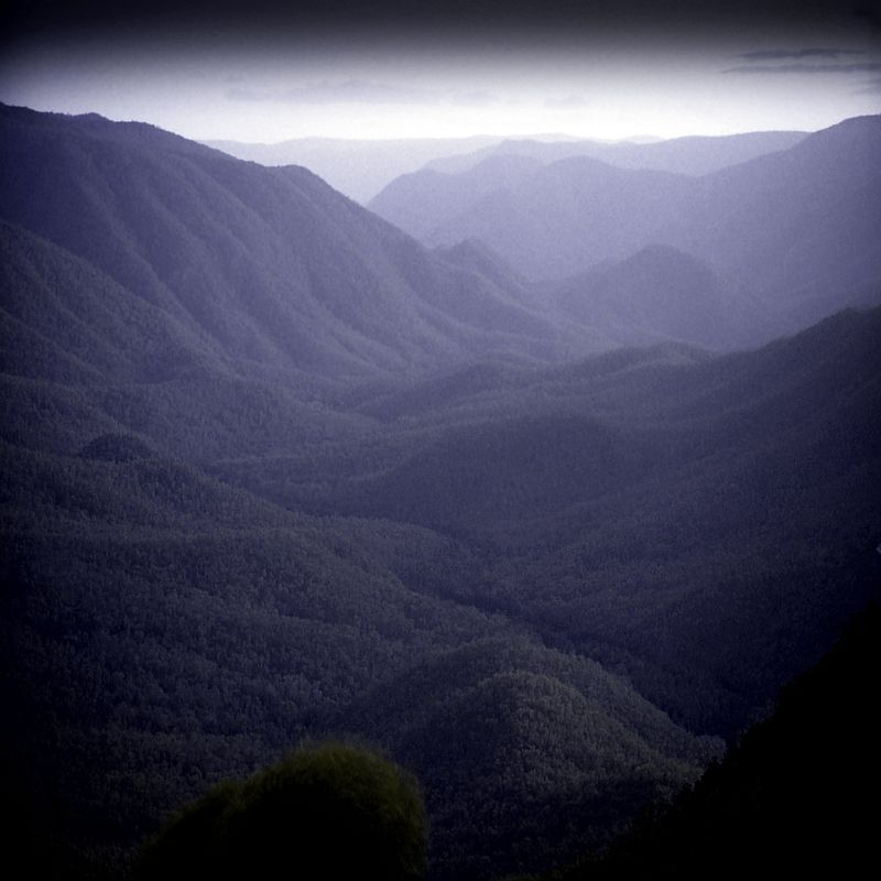
On the BNT in Victoria. Wild and very steep.
Warren.
"But on steep descending...Larson TT have bad effect on the mind of a rider" - MadRider from Suji, Korea 2001.
"Paved roads ... another fine example of wasteful government spending." - a bumper sticker.
"Paved roads ... another fine example of wasteful government spending." - a bumper sticker.
-
Meditator
- Posts: 292
- Joined: Sat Feb 11, 2012 1:57 pm
- Location: North of Cairns
Re: Bicentennial National Trail
I"ll bear this all in mind.
But as i am not heading off any time soon, there's no need to phone in the near future really, that's why i didn't do it.
About the costs that you gave, it would helpful to know all that is included and all that is excluded. eg is food included? You'd have to eat anyway. But don't worry, its not a statistic i am going to bother getting my head in a knot about.
I'll check out the link you gave. Its staggering how many tyres that guy went through. He can't have had very good ones. Or perhaps he kept them very deflated. A lot of cyclists on rough tracks do that. I always like to keep mine hard, even when going through sand. And he probably carried too much gear. I'm going to buy schwalbe mondials (not folding) and i do fully expect them to last the distance. I would not carry a spare anyway. I would buy one on route if it were necessary. There's many ways to keep a tyre going I'm told. Obviously that guy didn't know about those tricks.
-
Meditator
- Posts: 292
- Joined: Sat Feb 11, 2012 1:57 pm
- Location: North of Cairns
Re: Bicentennial National Trail
I"ve just found an online map about the alp walking trail which goes from Walhalla almost to canberra. Perhaps this would be a better tack to follow for this part of the country. I don't if one can ride a bike on it but i don't mind walking. Its only about 450km i think. Reading over big nasty trail's version, it seems a bit crazy to ride that part of the trail. But i'll keep exploring.
Someone else mentioned to me starting at walhalla which they said was a nicer place to start.
Someone else mentioned to me starting at walhalla which they said was a nicer place to start.
-
silentbutdeadly
- Posts: 2294
- Joined: Fri Apr 09, 2010 9:52 am
- Location: Somewhere flat...
Re: Bicentennial National Trail
I'd fully expect you to spend a great deal of time walking. They are great tyres but they are not steep, wet, muddy trail tyres. At least since you'll be walking so much it'll be even harder to get punctures...Meditator wrote: I'm going to buy schwalbe mondials (not folding) and i do fully expect them to last the distance. I would not carry a spare anyway.
Ours is not to reason why...merely to point and giggle
-
Meditator
- Posts: 292
- Joined: Sat Feb 11, 2012 1:57 pm
- Location: North of Cairns
Re: Bicentennial National Trail
hmm my last attempt to post didnt' go.
Anyhow silent, what tyres do you recommend for the journey? Have you ridden on Mondials? They are meant for off road as well on. On the basis of how tough i have found just the simple marathons (as well as the many recommendations), i've chosen to go with the mondials.
I mean in two outback trips (3000km around the kimberley and 2000 from cairns to darwin along the savanannah way (there are a lot of sharp rocks on that route), i've covered quite a bit of track that was really tough on tyres and they held up. I am thinking of taking them on one more trip on tar and then binning them.
Moreover, now i'm thinking of walking from melbourne to canberra via the alpine trail AAWT and continuing the rest by bike. This should cut out some of the roughest sections perhaps.
-
trailgumby
- Posts: 15469
- Joined: Sat Jan 03, 2009 5:30 pm
- Location: Northern Beaches, Sydney
- Contact:
Re: Bicentennial National Trail
I'm not understanding why, for the sake of a piffling $400-odd this guy (or girl) Meditator is not taking the awesome short cut to the required knowledge the guide books represent? You can die out there.
What dollar value does he place on his time? NOt much it seems. I think some perspective is severely lacking.
What dollar value does he place on his time? NOt much it seems. I think some perspective is severely lacking.
-
Meditator
- Posts: 292
- Joined: Sat Feb 11, 2012 1:57 pm
- Location: North of Cairns
Re: Bicentennial National Trail
I want more bang for my buck. If i find them essential, i will consider buying them.
$400 may be piddling to you, so send me some and the rest for all the postage required.
I've chatted to other people about the guides. Its seems there are errors for so much money they should be accurate shouldn't they but why do they cost so much? Why can't you put it in one book? And why not an abbreviated version for cyclists, ie without all the horsey stuff which i believe there is a lot of.
Someone told me about how the track was supposed to go through a forest of snowgums but in fact they weren't snow gums so the rider was living in a state of uncertainty for quite some time. That was one of the errors he mentioned. Maybe they've been fixed by now.
Who is online
Users browsing this forum: No registered users