
It has come to my attention that the most recent edition of the guide does not include the East Coast Explorer route. Anyone who needs this information can pm me an email address and I'll sent them a scan.RonK wrote:If you haven't already seen it, a good book to kick off your research is the Lonely Planet Cycling Australia guide. The coastal route from Melbourne to the Gold Coast starts on page 380.
Hi friends! Australia 2012 is coming;)
-
RonK

- Posts: 11508
- Joined: Mon Aug 24, 2009 2:08 pm
- Location: If you need to know, ask me
- Contact:
Re: Hi friends! Australia 2012 is coming;)
Cycle touring blog and tour journals: whispering wheels...
-
Montgomery Brogan

- Posts: 51
- Joined: Tue Oct 04, 2011 7:07 am
- Location: Firenze, Italy
Re: Hi friends! Australia 2012 is coming;)
Ronk, your help is really precious! 
I'm preparing the ride from Orbost to Cann River. Somebody knows this route I traced?
http://www.gmap-pedometer.com/?r=5222685
After Cape Conran, instead to go towards north and A1 Princes HWY I would take this country road to arrive in Cann River. In particular I would like to have informations about the first piece from Cape Conran to Bemm River. Do you know if the route is easy? Private property (shouldn't be as National Park)? Warnings? I will not use GPS and I would take this route only if easy to follow. From the satellite view don't seem difficult..
Thanxs!
-
WarrenH

- Posts: 664
- Joined: Fri May 28, 2010 3:58 am
Re: Hi friends! Australia 2012 is coming;)
Monty G'day. An assessment of your route from Orbost to Cann River.
Between Orbost and Cape Conran, excellent terrain, with a terrific aspect to the mouth of the Snowy River and to Cape Conran ... all good, apart from the freezing winds off the Bass Straits. This is wild country at times, and non wilder than in winter when the wind can freeze your bones.
From Cape Conran to Bemm River you have chosen the Pearl Point Track. This is a walking track only in Cape Conran National Park, cycling is not allowed here.
Could I suggest that you download this map. ... http://www.dse.vic.gov.au/recreation-an ... road-tours This map has the back roads showing the navigable routes for East Gippsland and Far East Gippsland. If you choose a road not on this map, don't unless you have you got a good machete?
You wont see anyone during winter, because the navigable remoter roads in East Gippsland, are closed to vehicles during winter.
Some shots from Cape Conran ... in early Autumn.
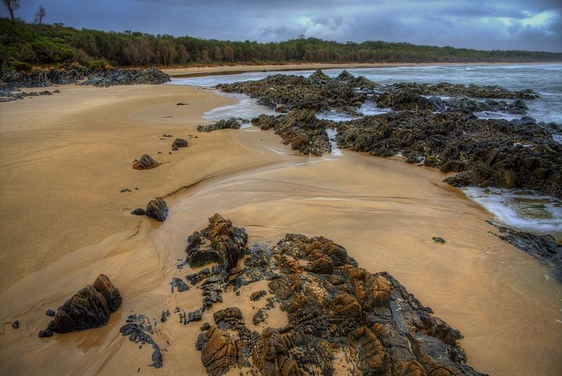
Warren.
Between Orbost and Cape Conran, excellent terrain, with a terrific aspect to the mouth of the Snowy River and to Cape Conran ... all good, apart from the freezing winds off the Bass Straits. This is wild country at times, and non wilder than in winter when the wind can freeze your bones.
From Cape Conran to Bemm River you have chosen the Pearl Point Track. This is a walking track only in Cape Conran National Park, cycling is not allowed here.
Could I suggest that you download this map. ... http://www.dse.vic.gov.au/recreation-an ... road-tours This map has the back roads showing the navigable routes for East Gippsland and Far East Gippsland. If you choose a road not on this map, don't unless you have you got a good machete?
You wont see anyone during winter, because the navigable remoter roads in East Gippsland, are closed to vehicles during winter.
Some shots from Cape Conran ... in early Autumn.
Warren.
"But on steep descending...Larson TT have bad effect on the mind of a rider" - MadRider from Suji, Korea 2001.
"Paved roads ... another fine example of wasteful government spending." - a bumper sticker.
"Paved roads ... another fine example of wasteful government spending." - a bumper sticker.
-
WarrenH
- Posts: 664
- Joined: Fri May 28, 2010 3:58 am
Re: Hi friends! Australia 2012 is coming;)
Spirito, thank you Mate for your nice comments. I'm pleased that you like the shots.
Spirito, Monty, pbike2012, you guys might like my latest tour journal, riding onto the Yass Plains and SW Slopes of NSW, which I did over a couple of rides during October and November.
I still have to add text and captions to several of the roads and photos, about Shaun the Sheep ... http://www.crazyguyonabike.com/doc/?o=1 ... =9650&v=Ol
"But on steep descending...Larson TT have bad effect on the mind of a rider" - MadRider from Suji, Korea 2001.
"Paved roads ... another fine example of wasteful government spending." - a bumper sticker.
"Paved roads ... another fine example of wasteful government spending." - a bumper sticker.
-
Montgomery Brogan
- Posts: 51
- Joined: Tue Oct 04, 2011 7:07 am
- Location: Firenze, Italy
Re: Hi friends! Australia 2012 is coming;)
Buongiorno Warren.
 Even if usually I'll use sealed roads..I need some wild road
Some shots from Cape Conran ... in early Autumn.
your photos are always a great show More real than real life.
Andrea
Your informations about the weather will remember me to not forget a good wind shield and good equipment.WarrenH wrote:This is wild country at times, and non wilder than in winter when the wind can freeze your bones.
It's a pity..but I'll check your map for back roadsWarrenH wrote:From Cape Conran to Bemm River you have chosen the Pearl Point Track. This is a walking track only in Cape Conran National Park, cycling is not allowed here.
I have used machete during my travel in Amazzonia..many times for many days, some years ago. I'll choose a road in the mapWarrenH wrote:If you choose a road not on this map, don't unless you have you got a good machete?
I didn't know. Useful information.WarrenH wrote:You wont see anyone during winter, because the navigable remoter roads in East Gippsland, are closed to vehicles during winter.
Some shots from Cape Conran ... in early Autumn.
your photos are always a great show
Andrea
-
rifraf

- Posts: 3851
- Joined: Fri Apr 15, 2011 5:55 pm
- Location: Two Rocks, WA
Re: Hi friends! Australia 2012 is coming;)
Warren I love that top pic.
It looks to me, like I could step into it and be there.
Tis a warm day here today in Mudgee but your photo
almost has me reaching for my fleece jacket.
Cheers
Aidan
It looks to me, like I could step into it and be there.
Tis a warm day here today in Mudgee but your photo
almost has me reaching for my fleece jacket.
Cheers
Aidan
Surly Ogre, Extrawheel trailer.
-
WarrenH
- Posts: 664
- Joined: Fri May 28, 2010 3:58 am
Re: Hi friends! Australia 2012 is coming;)
Rif, Cheers Mate. Yesterday was shocking and affecting ... and it only got to 35°C. I cant wait till it goes to 40°+ in a few days time.
Monty, "I need some wild road" Then may I suggest? ... when touring south to north in New South Wales, during winter there will not be much traffic at all. Most Bogans and Hoons stay at home and watch foolball during winter.
Two pleasantly wildish type rides; Starting in the historic town of Central Tilba; Take the Punkalla-Tilba Road to Wagonga Scenic Drive, continue north along WSD, then right into Box Cutting Road then take Kianga Road to the Pacific Highway. This ride will finish one kilometre north of Narooma.
Or,again from Central Tilba; Take Corkhill Drive to the Pacific Highway (after 1.4 km) turn right into the Sunnyside Road, left into Mystery Bay Road, left onto the Princes Highway (only 500m to) Watertank Road, then north on the Old Pacific Highway, then right onto Wagonga Scenic Drive back to the Pacific Highway ... finishing one kilometre South of Narooma.
Getting a bit wilder: North of Goulburn is Taralga. Taralga to Mittagong on the Wombeyan Caves Road ... aka on the Wollondilly River Road. World class caves with world class views and camp on the beautiful Wollondilly River.
A good wildish ride; From the historic gold mining towns of Sofala (most quirky) to Hillend out on the Central Western Slopes. Starting from High Street in Hill End take the Bridal Track down-hill to Bathurst. This is a North to South down-hill route along the Turon River to the Macquarie River then to Bathurst. A recommended by me, classic wild ride in the stunning light that's illuminates the Central Western Slopes.
If you really want wild solitude with absolutely stunning scenery, creek crossings, steep and difficult descents at times, take on the Bicentennial National Trail from Lydsdale to Aberdeen over Baal Bone Gap ... but you must go over Bells Gap too and not skirt around it. Baal Bone Gap will prepare you for Bells Gap. The Widden Valley is a stunning place. There is an old hand made coach road behind Phipps Cutting that cuts off the corner. It starts at the picnic tables at the cutting and terminates at Phipps Cutting Travelling Stock Reserve. You will need the BNT Guide Book #9 'Aberdeen to Jenolan Caves' to do this trip. I'm a Section Coordinator of the BNT, and when I get feedback from riders who do the BNT the first thing they mention is ... the Widden section, mentioned without fail. The second thing that they mention, without fail, is getting lost in the Croombits (that's in Qld). Avoid the Croombits.
All of the dirt roads through the World Heritage Rain Forest Parks like New England, Mount Chalundi, Mount Hyland and Mount Seaview are wet and wild. Just the fire trails alone in these regions are worth a world heritage listing.
The Old Grafton Road. No more needs to be said ... apart from just do it. You will thank me in the morning, .. .
.
If you go to the Bicentennial National Trail site ... have a look at the alternate cycle routes for both New South Wales and Queensland. Every one of the suggested alternate cycle routes is well worth the trouble, excluding the Australian Alps in winter, of course. Don't forget that crocodiles in Qld, are found north of the Mulgrave River, including found at some inland river crossings.
I hope this helps. I can post shots, but I'd tend to overdose with this number of tracks ... so I wont post shots unless you want to see them.
Warren.
PS, then there are the tracks to Pigeon House Mountain, inland from Ulladulla, ... and Long Gully Road at the base of the Castle and Byangee Walls. At Belltrees, go up Belltrees Mountain and view the Barrington Tops and from historic Stroud and Glouster there is the terribly, terribly scenic, Giro Road ... etc, etc, etc.
Monty, "I need some wild road" Then may I suggest? ... when touring south to north in New South Wales, during winter there will not be much traffic at all. Most Bogans and Hoons stay at home and watch foolball during winter.
Two pleasantly wildish type rides; Starting in the historic town of Central Tilba; Take the Punkalla-Tilba Road to Wagonga Scenic Drive, continue north along WSD, then right into Box Cutting Road then take Kianga Road to the Pacific Highway. This ride will finish one kilometre north of Narooma.
Or,again from Central Tilba; Take Corkhill Drive to the Pacific Highway (after 1.4 km) turn right into the Sunnyside Road, left into Mystery Bay Road, left onto the Princes Highway (only 500m to) Watertank Road, then north on the Old Pacific Highway, then right onto Wagonga Scenic Drive back to the Pacific Highway ... finishing one kilometre South of Narooma.
Getting a bit wilder: North of Goulburn is Taralga. Taralga to Mittagong on the Wombeyan Caves Road ... aka on the Wollondilly River Road. World class caves with world class views and camp on the beautiful Wollondilly River.
A good wildish ride; From the historic gold mining towns of Sofala (most quirky) to Hillend out on the Central Western Slopes. Starting from High Street in Hill End take the Bridal Track down-hill to Bathurst. This is a North to South down-hill route along the Turon River to the Macquarie River then to Bathurst. A recommended by me, classic wild ride in the stunning light that's illuminates the Central Western Slopes.
If you really want wild solitude with absolutely stunning scenery, creek crossings, steep and difficult descents at times, take on the Bicentennial National Trail from Lydsdale to Aberdeen over Baal Bone Gap ... but you must go over Bells Gap too and not skirt around it. Baal Bone Gap will prepare you for Bells Gap. The Widden Valley is a stunning place. There is an old hand made coach road behind Phipps Cutting that cuts off the corner. It starts at the picnic tables at the cutting and terminates at Phipps Cutting Travelling Stock Reserve. You will need the BNT Guide Book #9 'Aberdeen to Jenolan Caves' to do this trip. I'm a Section Coordinator of the BNT, and when I get feedback from riders who do the BNT the first thing they mention is ... the Widden section, mentioned without fail. The second thing that they mention, without fail, is getting lost in the Croombits (that's in Qld). Avoid the Croombits.
All of the dirt roads through the World Heritage Rain Forest Parks like New England, Mount Chalundi, Mount Hyland and Mount Seaview are wet and wild. Just the fire trails alone in these regions are worth a world heritage listing.
The Old Grafton Road. No more needs to be said ... apart from just do it. You will thank me in the morning, ..
If you go to the Bicentennial National Trail site ... have a look at the alternate cycle routes for both New South Wales and Queensland. Every one of the suggested alternate cycle routes is well worth the trouble, excluding the Australian Alps in winter, of course. Don't forget that crocodiles in Qld, are found north of the Mulgrave River, including found at some inland river crossings.
I hope this helps. I can post shots, but I'd tend to overdose with this number of tracks ... so I wont post shots unless you want to see them.
Warren.
PS, then there are the tracks to Pigeon House Mountain, inland from Ulladulla, ... and Long Gully Road at the base of the Castle and Byangee Walls. At Belltrees, go up Belltrees Mountain and view the Barrington Tops and from historic Stroud and Glouster there is the terribly, terribly scenic, Giro Road ... etc, etc, etc.
"But on steep descending...Larson TT have bad effect on the mind of a rider" - MadRider from Suji, Korea 2001.
"Paved roads ... another fine example of wasteful government spending." - a bumper sticker.
"Paved roads ... another fine example of wasteful government spending." - a bumper sticker.
-
KenGS

- Posts: 1474
- Joined: Thu Sep 10, 2009 10:31 pm
- Location: Rosanna, Victoria
Re: Hi friends! Australia 2012 is coming;)
Last March I rode the other direction from Bemm River to Cape Conran along the Old Coast Road which is not on the coast but several km inland. Generally ok with a few sandy spots. It is not marked on Google maps but I plotted the road onto openstreetmap. It is quite easy to follow especially in the direction you are going.Montgomery Brogan wrote:Ronk, your help is really precious!
I'm preparing the ride from Orbost to Cann River. Somebody knows this route I traced?
http://www.gmap-pedometer.com/?r=5222685
After Cape Conran, instead to go towards north and A1 Princes HWY I would take this country road to arrive in Cann River. In particular I would like to have informations about the first piece from Cape Conran to Bemm River. Do you know if the route is easy? Private property (shouldn't be as National Park)? Warnings? I will not use GPS and I would take this route only if easy to follow. From the satellite view don't seem difficult..
Thanxs!
My write up on CGOAB http://www.crazyguyonabike.com/doc/page ... 83573&v=1t
Watch out for the kookaburra at Cape Conran picnic ground !
--Ken
Helmets! Bells! Rego!
Helmets! Bells! Rego!
-
Montgomery Brogan
- Posts: 51
- Joined: Tue Oct 04, 2011 7:07 am
- Location: Firenze, Italy
Re: Hi friends! Australia 2012 is coming;)
I'm going to study the roads you told me guys;)
-
Montgomery Brogan
- Posts: 51
- Joined: Tue Oct 04, 2011 7:07 am
- Location: Firenze, Italy
Re: Hi friends! Australia 2012 is coming;)
Ciao!
I have just finished to prepare the first part of my journey from Melbourne to Sydney (Opera House )
For now are 1759 km in 20 days. Plus 10/12 of rest and visit.
I have another month to discover the beauties of NSW and Queensland.
These are the rides MEL-SYD, without consider days for rest and visit
VICTORIA
D1) Train from Melbourne to Warrnambool
Victoria - Great Ocean Road - Da Warrnambool a Port Campbell - km 68
http://www.gmap-pedometer.com/?r=5199463
D2) Victoria - Great Ocean Road - Da Port Campbell a Cape Otway- km 87
http://www.gmap-pedometer.com/?r=5199467
D3) Victoria - Great Ocean Road - Da Cape Otway a Lorne - km 76
http://www.gmap-pedometer.com/?r=5199470
D4) Victoria - Great Ocean Road - Da Lorne a Queenscliff - km 87
Pernottamento e traghetto per Sorrento il giorno dopo dall’altra parte della baia.
http://www.gmap-pedometer.com/?r=5199472
D5) Victoria - Mornington Peninsula - Da Sorrento a Crib Point - km 79
http://www.gmap-pedometer.com/?r=5199473
D6) Victoria - Da Cowes a Venus Bay
con Railtrail, vecchia ferrovia in disuso, da Anderson a Wonthaggi di 16 km - km 87
http://www.gmap-pedometer.com/?r=5199475
D7) Victoria - Da Venus Bay a Tidal River ("The Prom") - km 110
http://www.gmap-pedometer.com/?r=5199477
D8) Victoria - Da Tidal River a Port Albert - km 116
http://www.gmap-pedometer.com/?r=5199479
D9) Victoria - Da Port Albert a Sale- km 90
http://www.gmap-pedometer.com/?r=5199480
D10) Victoria - Lake District - Da Sale a Metung- km 104
http://www.gmap-pedometer.com/?r=5199482
D11) Victoria - Lake District - Metung a Lakes Entrance - km 20
http://www.gmap-pedometer.com/?r=5222652
D12) Victoria - Lakes Entrance a Orbost
Tappa con 2 Rail Trail / Gippsland Lakes Discovery trail + East Gippsland Rail Trail - km 75
http://www.gmap-pedometer.com/?r=5222650
D13) Victoria - Orbost a Cann River - km 91
http://www.gmap-pedometer.com/?r=5222686
D14) Victoria - Cann River a Mallacoota - km 70
http://www.gmap-pedometer.com/?r=5222864
NEW SOUTH WALLES
D15) New South Walles - Mallacoota a Merimbula - km 109
http://www.gmap-pedometer.com/?r=5222874
D16) New South Walles - Merimbula a Central Tilba - km 87
http://www.gmap-pedometer.com/?r=5242378
D17) New South Walles - Central Tilba a Batemans Bay - km 104
http://www.gmap-pedometer.com/?r=5242380
D18) New South Walles - Batemans Bay a Huskisson - km 106
http://www.gmap-pedometer.com/?r=5242382
D19) New South Walles - Huskisson a Woolongong - km 100
http://www.gmap-pedometer.com/?r=5242390
D20) New South Walles - Woolongong a Sydney Opera House - km 93
http://www.gmap-pedometer.com/?r=5242946
Andrea
I have just finished to prepare the first part of my journey from Melbourne to Sydney (Opera House
For now are 1759 km in 20 days. Plus 10/12 of rest and visit.
I have another month to discover the beauties of NSW and Queensland.
These are the rides MEL-SYD, without consider days for rest and visit
VICTORIA
D1) Train from Melbourne to Warrnambool
Victoria - Great Ocean Road - Da Warrnambool a Port Campbell - km 68
http://www.gmap-pedometer.com/?r=5199463
D2) Victoria - Great Ocean Road - Da Port Campbell a Cape Otway- km 87
http://www.gmap-pedometer.com/?r=5199467
D3) Victoria - Great Ocean Road - Da Cape Otway a Lorne - km 76
http://www.gmap-pedometer.com/?r=5199470
D4) Victoria - Great Ocean Road - Da Lorne a Queenscliff - km 87
Pernottamento e traghetto per Sorrento il giorno dopo dall’altra parte della baia.
http://www.gmap-pedometer.com/?r=5199472
D5) Victoria - Mornington Peninsula - Da Sorrento a Crib Point - km 79
http://www.gmap-pedometer.com/?r=5199473
D6) Victoria - Da Cowes a Venus Bay
con Railtrail, vecchia ferrovia in disuso, da Anderson a Wonthaggi di 16 km - km 87
http://www.gmap-pedometer.com/?r=5199475
D7) Victoria - Da Venus Bay a Tidal River ("The Prom") - km 110
http://www.gmap-pedometer.com/?r=5199477
D8) Victoria - Da Tidal River a Port Albert - km 116
http://www.gmap-pedometer.com/?r=5199479
D9) Victoria - Da Port Albert a Sale- km 90
http://www.gmap-pedometer.com/?r=5199480
D10) Victoria - Lake District - Da Sale a Metung- km 104
http://www.gmap-pedometer.com/?r=5199482
D11) Victoria - Lake District - Metung a Lakes Entrance - km 20
http://www.gmap-pedometer.com/?r=5222652
D12) Victoria - Lakes Entrance a Orbost
Tappa con 2 Rail Trail / Gippsland Lakes Discovery trail + East Gippsland Rail Trail - km 75
http://www.gmap-pedometer.com/?r=5222650
D13) Victoria - Orbost a Cann River - km 91
http://www.gmap-pedometer.com/?r=5222686
D14) Victoria - Cann River a Mallacoota - km 70
http://www.gmap-pedometer.com/?r=5222864
NEW SOUTH WALLES
D15) New South Walles - Mallacoota a Merimbula - km 109
http://www.gmap-pedometer.com/?r=5222874
D16) New South Walles - Merimbula a Central Tilba - km 87
http://www.gmap-pedometer.com/?r=5242378
D17) New South Walles - Central Tilba a Batemans Bay - km 104
http://www.gmap-pedometer.com/?r=5242380
D18) New South Walles - Batemans Bay a Huskisson - km 106
http://www.gmap-pedometer.com/?r=5242382
D19) New South Walles - Huskisson a Woolongong - km 100
http://www.gmap-pedometer.com/?r=5242390
D20) New South Walles - Woolongong a Sydney Opera House - km 93
http://www.gmap-pedometer.com/?r=5242946
Andrea
-
WarrenH
- Posts: 664
- Joined: Fri May 28, 2010 3:58 am
Re: Hi friends! Australia 2012 is coming;)
Monty, G'day.
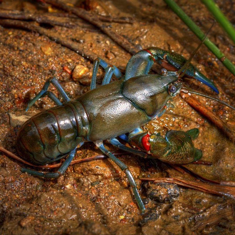
Yabbies, are fresh water crayfish. Yabbies are an Australian delicacy. Yabbies have more meat on them, relative to their size, than any other crayfish. Heading up the coast you'll pass a few Yabbie farms. The guys there will tell you how best to cook them. Normally they are just boiled in salt water for 5-6 minutes. A bit longer about 7-8 minutes, for the really big ones. They can grow to 20 cm in length. If you like crayfish ... they are a must try.
A Murrumbidgee Blue Claw Yabbie. Normally Yabbies like muddy water, but in the Murrumbidgee River, you can catch Yabbies, Murray River Crays and Spiny Freshwater Crayfish.
In December, one of my friends, Andy Friend rode through Widden, travelling North to South. Andy has a blog about his ride and the section through Widden is on Days 76-83, during this time Andy had a few rest days ... http://www.andyfriend.com.au/blog
Warren.
Yabbies, are fresh water crayfish. Yabbies are an Australian delicacy. Yabbies have more meat on them, relative to their size, than any other crayfish. Heading up the coast you'll pass a few Yabbie farms. The guys there will tell you how best to cook them. Normally they are just boiled in salt water for 5-6 minutes. A bit longer about 7-8 minutes, for the really big ones. They can grow to 20 cm in length. If you like crayfish ... they are a must try.
A Murrumbidgee Blue Claw Yabbie. Normally Yabbies like muddy water, but in the Murrumbidgee River, you can catch Yabbies, Murray River Crays and Spiny Freshwater Crayfish.
If you go to Aberdeen via Widden on the Bicentennial National Trail you will enter the Widden Valley along Myrte Creek, these links by Dave Noble might help with your study ... http://www.david-noble.net/BlueMts/Widden/Widden1.html ... http://www.david-noble.net/BlueMts/Widd ... Range.html ... http://www.david-noble.net/BlueMts/Widden/Widden2.htmlMontgomery Brogan wrote:I'm going to study the roads you told me guys;)
In December, one of my friends, Andy Friend rode through Widden, travelling North to South. Andy has a blog about his ride and the section through Widden is on Days 76-83, during this time Andy had a few rest days ... http://www.andyfriend.com.au/blog
Warren.
"But on steep descending...Larson TT have bad effect on the mind of a rider" - MadRider from Suji, Korea 2001.
"Paved roads ... another fine example of wasteful government spending." - a bumper sticker.
"Paved roads ... another fine example of wasteful government spending." - a bumper sticker.
-
Montgomery Brogan
- Posts: 51
- Joined: Tue Oct 04, 2011 7:07 am
- Location: Firenze, Italy
Re: Hi friends! Australia 2012 is coming;)
Hi guys!
...after almost two months of pause..the second part of preparation of my solo journey in Australia ..has begun! In about 100 days I'll be there, can't wait! Now "I'm" at Coffs Harbour...trying to find the best route to north towards Byron Bay...I wouldn't like to do the Pacific HWY. Suggestions?
Ciao! Monty
p.s. Is there someone that will partecipate at "Strade Bianche Eroica race 2012" in Tuscany? I know there are many australians.
...after almost two months of pause..the second part of preparation of my solo journey in Australia ..has begun!
Ciao! Monty
p.s. Is there someone that will partecipate at "Strade Bianche Eroica race 2012" in Tuscany?
-
il padrone

- Posts: 22931
- Joined: Mon Apr 07, 2008 11:57 pm
- Location: Heading for home.
Re: Hi friends! Australia 2012 is coming;)
HI
One comment about your travels through Victoria. It all looks to be very good, but if you are taking the trouble to go down to Wilsons Prom, it would be a waste of time to just turn around and ride out the next day. The Prom certainly justifies one, or even two rest days there, especially if you like hiking or the beach.
A bit like going to Rome and just staying overnight
Mandatory helmet law?
"An unjustified and unethical imposition on a healthy activity."
"An unjustified and unethical imposition on a healthy activity."
-
Montgomery Brogan
- Posts: 51
- Joined: Tue Oct 04, 2011 7:07 am
- Location: Firenze, Italy
Re: Hi friends! Australia 2012 is coming;)
Ciao Mate!
Right!!
Infact I'll stay at Prom for 2 days of rest (I mean trekking! ..not true rest;) ...seems to be a wonderful place for walk and nature!
M.
Right!!
Infact I'll stay at Prom for 2 days of rest (I mean trekking! ..not true rest;) ...seems to be a wonderful place for walk and nature!
M.
-
Montgomery Brogan
- Posts: 51
- Joined: Tue Oct 04, 2011 7:07 am
- Location: Firenze, Italy
Re: Hi friends! Australia 2012 is coming;)
....and these are the last rides I prepared, from Sydney towards Blue Mountains and north, Queensland.
D21) New South Wales - Sydney Central Station - Katoomba (Blue Mountains) km 65
Train transfer to katoomba with CityRail
D22) New South Wales - Katoomba (Blue Mountains) - Wisemans Ferry - km 109
http://www.gmap-pedometer.com/?r=5342773
D23) New South Wales - Wisemans Ferry - Cessnock - km 108
http://www.gmap-pedometer.com/?r=5342776
D24) New South Wales - Cessnock - Nelson Bay - km 90
http://www.gmap-pedometer.com/?r=5342781
Ferry from Nelson Bay to Tea Garden
D25) New South Wales - Tea Garden - Forster - km 107
http://www.gmap-pedometer.com/?r=5342782
D26) New South Wales - Forster - Port Macquarie - km 118
http://www.gmap-pedometer.com/?r=5342783
D27) New South Wales - Port Macquarie - South West Rocks - km 77
http://www.gmap-pedometer.com/?r=5342784
D28) New South Wales - South West Rocks - Coffs Harbour - km 109
http://www.gmap-pedometer.com/?r=5342786
D29) New South Wales - Coffs Harbour - Grafton - km 87
http://www.gmap-pedometer.com/?r=5342787
D30) New South Wales - Grafton - Casino - km 100
http://www.gmap-pedometer.com/?r=5342788
D31) New South Wales - Casino - Byron Bay - km 78
http://www.gmap-pedometer.com/?r=5342789
QUEENSLAND
D32) Queensland - Byron Bay - Surfers Paradise - km 95
http://www.gmap-pedometer.com/?r=5342790
D33) Queensland - Surfers Paradise - Nerang Station - km 10
http://www.gmap-pedometer.com/?r=5342792
Train transfer to avoid Brisbane's metropolitan area.
Queensland - Beerburrum - House Glass Mountains - km 7
http://www.gmap-pedometer.com/?r=5342793
D34) Queensland - House Glass Mountains - Noosa Heads - km 75
http://www.gmap-pedometer.com/?r=5342795
D35) Queensland - Noosa Heads - Gympie - km 75
http://www.gmap-pedometer.com/?r=5342797
D36) Queensland - Gympie - Tin Can Bay - km 51
http://www.gmap-pedometer.com/?r=5342799
D37) Queensland - Tin Can Bay - Hervey Bay (Fraser Island) - km 109
http://www.gmap-pedometer.com/?r=5342800
Always tried to avoid HWY and similar (but sometimes there are not alternative ), at this point of preparation the progressive distance is 3.159 km, from Warnambool (VIC) to Hervey Bay / Fraser (QUEE). May be I'll arrive at 3.400 / 3.500 km for the whole trip.
I would like to have the opportunity to see also the coral reef and also just a bite of outback!!! I could take a train to Cairns or another place to enjoy the reef and then, comeback to Melbourne with a national flight.
As usually, every suggestion will be super apreciated!
Monty
D21) New South Wales - Sydney Central Station - Katoomba (Blue Mountains) km 65
Train transfer to katoomba with CityRail
D22) New South Wales - Katoomba (Blue Mountains) - Wisemans Ferry - km 109
http://www.gmap-pedometer.com/?r=5342773
D23) New South Wales - Wisemans Ferry - Cessnock - km 108
http://www.gmap-pedometer.com/?r=5342776
D24) New South Wales - Cessnock - Nelson Bay - km 90
http://www.gmap-pedometer.com/?r=5342781
Ferry from Nelson Bay to Tea Garden
D25) New South Wales - Tea Garden - Forster - km 107
http://www.gmap-pedometer.com/?r=5342782
D26) New South Wales - Forster - Port Macquarie - km 118
http://www.gmap-pedometer.com/?r=5342783
D27) New South Wales - Port Macquarie - South West Rocks - km 77
http://www.gmap-pedometer.com/?r=5342784
D28) New South Wales - South West Rocks - Coffs Harbour - km 109
http://www.gmap-pedometer.com/?r=5342786
D29) New South Wales - Coffs Harbour - Grafton - km 87
http://www.gmap-pedometer.com/?r=5342787
D30) New South Wales - Grafton - Casino - km 100
http://www.gmap-pedometer.com/?r=5342788
D31) New South Wales - Casino - Byron Bay - km 78
http://www.gmap-pedometer.com/?r=5342789
QUEENSLAND
D32) Queensland - Byron Bay - Surfers Paradise - km 95
http://www.gmap-pedometer.com/?r=5342790
D33) Queensland - Surfers Paradise - Nerang Station - km 10
http://www.gmap-pedometer.com/?r=5342792
Train transfer to avoid Brisbane's metropolitan area.
Queensland - Beerburrum - House Glass Mountains - km 7
http://www.gmap-pedometer.com/?r=5342793
D34) Queensland - House Glass Mountains - Noosa Heads - km 75
http://www.gmap-pedometer.com/?r=5342795
D35) Queensland - Noosa Heads - Gympie - km 75
http://www.gmap-pedometer.com/?r=5342797
D36) Queensland - Gympie - Tin Can Bay - km 51
http://www.gmap-pedometer.com/?r=5342799
D37) Queensland - Tin Can Bay - Hervey Bay (Fraser Island) - km 109
http://www.gmap-pedometer.com/?r=5342800
Always tried to avoid HWY and similar (but sometimes there are not alternative
I would like to have the opportunity to see also the coral reef and also just a bite of outback!!! I could take a train to Cairns or another place to enjoy the reef and then, comeback to Melbourne with a national flight.
As usually, every suggestion will be super apreciated!
Monty
-
Montgomery Brogan
- Posts: 51
- Joined: Tue Oct 04, 2011 7:07 am
- Location: Firenze, Italy
Re: Hi friends! Australia 2012 is coming;)
to do this..I just booked via web on "The Sunlander" from Maryborough West to Proserpine, night trip. From Proserpine I'll do the last 5 days on bike along the coast of Queensland until Townsville. One question...I bought a ticket for me but I'm not sure to understand if I have to do another ticket for the bike??Montgomery Brogan wrote:I would like to have the opportunity to see also the coral reef....
...and in case, where? When?
I have to trace the last 260 km from Proserpine to Townsville and then, preparation of my Australia Tour 2012 will be over!
JetStar Flight from Townsville to Melbourne on 29/8. I also checked Virgin Australia for the internal flight but the baggage policy regarding bikes is not so good! Only 23 kg accepted.. ;(
-
il padrone
- Posts: 22931
- Joined: Mon Apr 07, 2008 11:57 pm
- Location: Heading for home.
Re: Hi friends! Australia 2012 is coming;)
Have a look here for baggage amounts and excess. You could fly Premium Economy for 69kg allowance. Not sure whether under the Saver fare you can buy two lots of 23kg for $12 each ?? I have been told that it is possible to buy an extra 10kg for a reasonable cost, much cheaper than paying excess at check-in.
[edit] Qantas allow the purchase of an extra two pieces of baggage (23kgs per item) for $20 per item.
[edit] Qantas allow the purchase of an extra two pieces of baggage (23kgs per item) for $20 per item.
Mandatory helmet law?
"An unjustified and unethical imposition on a healthy activity."
"An unjustified and unethical imposition on a healthy activity."
-
Aushiker

- Posts: 22396
- Joined: Tue Jun 05, 2007 1:55 pm
- Location: Walyalup land
- Contact:
Re: Hi friends! Australia 2012 is coming;)
As I understand it you can only only buy this extra baggage allowance from sevens days before the flight. I know I cannot buy mine for the Darwin flight until then.il padrone wrote:[edit] Qantas allow the purchase of an extra two pieces of baggage (23kgs per item) for $20 per item.
Andrew
Andrew
Aushiker.com
Aushiker.com
-
Montgomery Brogan
- Posts: 51
- Joined: Tue Oct 04, 2011 7:07 am
- Location: Firenze, Italy
Re: Hi friends! Australia 2012 is coming;)
mmhhh...I compared 3-4 airlines, Qantas, Virgin, JetStar and Tiger. I decided to book with Jetstar, buying a ticket with 30 kg of checked baggage (includes sport equipment & bikes) for the bike with a little surplus. Final price 215 AUD. Reasonable.
-
Montgomery Brogan
- Posts: 51
- Joined: Tue Oct 04, 2011 7:07 am
- Location: Firenze, Italy
Re: Hi friends! Australia 2012 is coming;)
Guys, I take the opportunity to invite you to partecipate with me, for 1 km or 100, to this trip. In the next days I'll publish the indicative dates where I'll be during the trip. If someone wants to join for a piece I will be more than happy to ride Australia with locals! My nightmare english could improve ....your italian too!
-
Montgomery Brogan
- Posts: 51
- Joined: Tue Oct 04, 2011 7:07 am
- Location: Firenze, Italy
Re: Hi friends! Australia 2012 is coming;)
G'day Mate!
Planning is over. In about 40 days I'll be in Melbourne to start my Australian dream.
HERE my definitive travel plan.
25 days of rest / stop
38 on bike
87 km average per day
Andrea
Planning is over. In about 40 days I'll be in Melbourne to start my Australian dream.
HERE my definitive travel plan.
25 days of rest / stop
38 on bike
87 km average per day
Andrea
-
J Quinton
- Posts: 237
- Joined: Fri Jan 06, 2012 7:52 pm
Re: Hi friends! Australia 2012 is coming;)
Sounds like a great trip.
Remember rule number 1: have fun.
Remember rule number 1: have fun.
-
RonK
- Posts: 11508
- Joined: Mon Aug 24, 2009 2:08 pm
- Location: If you need to know, ask me
- Contact:
Re: Hi friends! Australia 2012 is coming;)
Well, here's wishing you a wonderful experience in Australia. Bring warm clothes, winter has come early and it's cold...Montgomery Brogan wrote:G'day Mate!
Planning is over. In about 40 days I'll be in Melbourne to start my Australian dream.
HERE my definitive travel plan.
25 days of rest / stop
38 on bike
87 km average per day
Andrea
Cycle touring blog and tour journals: whispering wheels...
-
Montgomery Brogan
- Posts: 51
- Joined: Tue Oct 04, 2011 7:07 am
- Location: Firenze, Italy
-
Meditator
- Posts: 292
- Joined: Sat Feb 11, 2012 1:57 pm
- Location: North of Cairns
Re: Hi friends! Australia 2012 is coming;)
Its not too late to change your route. I think you should go to a warmer part of the country. Brisbane is not actually hot in winter. Its rather cold to be honest, even in the day time it can be chilly. Of course you will warm up if you are riding around. That is to say victoria is going to be very cold. YOu should fly up to alice springs, ride around there to see all the sites (there are a lot of inteeresting landscapes), then ride up to darwin visiting kakadu national park thoroughly and litchfield national park and from darwin fly back to melbourne to fly home.
If you get to melbourne and decide its cold, that's what you should do. In my opinion. Well at least its one sensible alternative. The nights in alice springs and northern territory will be cold to cool until you get up to darwin where they will be warm to hot. The days around alice springs will be mild and all the days as you travel north will get warmer. I think you will find the wind is behind you as well. So it would be a very good route.
It would also be much more interesting and give you the more exotic side of australia.
Who is online
Users browsing this forum: No registered users